
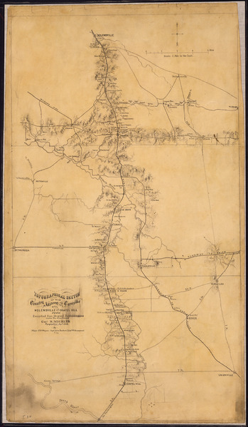
Image: Topographical Sketch of the Country Adjacent to the Turnpoke between Nolensville and Chapel Hill, Tenn. Compiled from... - NARA - 305681
Size of this JPG preview of this TIF file: 349 × 599 pixels. Other resolution: 140 × 240 pixels.
Original image (3,145 × 5,400 pixels, file size: 48.59 MB, MIME type: image/tiff)
Title: Topographical Sketch of the Country Adjacent to the Turnpoke between Nolensville and Chapel Hill, Tenn. Compiled from Original Reconnaissances under the direction of Capt. N. Michler Topographical Engr's., U.S.A., By Major J. E. Weyss, Capt. John Earhart, [and] Lieut. W. Greenwood. n.d.
Credit: U.S. National Archives and Records Administration
Author: Unknown or not provided
Usage Terms: Public domain
License: Public domain
Attribution Required?: No
Image usage
The following 2 pages link to this image:

All content from Kiddle encyclopedia articles (including the article images and facts) can be freely used under Attribution-ShareAlike license, unless stated otherwise.