
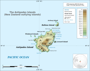
Image: Topographical map of the Antipodes Islands in English

Description: Detailed map of large dimensions. For superior viewing, click on the link of the image above. Topographic map in English of the Antipodes Islands near New Zealand. UTM projection - WGS84 datum - shaded relief (composite image of N-W, W and N lightning positions) Approximate scale of topography: 1:372,000 (precision: 93 m).
Title: Topographical map of the Antipodes Islands in English
Credit: Own work Topography and SWBD: NASA Shuttle Radar Topography Mission (SRTM3 v 2.1) edited with 3DEM from Visualization Software LLC, and GRASS GIS Other references used for additional data: NASA World Wind http://ortho.linz.govt.nz/nz_offshore_islands/antipodes_high_res.jpg http://heritage-expeditions.com/system/files/Antipodes_LRG.jpg http://www.linz.govt.nz/topography/topo-maps/nz-offshore-island/index.aspx This vector image includes elements that have been taken or adapted from this file: New Zealand (orthographic projection) 2.svg (by Avenue).
Author: Matthewedwards
Permission: I, the copyright holder of this work, hereby publish it under the following license:
Usage Terms: GNU Free Documentation License 1.2
License: GFDL 1.2
License Link: http://www.gnu.org/licenses/old-licenses/fdl-1.2.html
Attribution Required?: Yes
Image usage
The following 4 pages link to this image:
