
Image: Transoxiana 8th century

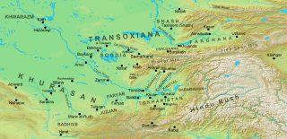
Description: Map of the region and principal localities of Transoxiana in the 8th century —. Geophysical map taken from DEMIS Mapserver, which are public domain, other wise self-made. Sources: Khalid Yahya Blankinship (1994), The end of the jihâd state: the reign of Hishām ibn ʻAbd al-Malik and the collapse of the Umayyads, State University of New York Press, ISBN 978-0-791418277, p. 243; The History of al-Tabari, Vol. XXIII: The Zenith of the Marwanid House, transl. by Martin Hinds (1990), State University of New York Press, p. xvi; Guy Le Strange (1905), The Lands of the Eastern Caliphate: Mesopotamia, Persia, and Central Asia, from the Moslem Conquest to the Time of Timur, New York: Barnes & Noble
Author: Cplakidas
Usage Terms: Creative Commons Attribution-Share Alike 3.0
License: CC-BY-SA-3.0
License Link: http://creativecommons.org/licenses/by-sa/3.0/
Attribution Required?: Yes
Image usage
The following 5 pages link to this image:
