
Image: USGS - San Jacinto Fault Zone
No higher resolution available.
USGS_-_San_Jacinto_Fault_Zone.gif (214 × 218 pixels, file size: 16 KB, MIME type: image/gif)
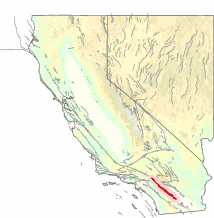
Description: Map showing the San Jacinto Fault Zone (SJFZ) outlined in red. A major strike-slip fault zone that runs through San Bernardino, Riverside, San Diego, and Imperial Counties in Southern California. The SJFZ is a component of the larger San Andreas transform system, and is considered to be the most seismically active fault zone in the area. Together they relieve the majority of the stress between the Pacific and North American tectonic plates.
Title: USGS - San Jacinto Fault Zone
Credit: [1]
Author: USGS
Usage Terms: Public domain
License: Public domain
Attribution Required?: No
Image usage
The following 3 pages link to this image:

All content from Kiddle encyclopedia articles (including the article images and facts) can be freely used under Attribution-ShareAlike license, unless stated otherwise.