San Jacinto Fault Zone facts for kids
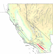
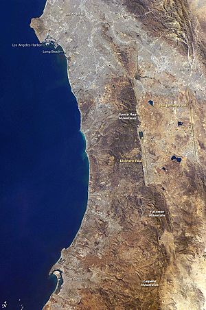
The San Jacinto Fault Zone (SJFZ) is a major fault system in Southern California. It runs through several counties, including San Bernardino, Riverside, San Diego, and Imperial. This fault zone is part of the larger San Andreas system. It helps to release most of the stress between the Pacific and North American tectonic plates.
The SJFZ is known as one of the most active fault zones in the area. It is made up of many smaller fault sections. Scientists have been studying activity along these faults since the 1890s. One part, called the Anza seismic gap, has not had a big earthquake in a long time. Experts have looked at each section to see how likely a large earthquake is to happen there.
Even though some big earthquakes on the SJFZ have not caused much damage because they happened in remote areas, the cities of Hemet and San Jacinto were badly damaged in 1899 and 1918. After 1899, strong earthquakes happened every 5 to 19 years. However, there hasn't been a strong earthquake on the SJFZ since 1987.
What Makes It Special
The San Jacinto Fault Zone and the San Andreas Fault (SAF) together handle most of the movement between the North American and Pacific plates. The SJFZ is one of California's most active fault zones. It has caused many medium and large earthquakes.
If a strong earthquake like the one in 1923 happened again today, it would cause a lot of damage and harm many people. This is because the population in the Inland Empire area has grown a lot since then.
| Segment | Length | Last rupture |
| San Bernardino | 35 km | 1890 |
| San Jacinto | 42 km | 1918 |
| Anza | 90 km | 1750 |
| Coyote Creek | 40 km | 1892 |
| Borrego Mtn | 29 km | 1968 |
| Superstition Mtn | 23 km | 1430 |
| Superstition Hills | 22 km | 1987 |
| WGCEP 1995, pp. 386, 387 | ||
Fault Sections
In 1995, a group of scientists studied the SJFZ. They found seven main sections of the fault. This group included many seismologists, who are scientists who study earthquakes. They worked to update how they predict big earthquakes along the San Andreas and San Jacinto Fault zones.
The scientists looked at how much each section moves each year. The three northern sections (San Bernardino, San Jacinto, and Anza) move about 12 millimeters (about half an inch) per year. The other four sections move about 4 millimeters (about a sixth of an inch) per year.
They also estimated the chance of a big earthquake happening on each section over 30 years. The San Bernardino (37%) and San Jacinto (43%) sections had a higher chance than thought before. The Anza section (17%) had a lower chance. Other sections like Coyote Creek (18%), Superstition Mountain (9%), and Superstition Hills (2%) also got their first estimates.
San Bernardino Valley Section
This is the northernmost part of the SJFZ. It is about 75 kilometers (47 miles) long. It runs from Cajon Pass to the San Jacinto Valley. This section is close to or crosses other faults like the San Andreas Fault.
Some medium earthquakes happened here in the 1890s. This part of the fault has not had a major earthquake in modern times. However, studies of the ground show that its last big earthquake was in the early 1800s. Similar earthquakes happen here about every 160 to 220 years.
San Jacinto Valley Section
The San Jacinto Valley is a long, narrow valley. It was formed by the movement of two main parts of the SJFZ. The valley was badly damaged by earthquakes in 1899 and 1918. The 1899 earthquake likely happened within the valley. The 1918 earthquake happened near Hemet and Anza.
Anza Seismic Gap
The Anza section is about 90 kilometers (56 miles) long. Scientists have found that three major earthquakes happened here around 1210, 1530, and 1750. This means a big earthquake (magnitude 7.0–7.5) happens here about every 250 years.
The San Jacinto Fault Zone is very active, but some parts are quieter. One quiet stretch, about 20 kilometers (12 miles) long, is near the town of Anza. Scientists call this the "Anza seismic gap." They have studied smaller earthquakes here and found that this part of the fault is stuck. If this entire section were to break, it could cause an earthquake around magnitude 6.5. If the break extended further, it could be up to a magnitude 7.0 earthquake.
Connection to the San Andreas Fault
Scientists have noticed that at least six large earthquakes on the San Jacinto Fault Zone happened after the big 1857 Fort Tejon earthquake on the San Andreas Fault. The 1857 earthquake was very long, about 360 kilometers (224 miles). It ended near where the San Jacinto Fault Zone branches off from the San Andreas Fault at the Cajon Pass.
One scientist, Christopher Sanders, found a pattern. He suggested that the 1857 earthquake sent a "strain pulse" (like a wave of stress) moving southeast. This pulse might have triggered big earthquakes as it traveled along the San Jacinto Fault Zone at a speed of about 1.7 kilometers (1 mile) per year.
Past Earthquakes
1812 San Juan Capistrano Earthquake
The details of this earthquake are not fully known. However, recent studies suggest that both the San Andreas Fault and the San Jacinto Fault Zone might have ruptured together. This would explain the damage seen from this event.
1899 San Jacinto Earthquake
On December 25, 1899, a magnitude 6.6 earthquake struck. It completely destroyed San Jacinto and Hemet. Six people died when adobe walls collapsed. A large crack, possibly a surface break of the San Jacinto Fault, appeared under a badly damaged house near Hemet. The shaking lasted for about thirty seconds. Many brick buildings in San Jacinto were heavily damaged.
1968 Borrego Mountain Earthquake
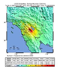
On April 9, 1968, a magnitude 6.4 earthquake hit eastern San Diego County. It caused a 31-kilometer (19-mile) crack on the surface along the Coyote Creek Fault. Roads were damaged, and large rocks fell onto highways. One house in Ocotillo Wells was split apart. The main earthquake was felt in Arizona and Nevada. The largest aftershock damaged a theater in Calexico.
This was the strongest earthquake in southern California in 15 years. Tall buildings swayed in Los Angeles and San Diego. Power went out in many areas, especially in the Imperial Valley. Telephone service was also disrupted. A brick wall fell at a laundromat, but no one was hurt. Hundreds of windows broke in San Diego. Charles Richter, a famous seismologist, said the earthquake was centered near Ocotillo Wells.
1987 Superstition Hills Earthquakes
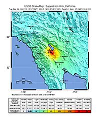
In late November 1987, two earthquakes caused about three million dollars in damage in Imperial County. The two earthquakes happened about eleven hours apart. They were located on the Superstition Hills Fault and another fault that was not known before.
Damage included fallen chimneys, broken windows, and damaged highways. A bridge failed because the ground turned to liquid (called liquefaction). Water tanks fell over at a control center. The local irrigation district estimated damage to their canals to be over $600,000.
Several smaller earthquakes, called foreshocks, happened before the main ones. Many aftershocks followed, including two that were magnitude five. In Mexico, 50 people were injured, and two died. In California, 44 people were treated for injuries. A car accident in Mexico that killed a mother and her son was blamed on the earthquake. A scientist noted that faults in this area are hard to find because of all the sediment in the valley.
The Superstition Hills fault is located between other faults that ruptured in 1968 and 1979. The first earthquake in 1987 measured 6.2 magnitude. The second, stronger earthquake, 11.4 hours later, measured 6.6 magnitude.
See also
 In Spanish: Zona de la Falla de San Jacinto para niños
- List of earthquakes in California
 | Selma Burke |
 | Pauline Powell Burns |
 | Frederick J. Brown |
 | Robert Blackburn |


