
Inland Empire facts for kids
Quick facts for kids
Inland Empire
|
|
|---|---|
.svg) |
|
 |
|
| Country | United States |
| State | California
|
| Counties |
|
| Ten largest cities by population (2010 U.S. Census) |
|
| Area | |
| • Metro | 27,298 sq mi (70,669 km2) |
| Elevation | −220 – 11,499 ft (−67.1 – 3,507 m) |
| Population
(2020)
|
|
| • Density | 147.5/sq mi (56.9/km2) |
| • Urban | 1,932,666 (22nd) |
| • Urban density | 3,434.1/sq mi (1,325.9/km2) |
| • Metro | 4,599,839 (12th) |
| • Combined Statistical Area (CSA) | 18,710,563 (2nd) |
| GDP | |
| • MSA | $237.9 billion (2022) |
| Time zone | UTC−08:00 (PST) |
| • Summer (DST) | UTC−07:00 (PDT) |
.jpg)
.jpg)


.JPG)


The Inland Empire (often called the IE) is a large area in Southern California. It's located inland, away from the coast, and is next to Los Angeles County and San Diego County. The main cities in the IE are San Bernardino and Riverside. Most people live in the western parts of Riverside County and southwestern San Bernardino County.
Sometimes, the desert areas like the Coachella and Victor Valley are also considered part of the Inland Empire. A wider definition includes all of Riverside and San Bernardino counties. These two counties together are bigger than ten U.S. states!
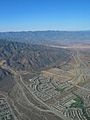
In 2020, about 4.6 million people lived in the Riverside–San Bernardino–Ontario metropolitan area. This area covers more than 27,000 square miles (70,000 square kilometers). A long time ago, in the late 1800s, the Inland Empire was famous for farming. They grew lots of citrus fruits, raised dairy cows, and made wine. Over time, farming became less common. Since the 1970s, many families moved here looking for homes they could afford. This led to a lot of new houses, factories, and shops being built.
Contents
- What Does "Inland Empire" Mean?
- A Look Back: History of the Inland Empire
- Geography and Natural Features
- Economy and Jobs in the Inland Empire
- =Shopping and Retail
- Environmental Quality
- Getting Around: Transportation
- People and Culture of the Inland Empire
- Culture and Entertainment
- Images for kids
- See also
What Does "Inland Empire" Mean?
The name Inland Empire was first used by a newspaper called the Riverside Enterprise in 1914. People who were building and developing the area probably used this name to make the region sound special. The "Inland" part means it's located away from the coast. It's about 60 miles (97 km) inland from Los Angeles and the Pacific Ocean.
This area was once called the Orange Empire. That's because there were huge orange groves from Pasadena to Redlands in the early 1900s. The exact borders of the Inland Empire can be a bit unclear. But it generally includes the cities in western Riverside County and southwestern San Bernardino County. These areas are right next to the Los Angeles metropolitan area. Some people also include Palm Springs and the nearby desert communities. A very broad definition includes all of San Bernardino and Riverside counties.
A Look Back: History of the Inland Empire

For thousands of years, Native American groups like the Tongva, Taaqtam, Ivilyuqaletem, and Payómkawichum lived in the area now known as the Inland Empire. The first American settlers arrived in 1851. They were a group of Mormon pioneers who came over the Cajon Pass. Even though the Mormons left a few years later, other settlers soon followed.
The land in Southern California was divided up using the San Bernardino Meridian starting in 1852. A main road today, Base Line Road, follows these original survey lines. San Bernardino County was created in 1853 from parts of Los Angeles County. Later, in 1893, Riverside County was formed from land that was once part of San Bernardino and San Diego counties. This happened because different cities like Colton, Redlands, Riverside, and San Bernardino had friendly rivalries. They all wanted to be the main city.
Growth and Changes Over Time
When railroads arrived and orange trees were brought in during the 1870s, the area grew very quickly. It became a major center for growing citrus fruits. This farming boom continued as water from the Colorado River became available. Dairy farming also became important. In 1926, Route 66 came through the northern parts of the area. This brought many tourists and new residents.
The region remained a key part of Southern California's "citrus belt" until after World War II. Then, new builders started clearing farmland to build suburbs. New freeways, like the Ramona Expressway (built in 1944), made it easier for people to move and for suburbs to spread across the Inland Empire.
The area saw a lot of economic and population growth in the second half of the 1900s. In the early 1990s, some military bases closed, and defense jobs decreased. This caused a local economic slowdown. However, the region started to recover by the early 2000s. It became a big center for warehousing, shipping, and retail businesses, especially around Ontario. During a big economic downturn in 2008–2009, many industries struggled. But the area began to recover by 2010.
Geography and Natural Features
Physical Landscape of the IE

The Inland Empire is separated from Los Angeles by hills like the San Jose Hills. The Santa Ana Mountains divide Orange County from Riverside County. The Santa Rosa Mountains and parts of the Sonoran Desert separate Riverside County from San Diego County.
The land here has a huge range of elevations. It goes from 11,499 feet (3,507 meters) high at the top of San Gorgonio Mountain to 220 feet (67 meters) below sea level at the Salton Sea. The San Bernardino mountains are home to the San Bernardino National Forest. You'll also find popular resort towns like Big Bear Lake, Lake Arrowhead, and Running Springs there.
The Santa Ana River flows for almost 100 miles (160 km) from Mt. San Gorgonio through San Bernardino, Riverside, and Orange counties. It eventually reaches the Pacific Ocean. While the mountains are cool or cold, the valleys can get very hot. In Palm Springs, a desert resort town near Joshua Tree National Park, summer temperatures can go over 110°F (43°C).
Understanding the IE's Borders

There isn't one single way to define the exact borders of the Inland Empire. Some people, like the Los Angeles Times, say it includes Riverside County and San Bernardino County. This matches the official Riverside-San Bernardino-Ontario metropolitan area. Sometimes, Kern County is also included.
Some people who live in areas like Twentynine Palms or the Coachella and Temecula valleys might feel they are separate from the main IE region. The California Travel and Tourism Commission, which promotes tourism, defines the Inland Empire as being bordered by Los Angeles County and Orange County to the west, and San Diego County to the south. It stretches north to the Victor Valley and east to Idyllwild.
Other experts, like Kevin Starr, a former California state librarian, also include cities in eastern Los Angeles County. These are cities in the Pomona Valley like Claremont, Pomona, and San Dimas.
Economy and Jobs in the Inland Empire

The Inland Empire has land that is less expensive than in Los Angeles and Orange counties. It also has a lot of empty land and a good network of highways and railroads. Because of this, it has become a major shipping hub. Many large manufacturing companies have their distribution facilities here. For example, Toyota has a big parts center in Ontario. Whirlpool Corporation has a huge distribution center in Perris. These centers help move goods from the ports of Los Angeles and Long Beach to places like Las Vegas, Phoenix, and Denver. More than 80% of California's imported goods pass through this area.
Recently, Amazon has greatly expanded its warehouses here. This is because online shopping and shipping have grown so much. This growth also means more traffic and air pollution.
Like many industrial areas, the Inland Empire can be affected by economic downturns. For example, during the global economic downturn of 2008–2009, many industrial buildings became empty.
The Inland Empire has a lower average wage compared to other parts of the country. In 2006, the average annual wage was $36,924. However, the lower land prices and support for new businesses have attracted some small companies and technology startups.
Even though more land is being used for cities, the Inland Empire still grows a lot of crops. In 2006, agriculture brought in over $1.6 billion to the two counties.
The unemployment rate in the Inland Empire has often been higher than the national average. In August 2013, 10.4% of people in the Inland Empire were unemployed. This was higher than the national rate of 7.3%. Because of higher unemployment and people losing their homes, more residents here rely on public support programs.
Homes and Housing Development

Since the 1950s, the Inland Empire has changed from a rural area to a suburban one. Many cities here are now called bedroom communities. This means people live here but often travel to Los Angeles, Orange County, or San Diego for work. Owning a home is a big reason people move to the Inland Empire. Homes here are usually less expensive than in Los Angeles and Orange counties. However, this price difference is getting smaller as more people move in.
The steady increase in population and demand for housing has led to many single-family homes being built. This kind of spread-out development has caused what's known as "sprawl" in the Inland Empire. Also, land that was once used for farming is now being sold for shopping centers, warehouses, and more houses. Because there isn't one main central city, and cities are often small, this growth can seem unplanned. Local rules and zoning laws can change quickly from one city to the next. In 2002, a study called the Inland Empire the nation's worst example of sprawl.
During a housing crisis in the late 2000s, many people lost their homes. In 2010, the area had one of the highest rates of home loss in the nation. The problem of empty homes became so big that one city even started painting brown lawns green to make the area look better.
Recently, the popularity of the Inland Empire for warehouses has meant they are being built closer to homes. This raises concerns about air pollution from diesel trucks. There was an effort to create a 1,000-foot (305-meter) buffer zone between homes and new warehouses. But this effort wasn't successful. Local officials often prioritize building both homes and warehouses to create jobs and get tax money.
=Shopping and Retail
Shopping in the area has grown to keep up with the increasing population. The region has several large shopping malls. These include Ontario Mills in Ontario, Promenade Mall in Temecula, and Victoria Gardens in Rancho Cucamonga. In 2006, retail sales in San Bernardino County grew by 11.9% to $31.2 billion. Sales in Riverside County were up 11.3% to $29.6 billion.

Environmental Quality

The ongoing development in the Inland Empire has led to more people owning homes. But even though there are more jobs, it's not a huge employment center. Many residents travel to Los Angeles and Orange counties for work. Because there isn't a lot of public transportation, this means more cars on the road. This causes traffic congestion and makes the air quality worse in the Inland Empire.
Solving these problems is hard. There are many city governments in the Inland Empire, and they often have different ideas for their areas. They might not agree on solutions, or they might not have the same resources to make changes. Also, development happens very quickly. It can take years for governments to plan and build new roads, transit systems, or pollution controls.
Air Pollution Concerns
The Inland Empire often has some of the worst air quality in the United States. San Bernardino and Riverside counties are among the worst in the country for ground-level ozone air pollution (smog). Pollution in Southern California usually blows from the coast towards the mountains. This means the Inland Empire counties are downwind from the highly populated areas of Los Angeles and Orange County.
The biggest sources of air pollution here include construction equipment, heavy diesel trucks, large ships, cars, trains, airplanes, and industrial burning. Southern California has a very serious problem with ozone and particle pollution.
Many efforts are underway to clean up the air. These mainly focus on using vehicles that produce zero emissions. California has strict rules for electric vehicles. For example, by 2035, all new passenger vehicles sold must be zero-emission. By 2036, most trucks must also be zero-emission.
Water Pollution Concerns
Water pollution has also been found in the Santa Ana River and Cajon wash. Pollutants from places like the March Air Reserve Base and Stringfellow Acid Pits have contaminated groundwater in parts of Riverside County. In 1997, a chemical called perchlorate, used in explosives, was found leaking into the groundwater under Rialto. This polluted area continues to grow. Some of these sites, like March Air Reserve Base and the Stringfellow Acid Pits, have been named "Superfund" sites. This means they are very polluted and need a special cleanup.
Getting Around: Transportation

Traffic congestion is a big problem in the Inland Empire. Many of the freeways were built a long time ago. New freeways or road improvements are being planned or built, like adding toll lanes on I-15 and I-10. Another issue is that there aren't enough jobs close to where people live. Many people moved to the Inland Empire because homes were more affordable. But most of the higher-paying jobs are in Los Angeles, San Diego, and Orange counties. So, many workers have to commute daily, sometimes for two hours or more each way. As more people move here, this problem will likely get worse. In 2007, Forbes magazine said the Inland Empire had the most unhealthy commutes in the United States. Drivers here breathe unhealthy air and have a high rate of serious car accidents.
Public Transportation Options


The Inland Empire doesn't have a very large or strong public transportation system. Because the area is so big and spread out, most people use cars to get around. Less than 5% of working adults in the IE use public transportation for their daily commute.
Omnitrans is the biggest bus agency in San Bernardino County. The Riverside Transit Agency (RTA) is the biggest in Riverside County. Some bus routes don't run very often, or they stop service early in the evening or on weekends. Other bus services operate in the Coachella Valley and the High Desert.
Even though public transit isn't very strong, some projects have been built to improve it. These include the Perris Valley part of the Metrolink train line and the San Bernardino Transit Center. The Omnitrans sbX Green Line is a special bus service that connects Loma Linda and San Bernardino. It also links two universities and a hospital to the San Bernardino Transit Center.
The region is also part of the "Metrolink" commuter rail system. Four Metrolink lines serve the Inland Empire:
- San Bernardino Line: Connects San Bernardino to Los Angeles daily.
- 91/Perris Valley Line: Connects Perris to Los Angeles on weekdays, and Riverside to Los Angeles on weekends.
- Riverside Line: Connects downtown Riverside to Los Angeles on weekdays.
- Inland Empire-Orange County Line: Connects San Bernardino to Oceanside (in San Diego County) daily.
Future Transportation Plans
Even though a strong transit network has been missing for a long time, plans are being made for the future. Local governments are working on expanding transit. These plans include new bus rapid transit (BRT) routes and extending train lines. There are also ideas for a high-speed rail service connecting the Inland Empire to San Diego. This would include stops at Ontario International Airport, Riverside, San Bernardino, Corona, and Temecula or Murrieta.
Airports in the Region
Several airports are located in the Inland Empire. San Bernardino International Airport, Ontario International Airport, and Palm Springs International Airport are commercial airports. A local agency has turned the old Norton Air Force Base into the San Bernardino International Airport. There are also several smaller airports for general aviation.
| Airport | IATA code | ICAO code | County |
|---|---|---|---|
| Ontario International Airport | ONT | KONT | San Bernardino |
| Palm Springs International Airport | PSP | KPSP | Riverside |
| San Bernardino International Airport | SBD | KSBD | San Bernardino |
Active Transportation: Biking and Walking
The region is also working on creating paths for bicycles and walking. The largest of these, the Santa Ana River bicycle path, currently connects Corona to Huntington Beach. It's planned to stretch 84 miles (135 km) all the way to Redlands when finished. A shorter path exists along an old railway line from Claremont to Rialto. Many communities are also building paths along waterways. There are also plans to connect these paths to create a network for people who don't use cars.
People and Culture of the Inland Empire
Most immigrants in the Inland Empire come from Mexico, the Philippines, El Salvador, Vietnam, and Guatemala.
| Historical population | |||
|---|---|---|---|
| Census | Pop. | %± | |
| 1900 | 45,826 | — | |
| 1910 | 91,402 | 99.5% | |
| 1920 | 123,698 | 35.3% | |
| 1930 | 214,924 | 73.7% | |
| 1940 | 266,632 | 24.1% | |
| 1950 | 451,688 | 69.4% | |
| 1960 | 809,782 | 79.3% | |
| 1970 | 1,143,146 | 41.2% | |
| 1980 | 1,558,182 | 36.3% | |
| 1990 | 2,588,793 | 66.1% | |
| 2000 | 3,254,821 | 25.7% | |
| 2010 | 4,224,851 | 29.8% | |
| 2020 | 4,599,839 | 8.9% | |
| U.S. Decennial Census 1790–1960 1900–1990 1990–2000 |
|||
The population of the Inland Empire is over 4.2 million people. It's the 13th largest metropolitan area in the United States. Between 1990 and 2000, the population grew by 26%. From 2000 to 2010, it grew by another 30%. And from 2010 to 2020, it grew by 9% to reach 4.6 million.
In 2005–2007, about 61.8% of the population was White (40.4% White Non-Hispanic). About 7.5% were Black, 5.7% were Asian, and 25.0% were other or mixed race. About 43.9% were Hispanic. Also, 21.9% of the population was born outside the U.S. There is a large Mexican community and Filipinos are the biggest Asian immigrant group.
In 2019, about 34.1% of San Bernardino County residents were obese, and another 34.5% were overweight.
Religion and Faith Communities

Many different religions are found in the Inland Empire. Roman Catholic churches here belong to the Diocese of San Bernardino.
Mormons and Seventh-day Adventists have communities in towns like Loma Linda and Redlands. Mormons also have groups in the High Desert. Seventh-day Adventists run Loma Linda University.
The Inland Empire also has a Jewish community. The Coachella Valley has about 20,000 American Jews, making it one of California's largest Jewish communities. This is because it's a popular place for retirement.
There are also growing Muslim communities with about 30,000 American Muslims in 2019. They are mostly around the UCR campus in Riverside, Irvine, and central Corona. These areas have Islamic Centers for prayers and holidays.
Education and Learning
The Inland Empire tends to have lower rates of educational achievement. Only 37% of 3- and 4-year-olds are in pre-school. There is only one school for every 343 children, compared to San Diego County where 48% are enrolled. Also, 35% of ninth graders in the IE don't finish high school. Only 37% of college-age residents go on to some kind of higher education. Just 24% of adults in the IE have a college degree or higher. Twenty-five percent of adults don't have a high school diploma.
In 2004, among adults 25 and over, 44.4% of Asians had bachelor's degrees or higher. For Blacks, it was 21.3%, for Whites 22.8%, and for Hispanics 6.9%.
Jobs and Employment
Between 1990 and 2000, the Inland Empire led California in job growth, adding 275,000 new jobs. However, most of these jobs are in fields that don't require high-tech skills. San Bernardino and Riverside counties mainly have service and manufacturing or warehousing jobs. Food and administrative services employ the most people. In California overall, the top industries are in administrative services and professional, scientific, and hi-tech fields.
About one-third of working adults travel outside the 27,000 square mile (70,000 km2) region to find work. This is the highest proportion in the country. This adds to traffic problems. Fewer than 5% of the IE's working residents use public transportation for their daily commute. About 14.5% carpool, while 79.7% usually drive alone.
In 2007, the unemployment rate was 6.1%. By 2010, unemployment reached a high of 15%. This was the second highest in the nation among large metropolitan areas.
| County | 2016 estimate | 2010 census | Change | Area | Density |
|---|---|---|---|---|---|
| Riverside County, California | 2,387,741 | 2,189,641 | +9.05% | 7,206.47 sq mi (18,664.7 km2) | 331/sq mi (128/km2) |
| San Bernardino County, California | 2,140,096 | 2,035,210 | +5.15% | 20,056.92 sq mi (51,947.2 km2) | 107/sq mi (41/km2) |
| Total | 4,527,837 | 4,224,851 | +7.17% | 27,263.39 sq mi (70,611.9 km2) | 166/sq mi (64/km2) |
Culture and Entertainment

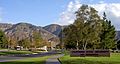
The Inland Empire is next to the San Bernardino Mountains. Lakes like Lake Arrowhead and Big Bear are in these mountains. Lake Arrowhead is popular in summer, while Big Bear is popular in winter for skiing and snowboarding.
Many places in the Inland Empire offer cultural performances and entertainment. The Victoria Gardens Cultural Center in Rancho Cucamonga opened in 2006. It hosts theater, concerts, and family shows. The San Manuel Amphitheater in San Bernardino is the largest outdoor amphitheater in the nation. San Bernardino's "Route 66 Rendezvous" is a yearly street fair and classic car show. It attracts half a million people from all over the world. The Palm Springs Aerial Tramway in Palm Springs is a popular attraction. It goes up to over 8,500 feet (2,591 meters) high.
Music Scene

Well-known bands from the IE include Alien Ant Farm, Hepcat, and the Voodoo Glow Skulls from Riverside. Cracker is from Redlands, and The Mountain Goats are from Chino. Many local hip-hop artists have also brought attention to the growing Hip hop community here. The "Jerkin'" street dance style started with Inland Empire hip-hop groups like New Boyz. Some artists linked to the Palm Desert Scene helped create "desert rock" and "stoner rock" music styles.
Famous musician Frank Zappa performed in Upland in the early 1960s. He also bought a recording studio in Rancho Cucamonga. He called it Studio Z and made recordings that led to his band, The Mothers of Invention.
From the late 1980s to the late 1990s, many rising musical acts played in Riverside. These included Rage Against the Machine, Blink-182, and No Doubt. Some of these historic music venues have since closed. New music venues are emerging in the IE, like the Vault in Redlands and the Glass House in Pomona.
Performing Arts

Orchestras in the IE include the Redlands Symphony and the Riverside County Philharmonic. The San Bernardino Symphony performs at the California Theatre. Theatrical Arts International also presents big touring shows like Cats and Hairspray at the California Theatre.
The Riverside Fox Theater, also known as the Fox Performing Arts Center, was built in 1929. It's a Spanish Colonial Revival style building in downtown Riverside. It was renovated and reopened in 2010 as a regional performing arts center. Chaffey High School in Ontario has a large theater program. The Inland Empire Harmony Carousel Chorus performs Barbershop Quartet music.
Sports and Recreation

The Inland Empire is the largest metropolitan area in the U.S. without a major professional sports team. However, it's part of the Greater Los Angeles area, which has teams in Los Angeles and Orange counties. The IE is home to many minor league baseball, basketball, and ice hockey teams. The Inland Empire 66ers baseball team won their most recent championship in 2013.
The Auto Club Speedway in Fontana opened in 1997. It has tracks for auto racing. It's close to where the old Ontario Motor Speedway used to be, which is now the site of the Toyota Arena.
| Club | League | Sport | Venue | Founded | Titles |
|---|---|---|---|---|---|
| Inland Empire 66ers | Low-A West | Baseball | San Manuel Stadium | 1941 | 6 |
| Lake Elsinore Storm | Low-A West | Baseball | Lake Elsinore Diamond | 1994 | 2 |
| Rancho Cucamonga Quakes | Low-A West | Baseball | LoanMart Field | 1993 | 1 |
| High Desert Yardbirds | Pecos League | Baseball | Stater Bros. Stadium in Adelanto | 2017 | 0 |
| Ontario Clippers | NBA G League | Basketball | Toyota Arena | 2017 | 0 |
| Ontario Reign | American Hockey League | Ice hockey | Toyota Arena | 2015 | 0 |
| Ontario Fury | MASL | Indoor soccer | Toyota Arena | 2013 | 0 |
| SoCal SC | NPSL | Soccer | San Bernardino Soccer Complex | 2016 | 0 |
| Redlands FC | USL2 | Soccer | Dodge Stadium | 2022 | 0 |
For college sports, the Inland Empire has five four-year schools. They compete in different NCAA divisions and the NAIA.
| Program | School | Location | Division | Main conference |
|---|---|---|---|---|
| California Baptist Lancers | California Baptist University | Riverside | NCAA Division I | Western Athletic Conference |
| UC Riverside Highlanders | University of California, Riverside | Riverside | NCAA Division I | Big West Conference |
| Cal State San Bernardino Coyotes | California State University, San Bernardino | San Bernardino | NCAA Division II | California Collegiate Athletic Association |
| Redlands Bulldogs | University of Redlands | Redlands | NCAA Division III | Southern California Intercollegiate Athletic Conference |
| La Sierra Golden Eagles | La Sierra University | Riverside | NAIA | California Pacific Conference |
Media and Communication
Newspapers
The Inland Empire has several local newspapers:
- The InlandEmpirePress.com provides online news for the Riverside County & San Bernardino Valley region.
- The San Bernardino County Sun mainly covers the San Bernardino Valley.
- The Inland Valley Daily Bulletin covers southwestern San Bernardino County and eastern Los Angeles County cities.
- The Riverside-based Press-Enterprise also has editions across the area.
There is also an Inland Empire edition of the Los Angeles Times.
Radio Stations
The Inland Empire is ranked 26th in the national radio market on its own. When combined with the Greater Los Angeles Area, it's part of the second largest radio market.
| Format stations | Public and college | Talk radio |
|---|---|---|
| KOLA-FM 99.9 Classics | KVCR-FM 91.9 NPR | KCAA-AM 1050 NBC Radio |
| KFRG-FM 95.1 Country | KUCR-FM 88.3 UC Riverside | KTIE-AM 590 Conservative talk |
| KHTI-FM 103.9 Adult Top 40 | ||
| KCAL-FM 96.7 Rock | KUOR-FM 89.1 NPR | KMET-AM 1490 Conservative |
| KGGI-FM 99.1 Hip-Hop/R&B | ||
| KLRD-FM 90.1 Christian contemporary |
Because of the mountains, it can sometimes be hard to get a clear radio signal across the whole Inland Empire.
Television and Film
PBS station KVCR-TV broadcasts directly to the Inland Empire. It covers all of Riverside and San Bernardino counties. Its sister station, First Nations Experience (FNX), shows programs about indigenous peoples.
The TV show Dr. Pimple Popper is filmed mainly at a clinic in Upland.
While there are no big film studios in the Inland Empire, filming here brought in $65.2 million in 2006. Some famous movies shot in the Inland Empire include Erin Brockovich and The Fast and the Furious. Scenes from other films like Constantine were also shot in the ghost town of Eagle Mountain.
The 2006 film Inland Empire is named after the region, but no scenes were actually filmed here. The TV series Breaking Bad producers wanted to film in the Inland Empire but chose New Mexico because of tax benefits. The movie Shot Caller (2017) has scenes set in the Inland Empire.
Images for kids
-
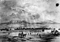
Drawing of San Bernardino (1852)
-
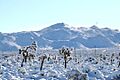
Yucca Valley, located in the Morongo Basin, is between the San Bernardino Valley and the Arizona state line.
-
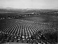
Arlington Heights Citrus Groves, Riverside circa 1903
-
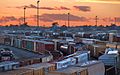
Boxcars, Rialto, California
-
Housing construction in Fontana, looking northeast along Interstate 15 during 2007. Since 1980, the city's population has grown by 170,000.
-
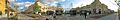
Panorama of the "Town Square" at Victoria Gardens in Rancho Cucamonga
-
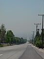
The Inland Empire often has smog, as seen here from Rancho Cucamonga. The street "fades" into the haze, and the Santa Ana Mountains are hidden.
-
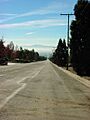
Sometimes, Santa Ana Winds bring clear days without smog. The street and mountains that were hidden are now visible.
-
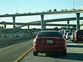
I-10–I-215 Interchange traffic, south of downtown San Bernardino
-
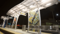
sbX Green Line's Civic Center station in downtown San Bernardino
-
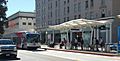
sbX Hospitality West Station, downtown San Bernardino
-
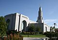
The Redlands California Temple is one of four LDS temples in Southern California.
-
California State University, San Bernardino
-
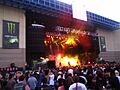
Lamb of God playing at Ozzfest at the San Manuel Amphitheater in Devore, San Bernardino, 2007
-
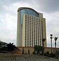
At 330 feet (100 m) high, the Morongo Casino, Resort & Spa tower is the tallest building in the Inland Empire. Concerts and events are booked inside.
-
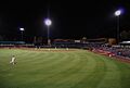
Inland Empire 66ers playing at San Manuel Stadium in downtown San Bernardino


See also
 In Spanish: Inland Empire (California) para niños
