
Yucca Valley, California facts for kids
Quick facts for kids
Yucca Valley, California
|
|||
|---|---|---|---|
.jpg)  View of Yucca Valley (left) and St. Mary of the Valley Church (right).
|
|||
|
|||

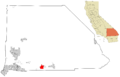
Location in San Bernardino County and the state of California
|
|||
| Country | United States | ||
| State | California | ||
| County | San Bernardino | ||
| Incorporated | November 27, 1991 | ||
| Government | |||
| • Type | Council-Manager | ||
| Area | |||
| • Total | 39.83 sq mi (103.16 km2) | ||
| • Land | 39.83 sq mi (103.16 km2) | ||
| • Water | 0.00 sq mi (0.00 km2) 0% | ||
| Elevation | 3,258 ft (993 m) | ||
| Population
(2020)
|
|||
| • Total | 21,738 | ||
| • Density | 545.8/sq mi (210.7/km2) | ||
| Time zone | UTC-8 (Pacific Time Zone) | ||
| • Summer (DST) | UTC-7 (PDT) | ||
| ZIP codes |
92284–92286
|
||
| Area codes | 442/760 | ||
| FIPS code | 06-87056 | ||
| GNIS feature IDs | 2413524 | ||


Yucca Valley is a town in San Bernardino County, California. It is an official town in the United States. In 2020, about 21,738 people lived there.
Yucca Valley is about 20 miles (32 km) north of Palm Springs. It is also about 49 miles (79 km) east of San Bernardino. The town is next to Joshua Tree National Park on its south side. The San Bernardino Mountains are to its west. Yucca Valley is in the Mojave Desert, about 3,300 feet (1,000 m) above sea level.
Contents
History of Yucca Valley
Native American people lived in the Yucca Valley area a long time ago.
Early Development and Famous Residents
In the late 1950s, Norman J. Essig helped make Yucca Valley a private place. Many famous people came to live there. He bought a lot of land and ran Glenn Realty. He also helped build the main roads in town. These roads connect to Highway 62.
Norman Essig was friends with Jimmy Van Heusen, a famous composer. He gave Van Heusen a great piece of land in Yucca Valley. Van Heusen built his house on the highest hill in the town. You can still see it today.
Earthquakes and Wildfires
Yucca Valley has experienced several large earthquakes. In 1992, three big earthquakes happened nearby. These were the Joshua Tree earthquake (magnitude 6.1) on April 22. Then, on June 28, the Landers earthquake (magnitude 7.3) and the Big Bear earthquake (magnitude 6.5) occurred.
Another strong earthquake, the Hector Mine earthquake, happened on October 16, 1999. It had a magnitude of 7.1. Its center was about 30 miles (48 km) north of Yucca Valley.
On July 11, 2006, a wildfire started by lightning. It spread through nearby Pioneertown. This fire was called the Sawtooth Complex fire. It also burned parts of Yucca Valley and Morongo Valley. The fire destroyed about 64,000 acres (26,000 ha) of desert land.
Geography and Climate

Yucca Valley is in the middle of the Morongo Basin. Its base elevation is about 3,300 feet. Joshua Tree National Park is right next to its southern border.
Land Area and Mountains
The town covers about 40.0 square miles (104 km2) of land. There is no water area within the town limits. Yucca Valley is north of Joshua Tree National Park. The Little San Bernardino Mountains and many hills cover a large part of the town.
The town hall is about 3,224 feet (983 m) above sea level. Snow often falls almost every year when the snow level drops below 4,000 feet (1,200 m).
Wildfire Risks and Earthquakes
The area's land can have wildfires. This happens because plants grow a lot during rainy seasons. Then, they dry out in the summer heat. This dry plant material can easily catch fire. Flash floods can also happen here.
Yucca Valley has a lot of earthquake activity. Many fault lines cross through the town and the Morongo Basin.
Weather Patterns
Yucca Valley has a cold desert climate. This type of climate is known as "BWk" on climate maps. It means the area is a desert, but it can get cold.
| Climate data for Yucca Valley, CA | |||||||||||||
|---|---|---|---|---|---|---|---|---|---|---|---|---|---|
| Month | Jan | Feb | Mar | Apr | May | Jun | Jul | Aug | Sep | Oct | Nov | Dec | Year |
| Mean daily maximum °F (°C) | 61.1 (16.2) |
61.1 (16.2) |
69.1 (20.6) |
74.4 (23.6) |
86.3 (30.2) |
92.3 (33.5) |
102.0 (38.9) |
99.0 (37.2) |
95.8 (35.4) |
80.1 (26.7) |
70.1 (21.2) |
58.3 (14.6) |
79.13 (26.18) |
| Mean daily minimum °F (°C) | 38.5 (3.6) |
38.8 (3.8) |
40.2 (4.6) |
44.4 (6.9) |
54.1 (12.3) |
59.9 (15.5) |
71.6 (22.0) |
67.5 (19.7) |
64.1 (17.8) |
52.8 (11.6) |
43.9 (6.6) |
36.3 (2.4) |
51.01 (10.56) |
| Average precipitation inches (mm) | 0.7 (18) |
0.5 (13) |
0.4 (10) |
0.1 (2.5) |
0.2 (5.1) |
0 (0) |
0.3 (7.6) |
0.4 (10) |
0.4 (10) |
0.4 (10) |
0.6 (15) |
0.8 (20) |
4.8 (120) |
| Source: Weatherbase | |||||||||||||
Population and People
| Historical population | |||
|---|---|---|---|
| Census | Pop. | %± | |
| 1970 | 3,893 | — | |
| 1980 | 8,294 | 113.0% | |
| 1990 | 13,701 | 65.2% | |
| 2000 | 16,865 | 23.1% | |
| 2010 | 20,700 | 22.7% | |
| 2020 | 21,738 | 5.0% | |
| U.S. Decennial Census | |||
Population in 2010
The 2010 United States Census counted 20,700 people in Yucca Valley. Most people (83.5%) were White. About 17.8% of the population was Hispanic or Latino.
About 98.9% of the people lived in regular homes. There were 8,274 households. About 30.4% of these homes had children under 18. The average household had 2.48 people.
The population was spread out by age. About 23.9% were under 18. About 18.5% were 65 or older. The average age in Yucca Valley was 40.6 years.
Most homes (63.5%) were owned by the people living in them. The rest were rented.
Population in 2000
In the census of 2000, Yucca Valley had 16,865 people. There were 6,949 households. About 27.9% of these homes had children under 18.
About 25.1% of the people were under 18. About 22.8% were 65 or older. The average age was 42 years.
Economy and Jobs
Local Income
In 2000, the average income for a household in Yucca Valley was $30,420. For families, it was $36,650. The average income per person was $16,020. This was lower than many other places in Southern California.
About 19.5% of the people lived below the poverty line. This included 27.3% of those under 18.
Employment Opportunities
The Twentynine Palms Base of the US Marine Corps is about 20 miles east of Yucca Valley. Many people who live in the Morongo Basin work at this base.
Things to Do and See

Yucca Valley is right next to Joshua Tree National Park. This park is a popular place to visit.
The town has fun places like a bowling alley. There are also many shops. The "Old Town" area is a nice place to explore. The Sky Village weekend open-air market is also very popular. On Grubstakes Day, which is the day before Memorial Day, there is a parade.
Old Town Yucca Valley is on Highway 62. It is at the corner of Pioneertown Road. The California Welcome Center is at 56711 Twentynine Palms Highway. It gives visitors information about places to stay, eat, and have fun.
Yucca Valley is home to the Desert Christ Park sculpture garden. It also has a large geoglyph called "Atlatl." This artwork was made by artist Andrew Rogers.
Education in Yucca Valley
Public schools in Yucca Valley are managed by the Morongo Unified School District.
Public Schools
Yucca Valley has three elementary schools:
- Onaga Elementary
- Yucca Mesa Elementary
- Yucca Valley (Hope) Elementary
There is one middle school:
- La Contenta Middle School
There are two high schools:
- Yucca Valley High School
- Black Rock Continuation High School
Private Schools
Several private schools are also in Yucca Valley:
- Our Lady of the Desert: A Christian school for grades K–12.
- Valley Community Chapel School and Daycare: Offers Preschool, Kindergarten, and before/after school daycare.
- Joshua Springs Christian School: A non-denominational school for PK–12.
- Grace Christian School: A Brethren school for K–12.
- Hi-Desert SDA Elementary: A Seventh Day Adventist school for grades 1–6.
- Yucca Valley Christian School: Affiliated with The Assembly of God, for PK–12.
Hope Academy used to be a charter school but closed in 2016. If you need help with school, adult tutoring is available at the Yucca Valley Public Library.
Transportation and Travel
Yucca Valley has two main highways. California State Route 62 (Twentynine Palms Highway) goes east and west. It is the main road through town. It ends at Interstate 10 and Parker Dam on the Arizona border.
California State Route 247 (Old Woman Springs Road) starts in Yucca Valley. It goes north through Barstow and ends at Interstate 15.
Bus and Air Travel
Basin Transit provides bus service around town and the lower desert. You can take these buses to connect to Palm Springs International Airport. From there, you can get direct buses to Los Angeles. The Yucca Valley Airport serves the local area for air travel.
Media and Communication
Newspapers and Radio
The local newspaper is the Hi Desert Star. It comes out every two weeks.
Several radio stations have studios in the Coachella Valley (near Palm Springs). They broadcast to the Morongo Basin. These include:
- 91.7 KHCS (Christian)
- 92.1 KXCM (country)
- 94.3 KNWZ "K-News" on 103.7 FM and 1250 AM
- 106.9 KDGL (70s-90s hits)
- 106.1 KPLM (country)
There is one local station, 107.7 KCDZ (z107). Its studios are in Joshua Tree.
Television and Internet
The county runs several television repeaters. These broadcast signals from Palm Springs, Riverside/San Bernardino, and Greater Los Angeles. You can receive these signals in the Yucca Mesa area.
Charter Spectrum provides television service and high-speed cable internet in town. Other companies offer wireless internet service (WISP). These include Mojave WiFi, Frontier, and Flashbyte Digital.
Images for kids
-
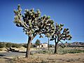
View of Yucca Valley
-
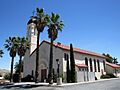
St. Mary of the Valley Church
-
Flag of Yucca Valley
-
Seal of Yucca Valley
-
Map of Yucca Valley's location
See also
 In Spanish: Yucca Valley para niños
