
Devore, San Bernardino facts for kids
Quick facts for kids
Devore
|
|
|---|---|
| Devore Heights | |
_(crop)-01.jpg)
Roadside business in Devore along former historic U.S. Route 66 (Cajon Boulevard)
|
|

Devore
Location in California

Devore
Location in the United States
|
|
| Country | United States |
| State | California |
| County | San Bernardino County |
| City | San Bernardino |
| Elevation | 2,510 ft (770 m) |
| Time zone | UTC-8 (Pacific (PST)) |
| • Summer (DST) | UTC-7 (PDT) |
| ZIP codes |
92407
|
| Area code(s) | 909 and 840 |
| GNIS feature ID | 270868 |
Devore Heights, often called Devore, is a quiet, countryside neighborhood. It is part of the city of San Bernardino in California. You can find it north of where Interstate 15 and Interstate 215 meet. This area is about 12 miles northwest of downtown San Bernardino.
Devore is the last community you pass before heading up the Cajon Pass to reach Hesperia, California. It sits just outside the San Bernardino National Forest. Nearby places include Verdemont, University Hills, Rancho Cucamonga, Fontana, and Rialto. The Glen Helen Amphitheater, North America's largest outdoor concert venue, is just south of Devore. Devore uses the 92407 ZIP Code and the 909 and 840 area codes.
Contents
History of Devore
Devore is located in the northern part of what was once the Muscupiabe Rancho. It's a community in the foothills of the San Bernardino Mountains. It sits between the Cajon Pass and the valley cities. The area also includes some private lands within the National Forest.
The San Andreas Fault, a major earthquake fault line, runs through the hills above Devore. Other fault lines, like the Glen Helen and San Jacinto Faults, are found in the Cajon Creek/Wash area below Devore. Smaller earthquake rifts, such as the Peters Fault, can also cause tremors here.
The name of this area changed many times over the years. It was called El Cajon de Muscupiabe and Rancho Muscupiabe in 1858. Later names included The Martin District (1887), The Guernsey Tract (1895), The Glen Helen Tract (1901), and Kenwood Heights (1903). Finally, it became known as Devore around 1904. For many years, people called Devore "The Southern Portal of the Cajon Pass."
Early Settlers and Land Owners
Michael White arrived in the US in 1817. He received the Muscupiabe land grant in 1842. By then, he was a Mexican citizen and had married into a well-known Hispanic family. His Spanish name was Don Miguel Blanco. He lived in Cable Canyon and was tasked with watching the pass for horse thieves. In 1855, he sold half of his land. Two years later, the Whites sold the rest to Henry Hancock, who had surveyed the Rancho.
John A. Devore worked for the Kenwood Corporation, a clothing company. In 1901, he came to Southern California to work with the railroads. He bought land from John and Nettie (Hawley) Cole and also from John M.C. and Elizabeth Marble.
In 1902, the Kenwood Corporation planned to develop the Devore property. They wanted to plant orchards and vineyards. However, the company went bankrupt in 1904. For $1,000, the land was transferred to John A. Devore in 1905.
John Devore passed away young in 1907. He had a vision for Devore to be a place of beauty. He designed lovely homes, rock walls, and gardens. Sadly, much of his work was destroyed by a big flood in 1938.
By 1910, much of the land was transferred to new owners. The Devore Land Company was then created.
Canyons and Their Names
The Devore area has many canyons formed by water flows from the mountains. These canyons are often named after early landowners.
- Cable Canyon was named after two brothers, the Cable brothers. They had a ranch there and were active in local politics in the 1870s.
- Hopper Canyon got its name from Henry and Julia (Akers) Hopper. They settled in the area with their seven children.
- Akers Canyon was named for Julia’s father, Larkin B. Akers, or other Akers family members who farmed there.
- Middleman Falls was named after James Petty Medlin, a farmer from New York. His name was often mispronounced as Middleman. He had many water rights but was sadly murdered in 1895.
- Wilson Creek was named after Robert N.C. Wilson. He was involved in land and water dealings in the area in 1883.
- Pittman Canyon was named for Dr. Henderson Pittman, who bought property there in 1913.
- Ames Canyon was named for Robert Earl Ames, an early settler who came with the Mormons.
Other early settler names include Swarthout (farmers), Cleghorn (lumber cutters), and John Hansen.
Mining and Development
Most of the mining claims in Devore were for useful materials, not gold. People mined asbestos, calcite, talc, and clay. John Devore bought some claims for calcite. Calcite (lime) was important for making cement before it was shipped from Europe. Kilns in the Kimbark Canyons were used to process these materials.
In 1915, Theodore and Harriet Walker bought more than half of Devore. Their relatives, Mr. and Mrs. R.K. Walker, also bought land, including the Devore Ranch. Mrs. R.K. Walker became well-known for her flowers and produce. Robert B. Peters, whose wife was the daughter of the Theodore Walkers, also bought land in Devore. He later bought the Devore Ranch and helped form the Mesa Alta Orange Company.
The Devore Water Company was established in 1904. It still provides water to the community today.
Devore Depot
The Devore Station was a strong building made of concrete and rock. It was more decorative than other train stations along the Cajon Pass. This two-story building was designed by architect Harrison Allbright. It was used from 1908 to 1930 and torn down around 1958. The upstairs office was used by the Station Master, Herbert B. Davis, and his wife, Jennie Cook Davis, who was the postmistress and a local poet.
Education in Devore
Devore is part of the San Bernardino City Unified School District. The neighborhood is home to Kimbark Elementary School, which was recognized as a California Gold Ribbon School in 2016. Kimbark School opened in 1968.
Before Kimbark, there was Cajon School. This school was built in 1924 from local rocks by Devore residents. It was a large room that could be divided into two. In 1949, a four-room addition was built for students up to sixth grade. An even older Cajon School existed from 1870 to 1921.
Local Attractions
Devore has some exciting places to visit!
- Glen Helen Amphitheater is a huge outdoor venue for music concerts and festivals. It opened in 1982 and can hold up to 65,000 people. This makes it the largest outdoor amphitheater in North America! Most amphitheaters hold between 10,000 and 25,000 people.
- Mountain High is a ski resort located in Wrightwood. It's open in the colder months for snow sports like skiing and snowboarding.
- Local attractions of Devore
-
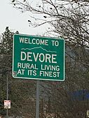
Devore City Sign
-
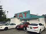
Papa Tony's Diner
-
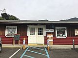
Mom's Country Store


The Old Fire
Devore was greatly affected by a large wildfire called The Old Fire. It started on October 25, 2003. The fire quickly grew to cover a huge area, burning over 91,000 acres of land. It destroyed 940 homes, 30 businesses, and 300 other buildings. More than 4,000 firefighters worked hard to put out the blaze.
The Old Fire spread towards the San Bernardino Mountains. It even merged with another fire, the Grand Prix Fire, across the Interstate 15 Freeway. Together, these fires caused damage across more than 30 miles. This fire was a major event for Devore, which was still recovering from the Panorama Fire that happened in 1980. The Old Fire led to a tragic loss of life and forced over 70,000 people to leave their homes for safety.
See also
 In Spanish: Devore (California) para niños
