
Image: United States 1863-03-1863-06

Size of this preview: 800 × 542 pixels. Other resolutions: 320 × 217 pixels | 1,000 × 677 pixels.
Original image (1,000 × 677 pixels, file size: 51 KB, MIME type: image/png)
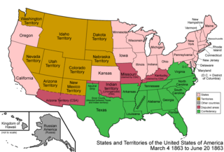
Description: Map of the states and territories of the United States as it was from March 1863 to June 1863. On March 4 1863, Idaho Territory was created from portions of Washington, Dakota, and Nebraska Territories. On June 20 1863, several counties of Virginia split to join the Union, and were admitted as the state of West Virginia.
Title: United States 1863-03-1863-06
Credit: Own work
Author: Made by User:Golbez.
Permission: Own work, attribution required (Multi-license with GFDL and Creative Commons CC-BY 2.5)
Usage Terms: Creative Commons Attribution 2.5
License: CC BY 2.5
License Link: https://creativecommons.org/licenses/by/2.5
Attribution Required?: Yes
Image usage
The following 3 pages link to this image:

All content from Kiddle encyclopedia articles (including the article images and facts) can be freely used under Attribution-ShareAlike license, unless stated otherwise.