
Outline of Wyoming territorial evolution facts for kids
The land that is now Wyoming has a long and interesting history. It wasn't always part of the United States. Over hundreds of years, different countries and groups claimed this land. This article will show you how Wyoming's borders changed and how it became the state we know today.
Contents
Early Claims by European Powers
Before the United States existed, European countries explored and claimed vast areas of North America. The land that would become Wyoming was part of these claims.
Spain's Influence
Spain was one of the first European countries to claim parts of what is now Wyoming. They called some areas Nueva Vizcaya and Santa Fé de Nuevo Méjico. These claims lasted from the late 1500s until 1821. Spain also claimed a large area known as the Gran Cuenca. Spain's control ended with the Treaty of Córdoba in 1821, when Mexico gained independence.
France's Claim: Louisiana
France also claimed a huge territory called Louisiane, which included parts of present-day Wyoming. This claim started in 1682. However, in 1762, France secretly gave this vast territory to Spain through the Treaty of Fontainebleau.
Spain Regains Louisiana
So, for a time, Spain controlled the Louisiana territory. But this didn't last forever. In 1800, Spain secretly gave Louisiana back to France with the Third Treaty of San Ildefonso.
France Sells Louisiana to the U.S.
Just three years later, in 1803, France sold the entire Louisiana territory to the United States in a huge deal called the Louisiana Purchase. This purchase greatly expanded the size of the young United States, adding a massive amount of land, including much of what is now Wyoming.
Even after the Louisiana Purchase, some parts of Wyoming were still claimed by other nations or were considered "unorganized."
The Oregon Country
From 1818 to 1846, a large area called the Oregon Country was shared by the United States and Great Britain. This area included parts of western Wyoming. People living there even formed their own temporary government. In 1846, the Oregon Treaty finally settled the border, giving the southern part of Oregon Country, including the Wyoming portion, to the United States.
Mexico's Claims
After Mexico became independent from Spain in 1821, it inherited some of Spain's claims. Mexico claimed parts of Wyoming as part of Santa Fé de Nuevo México and the Gran Cuenca. These claims ended in 1848 after the Mexican–American War. The Treaty of Guadalupe Hidalgo officially transferred these lands to the United States.
Texas's Disputed Strip
For a short time, the Republic of Texas (which was an independent country before joining the U.S.) claimed a strip of land that stretched north into present-day Wyoming. This was a disputed area. When Texas joined the United States in 1845, this claim became part of the larger U.S. territory.
Becoming a U.S. Territory
As the United States grew, it organized its new lands into territories before they could become states.
Early U.S. Territories
- Unorganized Territory (1803-1804): Right after the Louisiana Purchase, the land was simply "unorganized."
- District of Louisiana (1804-1805): The U.S. quickly organized it into a district.
- Territory of Louisiana (1805-1812): This district soon became a full territory.
- Territory of Missouri (1812-1821): As more people moved west, the Territory of Louisiana was renamed the Territory of Missouri.
- Unorganized Territory (1821-1854): After Missouri became a state, a large western part of the Missouri Territory, including much of Wyoming, became "unorganized" again.
New Territories Emerge
- Territory of Oregon (1848-1859): After the Oregon Treaty, the Territory of Oregon was created, covering parts of western Wyoming.
- State of Deseret (1849-1850): A group of settlers tried to create their own state called State of Deseret in this region, but it was never officially recognized by the U.S. government.
- Territory of Utah (1850-1896): Instead, the Territory of Utah was formed, which included a large part of western Wyoming.
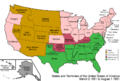
- Territory of Nebraska (1854-1867): The Territory of Nebraska was created, covering much of eastern Wyoming.
- Territory of Washington (1853-1889): A small part of northwestern Wyoming was briefly part of the Territory of Washington.
- Territory of Jefferson (1859-1861): Another unofficial territory, the Territory of Jefferson, was proposed by settlers in the area that would become Colorado, also including a small part of Wyoming.
- Territory of Dakota (1861-1889): The Territory of Dakota was formed, taking over some of the land previously in Nebraska Territory.
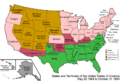
- Territory of Idaho (1863-1890): The Territory of Idaho was created, and for a time, it included a significant portion of western Wyoming.
The Wyoming Territory
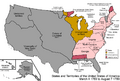
Finally, in 1868, the Territory of Wyoming was officially created by the U.S. Congress. This territory was made up of parts from the Dakota, Utah, and Idaho territories. This was the last step before becoming a state.
Wyoming Becomes a State
After more than two decades as a territory, Wyoming had enough people and was ready to join the United States as a full state. On July 10, 1890, Wyoming officially became the 44th state in the Union. Its borders have remained the same ever since.
Images for kids
-
An enlargeable map of the United States after the Constitution of the United States was ratified on March 4, 1789.
-
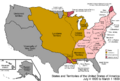
An enlargeable map of the United States after the secret Third Treaty of San Ildefonso transferred the Spanish colony of la Luisiana to the French Republic on October 1, 1800.
-
An enlargeable map of the United States after the Louisiana Purchase took effect on December 20,1803.
-
An enlargeable map of the United States after the creation of the District of Louisiana on March 26, 1804.
-
An enlargeable map of the United States after the creation of the Territory of Louisiana on March 3, 1805.
-
An enlargeable map of the United States after the creation of the Territory of Missouri on June 4, 1812.
-
An enlargeable map of the United States after the Treaty of 1818 took effect on October 20, 1818.
-
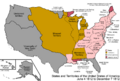
An enlargeable map of the United States after the Adams–Onís Treaty took effect on February 22, 1821.
-
Territorial claims of the Republic of Texas, May 2, 1836.
-
An enlargeable map of the United States after the Oregon Treaty took effect July 17, 1846
-
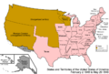
An enlargeable map of the United States after the Treaty of Guadalupe Hidalgo was signed on February 2, 1848.
-
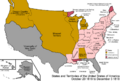
An enlargeable map of the United States after the creation of the Territory of Oregon on August 14, 1848.
-
An enlargeable map of the United States after the creation of the proposed State of Deseret on July 2, 1849.
-
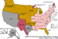
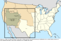
An enlargeable map of the United States after the creation of the Territory of New Mexico and the Territory of Utah on September 9, 1850.
-
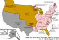
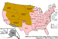
An enlargeable map of the United States after the creation of the Territory of Kansas and the Territory of Nebraska on May 30, 1854.
-
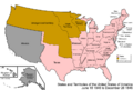
An enlargeable map of the United States after the creation of the proposed Territory of Jefferson on October 24, 1859.
-
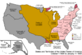
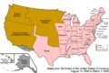
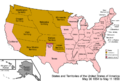
An enlargeable map of the United States after the creation of the Territory of Dakota on March 2, 1861.
-

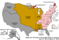
An enlargeable map of the United States after the creation of the Territory of Idaho on March 3, 1863.
-
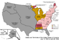
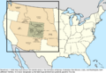
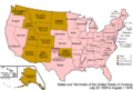
An enlargeable map of the United States after the creation of the Territory of Montana on May 26, 1864.
-
An enlargeable map of the United States after the creation of the Territory of Wyoming on July 25, 1868.


