
Image: WestPacGeol

Size of this preview: 442 × 600 pixels. Other resolutions: 177 × 240 pixels | 454 × 616 pixels.
Original image (454 × 616 pixels, file size: 156 KB, MIME type: image/jpeg)
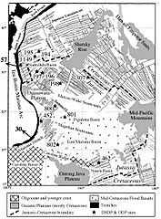
Description: Simplified geologic and magnetic map of the western Pacific, based on the work of Nakanishi 1992. Relative motion of the Pacific Plate with respect to the Philippine Sea Plate is shown with arrows, numbers correspond to velocities (mm/year), after Seno, Stein & Gripp 1993. Numbers with asterisks represent scientific drilling sites, especially Ocean Drilling Project and Deep Sea Drilling Program drillsites.
Title: WestPacGeol
Credit: Zyzzy2 (talk) (Uploads)
Author: Zyzzy2 (talk) (Uploads)
Usage Terms: Public domain
License: PD
Attribution Required?: No
Image usage
The following 2 pages link to this image:

All content from Kiddle encyclopedia articles (including the article images and facts) can be freely used under Attribution-ShareAlike license, unless stated otherwise.