Izu–Bonin–Mariana Arc facts for kids
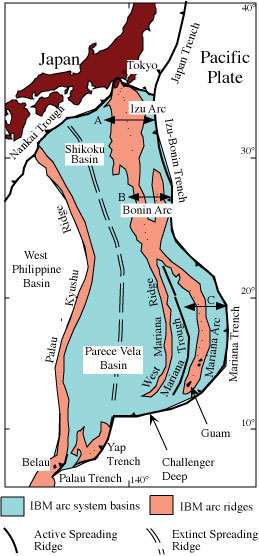
The Izu–Bonin–Mariana (IBM) arc system is a huge chain of islands and underwater mountains in the Pacific Ocean. It's a special place where two of Earth's giant plates, called tectonic plates, are crashing into each other. This system stretches over 2,800 km (about 1,700 miles) from Tokyo, Japan, all the way past Guam. It includes the Izu Islands, the Bonin Islands, and the Mariana Islands. Most of this amazing system is hidden deep under the ocean.
The IBM arc system sits on the eastern edge of the Philippine Sea Plate in the Western Pacific. It's home to the deepest spot on Earth's surface, called the Challenger Deep, which is found in the Mariana Trench.
This arc system formed because the western Pacific plate is slowly sliding underneath the Philippine Sea Plate. This process is called subduction. The Pacific plate here is very old, with some parts being about 170 million years old! The speed at which the plate slides varies, from about 2 cm (1 inch) per year in the south to 6 cm (2.5 inches) per year in the north.
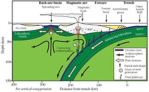
The volcanic islands you see in these arcs are created when water and other gases are released from the sinking plate. As the plate goes deeper, it gets hotter, and these gases escape, fueling volcanoes. The deep trenches form because the oldest part of the Pacific plate gets very dense and heavy, causing it to sink to its lowest point just before it slides under the other plate.
The IBM arc system is a great example of an "intra-oceanic convergent margin." This means it's built on oceanic crust (the seafloor), unlike other island arcs like Japan or the Andes mountains, which are built on thicker continental crust. Studying the IBM system helps scientists understand how Earth's mantle (the layer below the crust) interacts with the crust. It also helps us learn how important ore deposits (like metal veins) are formed deep within the Earth.
Contents
- Where is the IBM Arc System?
- How Do the Plates Move?
- History of the IBM Arc System
- Parts of the IBM Arc System
- What Happens to the Pacific Plate?
- Rocks and Sediments of the Western Pacific Plate
- Earthquakes and the Deep Earth
- Volcanoes and Hot Springs in the Mariana Arc
- Historical Importance of the IBM Arc System
- See also
Where is the IBM Arc System?
The IBM arc system has been forming for about 50 million years. Its boundaries show where this huge geological process is happening. The northern part of the IBM arc connects with the Nankai Trough near Japan. It also meets the Japan Trench and the Sagami Trough at a special spot called the Boso Triple Junction. This is one of only two places on Earth where three ocean trenches meet!
To the east, the IBM arc system is bordered by a very deep trench. This trench ranges from nearly 11 km (7 miles) deep in the Challenger Deep to less than 3 km (2 miles) deep in other areas. The southern boundary is near Belau, where the IBM Trench meets the Kyushu–Palau Ridge. So, the IBM arc system covers a huge area, stretching across 25 degrees of latitude!
How Do the Plates Move?
The IBM arc system is mostly part of the Philippine Sea Plate. Even though parts of it move internally, it's helpful to understand how the Philippine Sea Plate moves compared to its neighbors. The Philippine Sea Plate (PH) interacts with four other plates: the Pacific (PA), Eurasian (EU), North American (NA), and Caroline (CR) plates.
The Pacific Plate is slowly rotating around a point near the southern end of the Philippine Sea Plate. This means that in the south, the Pacific Plate is sliding under the IBM arc at about 20–30 mm (less than 2 inches) per year. In the north, it's moving twice as fast!
Interestingly, the IBM trench is not moving backwards into the ocean. Instead, it's moving towards Eurasia. This movement, combined with other forces, causes the area behind the arc to stretch and create new seafloor. This process is called "back-arc basin spreading."
History of the IBM Arc System
Scientists know a lot about how the IBM arc system has changed over time. Because it has always been an area where the crust is stretching, its different parts are spread out over a wide area. Generally, the oldest parts are found farthest to the west.
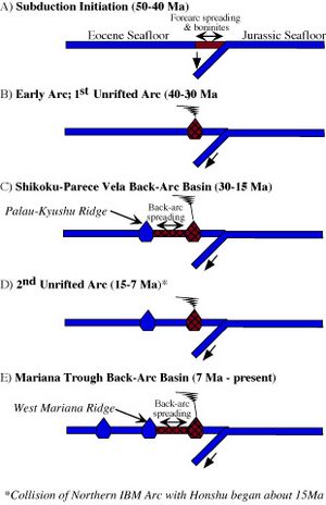
The IBM subduction zone began when old, heavy seafloor in the Western Pacific started to sink. This sinking process led to the formation of the volcanic arc, which has stayed close to its current position for a long time. Around 30 million years ago, the arc started to split apart, forming new ocean basins like the Parece Vela Basin and the Shikoku Basin. These basins grew, creating the largest "back-arc basin" on Earth!
During this splitting, the volcanoes were disrupted, but they started to grow again once new seafloor began to spread. About 15 million years ago, the northern part of the IBM arc began to collide with Japan.
A newer period of splitting began after 10 million years ago, forming the Mariana Trough back-arc basin. This means the volcanoes in the Mariana arc are relatively young, only about 3–4 million years old.
Parts of the IBM Arc System
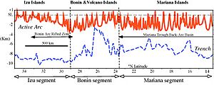
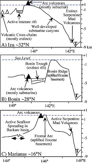
The IBM arc system is divided into three main parts: the Izu, Bonin, and Mariana segments. These segments have different features.
The forearc is the part of the arc system between the deep trench and the active volcanoes. The IBM forearc is about 200 km (124 miles) wide from Guam to Japan. Some parts of the forearc are uplifted, forming islands like those in the Marianas and the Bonin Islands. These islands are made of old volcanic rocks and coral reefs. There isn't much sediment piled up in the IBM forearc or trench.
The magmatic arc is where the active volcanoes are located. This chain of volcanoes is often underwater, sitting on a platform between 1 and 4 km (0.6 to 2.5 miles) deep. In the Izu segment, you'll find volcanic islands like O-shima and Miyakejima. The Bonin segment mostly has underwater volcanoes, though some, like Nishino-shima, rise above the sea. The highest points in the IBM arc are in the southern Bonin segment, where extinct volcanoes like Minami Iwo Jima and Kita Iwo Jima rise almost 1,000 m (3,280 feet) above sea level.
In the Marianas, the magmatic arc is mostly underwater north of Uracas. South of that, it includes volcanic islands like Asuncion, Maug, Pagan, and Anatahan.
The back-arc regions behind the volcanoes are also different in each segment. The Izu segment has several volcanic chains extending away from the main arc. The Bonin segment has no back-arc basin. But the Mariana segment has an active spreading back-arc basin called the Mariana Trough, where new seafloor is being created.
What Happens to the Pacific Plate?
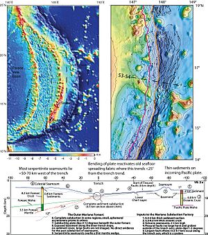
Everything on the Pacific plate that reaches the IBM trench eventually sinks into the Earth. The IBM trench is where the Pacific Plate starts its deep dive. This trench has very little sediment because the thin layer of sediments (about 400 m or 1,300 feet thick) is completely carried down with the sinking plate.
Just before the plate sinks, the seafloor rises into a gentle bump called the "outer trench swell." This swell is a few hundred meters high. The plate here becomes very cracked, allowing seawater to seep deep inside. This water can react with the mantle rocks, forming a mineral called serpentinite. This serpentinite can then carry water even deeper into the Earth's mantle as the plate subducts.
Rocks and Sediments of the Western Pacific Plate
The Pacific plate that sinks under the IBM arc system is made of rocks from the mid-Jurassic to early Cretaceous periods. This means it's very old! The northern part of the seafloor here is smooth, while the southern part is rugged, with many seamounts (underwater mountains) and islands. These differences tell us about their different geological histories.
Scientists can figure out the age of the seafloor by looking at magnetic patterns in the rocks, like "growth rings" of the Pacific Plate. The oldest magnetic patterns found here are incredibly ancient, some dating back to about 157 million years ago! Some rocks found by scientific drilling are even older, around 167 million years old. This makes the Western Pacific seafloor some of the oldest on Earth.
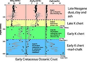
The sediments (like mud and sand) on this ancient seafloor are not very thick. They are mostly made of chert (a hard rock) and pelagic clay (fine clay from the deep ocean). There's not much carbonate (like shells) unless you're near underwater mountains.
The types of sediments sinking under the northern and southern parts of the IBM arc are different. In the south, there are thick layers of volcanic rocks from a period of intense volcanism during the Cretaceous. This volcanic activity was largely in the region south of 20°N latitude.
The image above shows typical sediments found east of the Izu–Bonin segment. These sediments are about 400 m (1,300 feet) thick and can be as old as 134 million years. They show layers of carbonate, chert, and clay.
Earthquakes and the Deep Earth
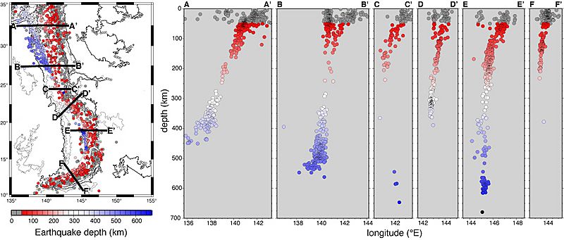
Studying seismicity (earthquake patterns) helps scientists understand the shape and behavior of the sinking plate, called a slab. The IBM arc system has a special zone of earthquakes called the Wadati–Benioff zone (WBZ).
Beneath the northern IBM, the WBZ gets steeper as you go south. Earthquakes become less frequent between about 150 km and 300 km deep. Beneath the central IBM, the sinking slab is almost vertical!
Deep earthquakes (more than 300 km deep) happen in parts of the IBM system, but they are less common than in other subduction zones. Scientists used to think these earthquakes happened at the very top of the sinking plate. However, newer studies show that many of them occur inside the slab. For example, some earthquakes happen about 20 km (12 miles) below the top of the sinking plate.
Sometimes, two parallel zones of earthquakes, called "double seismic zones" (DSZs), are found within the sinking slab. In the southern IBM, a DSZ was found between 80 km and 120 km deep. Scientists are still debating what causes these double zones, but it might be related to how the slab bends or changes its minerals under pressure.
Volcanoes and Hot Springs in the Mariana Arc
Scientists have found 76 volcanic structures along the Mariana arc, with at least 26 of them (20 underwater) being active with hot springs or eruptions. These active volcanoes are located 80 to 230 km (50 to 143 miles) above the sinking Pacific plate. There isn't a regular pattern to how far apart the volcanoes are.
Scientists believe that the hot springs (hydrothermal activity) in intra-oceanic arcs like the IBM system contribute about 10% of the total hot water emissions from all the mid-ocean ridges around the world.
Historical Importance of the IBM Arc System
The IBM arc system has played a role in human history:
- Ferdinand Magellan first landed on Guam in the southern IBM arc in 1521 after his long journey across the Pacific Ocean.
- The Bonin Islands were important stops for water and supplies for New England whaling ships in the early 1800s.
- Terrible battles were fought on the islands of Saipan and Iwo Jima during World War II in 1944 and 1945. Many soldiers from Japan and America lost their lives.
- George H. W. Bush, who later became a US President, was shot down in 1945 near Chichijima in the Bonin Islands.
- The B-29 bomber Enola Gay took off from Tinian in 1945 to drop the first atomic bomb on Hiroshima.
- Sergeant Shoichi Yokoi hid in the wilds of Guam for 28 years after World War II, finally coming out in 1972.
- The brown tree snake was accidentally brought to Guam during World War II and has since caused a lot of harm to the native birds there.
See also
 In Spanish: Arco de Izu-Bonin-Mariana para niños
- Mariana Trench
- Mariana Trough
- Mariana Islands
- South Chamorro Seamount
 | Aurelia Browder |
 | Nannie Helen Burroughs |
 | Michelle Alexander |


