
Okinotorishima facts for kids
 |
|
| Geography | |
|---|---|
| Location | Philippine Sea, Pacific Ocean |
| Coordinates | 20°25′N 136°05′E / 20.417°N 136.083°E |
| Area | 7.8 km2 (3.0 sq mi) |
| Highest elevation | 1.5 m (4.9 ft) |
| Administration | |
|
Japan
|
|
| Demographics | |
| Population | 0 |

Okinotorishima (沖ノ鳥島, Okinotori-shima) is a tiny, uninhabited island that belongs to Japan. It's located far out in the Philippine Sea, which is part of the big Pacific Ocean.
It's actually an atoll, which is a ring-shaped coral reef with a lagoon in the middle. This atoll is part of a long underwater mountain range called the Palau-Kyushu Ridge.
Island History
Okinotorishima is one of the many islands in the Pacific Ocean that are part of a group called the Ogasawara Islands. These islands are governed by Tokyo, Japan.
Japan says that the waters around Okinotorishima are its Exclusive Economic Zone (EEZ). An EEZ is a special area of the sea where a country has rights to explore and use marine resources. However, some other countries, like China, do not agree with Japan's claim over this specific EEZ.
Island Geography
The Japanese government officially says that Okinotorishima is Japan's southernmost island. It is located about 1,700 kilometers (about 1,056 miles) south of central Tokyo.
Okinotorishima is in a very important spot for military and shipping routes. It sits about halfway between Taiwan and Guam. This makes its location quite strategic in the Pacific Ocean.
Images for kids
-
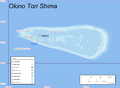
Map of Okinotorishima
-
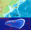
Location of Okinotorishima and details of the island
-
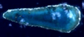
Satellite Image
-
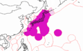
Exclusive economic zone of Japan. The lowermost purple near-circle is the area around Okinotorishima


See also
 In Spanish: Okinotorishima para niños
