
Iwo Jima facts for kids
|
Native name:
硫黄島
|
|
|---|---|

Photo of Iwo Jima (Iōtō), c. 2016, with Mount Suribachi in the lower left hand corner
|
|

Iōtō (Iwo Jima)
Location in Japan
|
|
| Geography | |
| Location | Pacific Ocean |
| Coordinates | 24°46′48″N 141°19′12″E / 24.78000°N 141.32000°E |
| Archipelago | Volcano Islands |
| Area | 29.86 km2 (11.53 sq mi) |
| Highest elevation | 172 m (564 ft) |
| Highest point | Mount Suribachi |
| Administration | |
|
Japan
|
|
| Prefecture | Tokyo |
| Subprefecture | Ogasawara |
| Village | Ogasawara |
| Demographics | |
| Population | No native population (military personnel only) |
Iwo Jima, also known as Iōtō (硫黄島, meaning "Sulfur Island"), is a small volcanic island in Japan. It's part of the Volcano Islands group, which are located south of the Bonin Islands. These islands together form the Ogasawara Archipelago.
Even though Iwo Jima is about 1,200 km (750 mi) south of Tokyo, it is governed as part of the Tokyo Metropolitan Government. The island is quite small, only about 29.86 square kilometers (11.53 sq mi) in size. It's still an active volcano, and you can smell sulfur gases there. The highest point on the island is Mount Suribachi, which is 172 m (564 ft) tall.
Iwo Jima became very famous during World War II because of the fierce Battle of Iwo Jima in 1945. This battle was fought between Imperial Japan and the United States. It was a very important battle because the island had airfields that were close enough to reach the main Japanese islands.
Today, Iwo Jima doesn't have any regular people living on it. It's mainly home to a Self-Defense Force base. The island's size is still growing due to ongoing volcanic activity.
Contents
What's in a Name?

The island's name, Iwo Jima, comes from the Japanese words for "Sulfur Island." The official Japanese name is now Iōtō.
When European explorers first found the island, they called it "Sulphur Island" because of the volcanic activity. Later, the Japanese name Iwōtō was used. Over time, the pronunciation changed in everyday Japanese to Iōtō.
However, during World War II, many Japanese naval officers used the older pronunciation, Iwo Jima. This is why the name "Iwo Jima" became so well-known around the world, especially in English. In 2007, the Japanese government officially decided to return to the pronunciation Iōtō.
Island Geography


Iwo Jima is about 21 km2 (8 sq mi; 5,189 acres) in area. Its most famous feature is Mount Suribachi, located at the southern tip. This mountain is a volcano that is thought to be sleeping, and it stands 161 m (528 ft) high. Mount Suribachi is named after a Japanese grinding bowl because of its shape.
Even though it's a volcanic island, Iwo Jima is quite flat in most places. Mount Suribachi is the only clear volcanic cone you can see. The island is actually the raised center of a much larger underwater volcano.
Iwo Jima is part of a group of islands called the Volcano Islands. To the north is North Iwo Jima (Kita-Iō-tō), and to the south is South Iwo Jima (Minami-Iō-tō).
Volcanic Activity
Iwo Jima is an active volcano, and it often has small eruptions or releases gases. Sometimes, you can see discolored patches of seawater nearby, which shows there's activity underwater.
The island is actually growing in size because of the ground lifting due to volcanic activity. For example, in 1911, it was 19.3 square kilometers (7.5 sq mi), and by 2023, it had grown to 29.86 square kilometers (11.53 sq mi). This uplifting happens at a rate of about 200 mm (8 in) per year on average.
Scientists have recorded many volcanic events on Iwo Jima:
- In 1543, a Spanish explorer likely saw an eruption as his ship passed by.
- In 1779, British explorers mapped the island and noted its sulfur smell and steam rising from the hill. They also recorded a beach that has since risen 40 m (131 ft) above sea level due to the ground lifting.
- In 1945, American forces landed on a beach that by 2015 had risen 17 m (56 ft) above sea level.
- There have been many smaller eruptions and volcanic earthquakes throughout the 20th and 21st centuries.
- In July 2022, a new eruption began just offshore, creating water columns and spewing black smoke.
- In November 2023, continuous eruptions caused a new small island to form and start growing near Iwo Jima.
Island Climate
Iwo Jima has a tropical climate. This means it has long, hot summers and warm winters with mild nights.
| Climate data for Iwo Jima | |||||||||||||
|---|---|---|---|---|---|---|---|---|---|---|---|---|---|
| Month | Jan | Feb | Mar | Apr | May | Jun | Jul | Aug | Sep | Oct | Nov | Dec | Year |
| Mean daily maximum °C (°F) | 22 (71) |
22 (71) |
23 (73) |
26 (78) |
28 (82) |
29 (85) |
30 (86) |
30 (86) |
30 (86) |
29 (84) |
27 (80) |
24 (75) |
27 (80) |
| Mean daily minimum °C (°F) | 17 (63) |
17 (63) |
18 (65) |
21 (69) |
23 (74) |
25 (77) |
26 (78) |
26 (78) |
26 (78) |
24 (76) |
23 (73) |
19 (67) |
22 (72) |
| Average precipitation mm (inches) | 7.6 (0.3) |
7.6 (0.3) |
46 (1.8) |
110 (4.2) |
110 (4.4) |
99 (3.9) |
180 (7.1) |
170 (6.6) |
110 (4.4) |
170 (6.6) |
120 (4.9) |
110 (4.5) |
1,380 (54.4) |
Island History
Before World War II
The first Westerner to visit Iwo Jima was a Spanish sailor named Bernardo de la Torre in 1543. The Japanese later discovered the island in the late 1500s.
Before World War II, Iwo Jima was a small village and part of Tokyo. In 1943, about 1,000 civilians lived there in 192 homes. The island had a school, a shrine, and a police officer. A mail ship visited once a month. The people made a living by mining sulfur, farming sugarcane, and fishing. They had to import all their rice and other goods from mainland Japan.
Even before the war, the Imperial Japanese Navy had a military base on the southern part of Iwo Jima. Civilians were not allowed in this area.

In 1944, Japan began to build up its military defenses on Iwo Jima because they expected a U.S. invasion. In July 1944, all the civilians living on the island were moved to mainland Japan. No civilians have lived there permanently since then.
Some former islanders, now elderly, wish they could return to their home. They remember Iwo Jima as a special place with both happy and sad memories. They are sometimes allowed to visit the graves of their ancestors. These former residents are also trying to record their memories and photos to create a digital archive for future generations.
The Battle of Iwo Jima
The American invasion of Iwo Jima began on February 19, 1945, and lasted until March 26, 1945. This battle was a major part of the Pacific War during World War II. The U.S. Marines' goal was to capture the island's airfields. These airfields were important for American P-51 fighter planes and for damaged bombers returning from missions over Japan.
The battle was incredibly fierce. The Imperial Japanese Army had built strong defenses, including many bunkers, hidden artillery, and 18 kilometers (11 mi) of tunnels. Japanese soldiers fought very bravely and rarely surrendered. Out of about 21,000 Japanese soldiers, over 19,000 were killed.
One of the first goals was to capture Mount Suribachi. On the fourth day of the battle (February 23), six Marines raised the American flag on the peak. Joe Rosenthal took a famous photograph of this moment, called Raising the Flag on Iwo Jima.

This photo became one of the most famous and recognizable images of the war. It also won the Pulitzer Prize for Photography.
Even after Mount Suribachi was captured, the Japanese forces continued to fight strongly across the island. Most Japanese soldiers fought until they died. The island was officially declared "secured" on March 26, 1945.
The battle resulted in over 26,000 American casualties, including 6,800 deaths. After the island was secured, about 3,000 Japanese soldiers remained hidden in caves and tunnels. Some eventually surrendered and were surprised by the kindness they received from the Americans. The last two Japanese soldiers surrendered on January 6, 1949, almost four years after the battle ended.
The U.S. military occupied Iwo Jima until June 26, 1968, when it was returned to Japan.
To remember the battle, three ships of the U.S. Navy have been named USS Iwo Jima:
- USS Iwo Jima (CV-46): An aircraft carrier planned in 1945, but cancelled.
- USS Iwo Jima (LPH-2): An amphibious assault ship that served from 1961 to 1993.
- USS Iwo Jima (LHD-7): An amphibious assault ship commissioned in 2001 and still active.
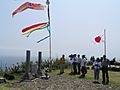
Reunion of Honor
On February 19, 1985, 40 years after the battle began, veterans from both the U.S. and Japan met on Iwo Jima for a "Reunion of Honor." They gathered near where the U.S. Marines had landed.
During the service, a granite plaque was revealed. It had a message in both English and Japanese:
On the 40th anniversary of the battle of Iwo Jima, American and Japanese veterans met again on these same sands, this time in peace and friendship. We commemorate our comrades, living and dead, who fought here with bravery and honor, and we pray together that our sacrifices on Iwo Jima will always be remembered and never be repeated.
Similar memorial services have been held every five or ten years since then. These events bring together veterans and their families to remember the sacrifices made during the battle.
Current Use of Iwo Jima
Iwo Jima is currently home to a Japan Maritime Self-Defense Force (JMSDF) naval air base. The airstrip is 2,650 meters (8,700 ft) long. The JMSDF handles air traffic control, fueling, and rescue operations. Sometimes, commercial airplanes flying across the Pacific use the airstrip for emergency landings.
The Japan Ground Self-Defense Force also has about 400 troops on the island. They are responsible for things like clearing unexploded bombs. The U.S. Navy also uses the base for training.
Regular people are not allowed to visit Iwo Jima. Only those attending memorial services, construction workers, and weather officials can go there. The Japanese troops stationed on the island register their addresses elsewhere, so officially, there is no permanent population on Iwo Jima.
Images for kids
-
60th Reunion 2005
-
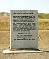
Reunion of Honor Memorial


See also
 In Spanish: Iōtō para niños
