
Kyushu-Palau Ridge facts for kids

The Kyushu-Palau Ridge (KPR) is a long, raised area on the bottom of the Philippine Sea. It's like an underwater mountain range or a very long hill. This ridge gets its name from two places nearby: Kyushu, a large island in Japan to the north, and Palau, an island nation to the south.
This underwater ridge starts about 900 kilometers (560 miles) from the Bungo Channel in Japan. It then stretches southeast all the way towards the island of Palau.
How the Ridge Was Formed
The Kyushu-Palau Ridge has a line of extinct volcanoes along it. These are volcanoes that are no longer active and won't erupt again. The ridge was created over millions of years by the movement of the Philippine Plate. The Earth's surface is made of huge pieces called plates, and when these plates move and push against each other, they can create mountains, volcanoes, and ridges like the KPR.
Related Underwater Features
Images for kids
-
This map shows the IBM arc system in the Western Pacific. The lines with arrows show where we can find information about the arc.
-
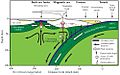
This picture shows a side view of a subduction zone. This is where one of Earth's plates slides under another. It also shows an active volcano area and a basin behind it.
-
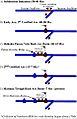
This picture shows how the IBM arc system has changed over time. Red areas were active with volcanoes, and blue areas are no longer active.
-
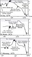
This picture shows the shape of the land and ocean floor along the IBM volcanic arc.
-
These pictures show the shape of the ocean floor across the IBM arc system. The "T" marks the trench, which is a very deep part of the ocean.
-
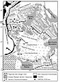
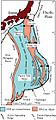
This map shows the geology and magnetic patterns of the western Pacific. The arrows show how the Pacific Plate moves compared to the Philippine Sea Plate. The numbers show how fast they move.
-
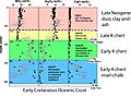
This picture shows sediment (like mud and sand) found at an ocean drilling site. It shows what the layers are made of and how old they are.
-
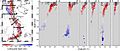
This map shows the depth and location of earthquakes in the IBM subduction zone. Lighter circles are shallower earthquakes, and darker circles are deeper ones. The lines on the right show cross-sections, helping us see how deep the earthquakes are.


See also
 In Spanish: Arco de Izu-Bonin-Mariana para niños
