Irupana facts for kids
Quick facts for kids
Irupana
|
|
|---|---|
|
Town
|
|

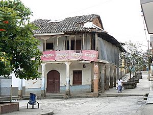
Main square in Irupana
|
|
| Country | |
| Department | La Paz Department |
| Province | Sud Yungas Province |
| Municipality | Irupana Municipality |
| Population
(2001)
|
|
| • Total | 1,882 |
| Time zone | UTC-4 (BOT) |
Irupana is a town located in the beautiful La Paz Department in Bolivia. It is found in the Sud Yungas Province, a region known for its green valleys and warm climate. Irupana is an important center for its local area. It serves as the main town for the Irupana Municipality.
Climate in Irupana
Irupana has a pleasant climate, typical of the Yungas region. It is located at an elevation of about 1,946 meters (6,385 feet) above sea level. This elevation helps keep temperatures mild.
The weather here is generally warm throughout the year. The average temperature stays around 17 to 20 degrees Celsius (63 to 68 degrees Fahrenheit). The hottest months are usually October and November. The coolest months are June and July, but it never gets very cold.
Irupana experiences a lot of rain, especially during the summer months from December to March. This rainfall makes the area very green and fertile. Even during the drier months, there is still some rain. The humidity is quite high all year round, often above 80%.
| Climate data for Irupana, elevation 1,946 m (6,385 ft) | |||||||||||||
|---|---|---|---|---|---|---|---|---|---|---|---|---|---|
| Month | Jan | Feb | Mar | Apr | May | Jun | Jul | Aug | Sep | Oct | Nov | Dec | Year |
| Record high °C (°F) | 33.0 (91.4) |
31.0 (87.8) |
30.5 (86.9) |
30.0 (86.0) |
31.5 (88.7) |
30.0 (86.0) |
28.7 (83.7) |
31.0 (87.8) |
32.0 (89.6) |
33.8 (92.8) |
33.0 (91.4) |
32.0 (89.6) |
33.8 (92.8) |
| Mean daily maximum °C (°F) | 24.9 (76.8) |
24.8 (76.6) |
25.1 (77.2) |
25.0 (77.0) |
24.3 (75.7) |
23.7 (74.7) |
23.6 (74.5) |
24.3 (75.7) |
24.8 (76.6) |
25.5 (77.9) |
26.0 (78.8) |
25.2 (77.4) |
24.8 (76.6) |
| Daily mean °C (°F) | 19.6 (67.3) |
19.5 (67.1) |
19.5 (67.1) |
19.4 (66.9) |
18.2 (64.8) |
17.2 (63.0) |
17.0 (62.6) |
17.7 (63.9) |
18.6 (65.5) |
19.5 (67.1) |
19.9 (67.8) |
19.6 (67.3) |
18.8 (65.9) |
| Mean daily minimum °C (°F) | 14.3 (57.7) |
14.1 (57.4) |
14.0 (57.2) |
13.7 (56.7) |
12.2 (54.0) |
10.8 (51.4) |
10.4 (50.7) |
11.3 (52.3) |
12.3 (54.1) |
13.4 (56.1) |
13.8 (56.8) |
14.1 (57.4) |
12.9 (55.2) |
| Record low °C (°F) | 5.5 (41.9) |
6.2 (43.2) |
8.5 (47.3) |
7.0 (44.6) |
1.5 (34.7) |
1.5 (34.7) |
5.0 (41.0) |
3.9 (39.0) |
6.0 (42.8) |
5.3 (41.5) |
5.2 (41.4) |
5.0 (41.0) |
1.5 (34.7) |
| Average precipitation mm (inches) | 190.2 (7.49) |
183.0 (7.20) |
137.6 (5.42) |
73.6 (2.90) |
42.8 (1.69) |
39.5 (1.56) |
37.2 (1.46) |
64.4 (2.54) |
95.8 (3.77) |
107.9 (4.25) |
109.4 (4.31) |
171.3 (6.74) |
1,252.7 (49.33) |
| Average precipitation days | 15.2 | 14.4 | 12.8 | 8.6 | 5.2 | 4.1 | 4.0 | 6.4 | 8.3 | 10.2 | 9.4 | 13.8 | 112.4 |
| Average relative humidity (%) | 82.8 | 84.5 | 83.9 | 83.0 | 82.8 | 83.7 | 81.7 | 82.2 | 82.2 | 82.1 | 81.9 | 81.3 | 82.7 |
| Source: Servicio Nacional de Meteorología e Hidrología de Bolivia | |||||||||||||
People of Irupana
According to the 2001 census, Irupana had a population of 1,882 people. The town serves as a hub for the surrounding rural communities. People in the area often work in agriculture, growing crops like coca, coffee, and fruits. The main square, shown in the image, is a central gathering place for residents.
Exploring the Yungas Region
Irupana is part of the Yungas region, which is famous for its unique geography. It is a transition zone between the high Andes mountains and the Amazon rainforest. This means you can find a mix of different plants and animals here. The area is very green and has many rivers and waterfalls. It is a beautiful place to visit and explore nature.
See also
 In Spanish: Irupana para niños
 | Laphonza Butler |
 | Daisy Bates |
 | Elizabeth Piper Ensley |


