Isla San Diego facts for kids

Isla San Diego is north of Isla San José
|
|
| Geography | |
|---|---|
| Location | Baja California Sur |
| Coordinates | 25°12′01″N 110°41′53″W / 25.20028°N 110.69806°W |
| Adjacent bodies of water | Gulf of California |
| Area | 0.563 km2 (0.217 sq mi) |
| Length | 1.5 km (0.93 mi) |
| Width | 500 m (1,600 ft) |
| Administration | |
| Demographics | |
| Population | Uninhabited |
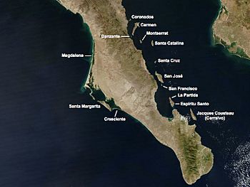
Isla San Diego is a small island in Mexico. It is located in the southern part of the Gulf of California. This island is part of the Comondú area in the state of Baja California Sur. It is very close to another small island called Isla La Habana.
Isla San Diego is a quiet, empty island. No one lives there. It is about 22 kilometers (14 miles) east of the coast of Baja California. It is also about 9.5 kilometers (6 miles) north of San Jose Island. And it's about 6 kilometers (4 miles) south-southeast of Santa Cruz Island.
About the Island
Isla San Diego is not very big. It is about 1.5 kilometers (0.9 miles) long. At its widest point, it is about 500 meters (547 yards) across. The total area of the island is about 0.563 square kilometers (0.217 square miles). This makes it a very small piece of land in the big Gulf of California.
The island is described as "barren." This means it does not have many plants or trees. It is likely a dry place, similar to a desert. Many islands in the Gulf of California are like this. They are often rocky and have little fresh water.
Location in the Gulf of California
The Gulf of California is a large body of water. It separates the Baja California Peninsula from the Mexican mainland. It is also known as the Sea of Cortés. This gulf is famous for its amazing sea life. Many different kinds of fish, whales, and other ocean animals live there. Even though Isla San Diego is uninhabited, it is part of this important natural area.
Want to Learn More?
- In Spanish: Isla San Diego para niños
 | Precious Adams |
 | Lauren Anderson |
 | Janet Collins |

