
Itagüí facts for kids
Quick facts for kids
Itagüí
|
|||
|---|---|---|---|
|
Municipality and city
|
|||
| Municipio de Itagüí | |||
 |
|||
|
|||

Location of the municipality and town of Itagüí in the Antioquia Department of Colombia
|
|||

Itagüí
Location in Colombia
|
|||
| Country | |||
| Department | |||
| Founded | 1743 | ||
| Area | |||
| • Municipality and city | 19.65 km2 (7.59 sq mi) | ||
| • Urban | 12.74 km2 (4.92 sq mi) | ||
| Elevation | 1,550 m (5,090 ft) | ||
| Population
(2020 est.)
|
|||
| • Municipality and city | 289,994 | ||
| • Density | 14,758/km2 (38,223/sq mi) | ||
| • Urban | 265,527 | ||
| • Urban density | 20,842/km2 (53,981/sq mi) | ||
| Demonym(s) | Itagüiseño | ||
| Time zone | UTC-5 (Colombia Standard Time) | ||
| Area code(s) | 57 + 4 | ||
| Website | Official website: http://www.itagui.gov.co/ | ||


Itagüí is a city and municipality in Colombia. It is located in the southern part of the Aburrá Valley in the Antioquia Department. Itagüí is also part of the larger Metropolitan Area of the Aburrá Valley.
Contents
Discover Itagüí: A Colombian City
Itagüí is a lively city in Colombia. It is known for its history and culture. The city is part of a bigger urban area. This area includes several other cities.
What is the Population of Itagüí?
In 2020, about 289,994 people lived in Itagüí. Back in 2005, the population was 230,272. The city covers an area of about 17.74 square kilometers.
The History of Itagüí: From Village to City
Itagüí was first settled in 1743. It became an official municipality in 1832. Some historians believe its name comes from an old indigenous chief named Bitagüí.
In the past, Itagüí had two chapels. One was built in 1743. This chapel later became a parish church. In 1774, a priest from Medellín wanted to create four parishes. Itagüí was one of them. In 1825, the people of Itagüí asked to become a parish district.
The first public primary school opened in 1832. In 1876, Itagüí got its first telegraph connection. This was a big step for communication!
Later, in 1931, the city built its first public water system. The Itagüí Library opened in 1945. It was built by a kind person named Diego Echavarría Misas. In 1962, the first official City Hall building started construction. The city's main administrative center, CAMI, opened in 1993. The Metropolitan Stadium of Itagüí also opened that year.
Where Did the Name Itagüí Come From?
The land where Itagüí is now was once home to the Nutabes tribe. These people were part of the Chibcha language family. They lived here from the early 1500s.
Some historians say the name "Itagüí" comes from an indigenous chief. His name was Bitagüí. His tribe might have lived in this area.
Geography and Landscape of Itagüí
Itagüí is in the southern part of the Aburrá Valley. This valley is located in the Andes mountains. The city is quite small, covering about 17 square kilometers. It is the third smallest municipality in Colombia. The entire city area is urbanized.
Itagüí has some small hills. These include High Manzanillo and the hills of Three Sweet Names. The main river is the Medellín River. This river forms the border with other nearby towns. The Doña María creek is an important stream in Itagüí.
Itagüí's Economy and Industries
Itagüí has a strong economy. It collects more taxes than some other areas. This has helped the city build new things. Itagüí is now one of Colombia's important economic centers.
In 1962, Colombia's first motorcycle factory opened here. It was called Auteco. Other big companies, like Carrefour, also have a presence in Itagüí.
A large distillery, FLA, has been making drinks for a century. They produce rums, liqueurs, and other spirits.
The city's government and economy are managed from the Municipal Administrative Center of Itagüí (CAMI). This building is like the city's town hall.
How Itagüí is Organized


Itagüí is divided into six main areas called communes. These communes have 64 districts. There is also a rural area called Manzanillo. It has 8 smaller paths or roads.
Itagüí shares a border with the city of Medellin to the north. Sometimes it's hard to tell where one city ends and the other begins!
The main communes are:
- Commune 1: Industrial Zone, San Juan Bautista, Centro, and more.
- Commune 2: Santa Catalina, Samaria, Santa Ana, and others.
- Commune 3: Las Brisas, Pilsen, San Gabriel, Ditaires, and more.
- Commune 4: Santa Maria, Colinas del Sur, San Fernando.
- Commune 5: Las Acacias, Calatrava, Terranova.
- Commune 6: Fátima, El Rosario, La Unión.
There are also rural areas called Sidewalks:
- La Verde
- Los Olivales
- El Pedregal
- Loma de los Zuleta
- El Progreso
- Los Gómez
- El Ajizal
- El Porvenir
The Metropolitan Area of the Aburrá Valley
The Metropolitan Area of the Aburrá Valley is a special administrative group. It covers the entire Aburrá Valley. The average height of this area is about 1,538 meters above sea level.
This area includes 10 different municipalities. The Medellín River flows through it from south to north. This river starts in Caldas and changes its name to Rio Porce in Barbosa.
This was the first metropolitan area created in Colombia in 1980. It is the second largest in population after Bogotá. More than 3.3 million people live in this metropolitan area.
The main cities in this area are Medellín, Bello, Itagüí, and Envigado.
Culture and Arts in Itagüí
Itagüí is known for its industries and businesses. But it is also an important cultural center. Many talented artists come from Itagüí. These include painter Eladio Vélez, poet Carlos Enrique Sierra, and sculptor Salvador Arango.
The Eladio Vélez Art School helps citizens learn about art. The city's main cultural building is the House of Culture of Itagüí Diego Echavarría Misas. There is also the Museum Graciliano Arcila Vélez. This museum has old items from the tribes that lived here long ago. Itagüí also has the South Auditorium for events.
Famous People from Itagüí
- Salvador Arango (born 1944) - A famous sculptor.
- Camilo Monroy (born 1998) - A notable person from the city.
Festivals and Events in Itagüí
Itagüí hosts many fun events throughout the year:
- The Festival of Industry, Trade and Culture lasts for eight days. It ends with the unique World Day of Laziness. Both of these events started in Itagüí!
- Theatre Festival City Itagüí - A festival for plays and performances.
- Poetry Festival Park - An event celebrating poetry.
- October event, Our Lady of the Rosary - A religious celebration.
- Party of New Year - Celebrations for the new year.
Getting Around Itagüí: Transportation
The city has four metro stations: Itagüí, Envigado, Sabaneta, and La Estrella. These stations connect Itagüí directly to Medellín and other towns. There is also a large bus system. It takes people to and from the metro stations. Taxis are also available for getting around the city.
Sports in Itagüí
Itagüí has a history with professional football (soccer) teams. From 2008 to 2014, a team called Itagüí F.C. played in Colombia's top division. This team later moved to Rionegro.
However, Itagüí got a new team in 2016 called Leones. They played in the top division in 2018. As of 2023, they play in the second division. The team plays its games at the Estadio Metropolitano Ciudad de Itagüí.
Images for kids
-
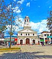
Church in central park of Itagüí
-
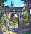
Itagüí cemetery


See also
 In Spanish: Itagüí para niños
