
Jánico facts for kids
Quick facts for kids
Jánico
Municipio de Janico
|
||
|---|---|---|
|
Town and municipality
|
||

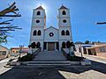
Janico, Dominican Republic town church.
|
||
|
||

Jánico
Location in the Dominican Republic
|
||
| Country | ||
| Province | Santiago | |
| Settled | 16 March 1494 | |
| Incorporated | 29 March 1881 | |
| Area | ||
| • Total | 235.03 km2 (90.75 sq mi) | |
| Elevation | 370 m (1,210 ft) | |
| Population
(2010)
|
||
| • Total | 16,993 | |
| • Density | 72.301/km2 (187.260/sq mi) | |
| • Urban | 1,730 | |
| • Rural | 15,263 | |
| Municipal Districts | 2 |
|

Jánico (pronounced HAH-nee-koh) is a small mountain town and municipality in the Santiago province of the Dominican Republic. It's located in the Central Mountain Range.
Jánico is found east of San Jose de las Matas, west of Sabana Iglesia, and southwest of Santiago de los Caballeros. The municipality includes two municipal districts: Juncalito and El Caimito. Jánico became a municipality on March 29, 1881.
Because it's in the Central Mountain Range, Jánico is quite high up, about 370 meters (1,214 feet) above sea level. This gives the area a very pleasant climate.
Contents
What's in a Name?
The name Jánico comes from the Santo Tomas de Janico fortress. This fortress was built in 1494 by Spanish settlers. The name Jánico itself comes from the Janicus River.
A Look Back in Time
Jánico was first settled in March 1494. This happened when the famous explorer Christopher Columbus set up a small fort there. He wanted to protect his gold mining plans in the area. Gold had been found earlier that year by an expedition led by Alonso de Ojeda.
In 1494, Columbus also ordered the building of the Santo Tomás de Jánico Fortress. This was the first fortress built inland on the island. It was also the second fortress ever built in all of America. Some parts of this old fortress can still be found in Jánico today.
Because of its location in the Central Mountain Range, Jánico became a safe place for many people. White and mixed-race refugees came here from other areas. Some came during slave revolts in 1805.
Jánico officially became a municipality on March 29, 1881. This was 387 years after it was first settled.
Where is Jánico?
Jánico is part of a region known as the Sierra. This area was settled in the 1700s by people from different backgrounds. Many came from the Canary Islands and France. They formed a close-knit community.
Who Lives in Jánico?
The people of Jánico have a rich and diverse heritage. Studies have shown that the town has a mix of European, pre-Columbian (native islander), and African roots. This blend of cultures makes Jánico a unique place.
How People Make a Living
The main way people in Jánico earn money is through farming. Coffee growing is very important here. Jánico is one of the biggest coffee-producing areas in the Dominican Republic.
Money sent home by family members living abroad, called remittances, also helps the local economy a lot.
Fun Things to See
Jánico's location in the mountains means it has beautiful landscapes. This makes it a great spot for mountain tourism.
Some cool places to visit include:
- The Bao reservoir, a large lake.
- A botanical garden with 700 hectares (about 1,730 acres) of land.
On its border with the municipality of Sabana Iglesia, you'll find the Taveras hydroelectric complex. This complex uses the Yaque del Norte and Bao rivers to create electricity. It includes the Taveras and Bao dams, and the López Angostura reservoir. This system provides a lot of electricity for the country. It also helps water about 9,100 hectares (about 22,500 acres) of farmland.
Images for kids
-
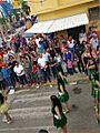
People of Janico, Dominican Republic.
-
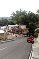
Streets in Jánico, Dominican Republic.
-
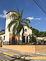
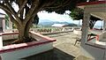
A view of Jánico town.
-
Countryside near Jánico.
-
A view of Juncalito, a district in Jánico.
-
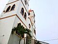
The church in Jánico.


See also
 In Spanish: Jánico para niños
