Jiguaní facts for kids
Quick facts for kids
Jiguaní
|
|
|---|---|
 |
|

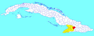
Jiguaní municipality (red) within
Granma Province (yellow) and Cuba |
|
| Country | Cuba |
| Province | Granma |
| Established | 1701 |
| Area | |
| • Total | 646 km2 (249 sq mi) |
| Elevation | 125 m (410 ft) |
| Population
(2022)
|
|
| • Total | 58,982 |
| • Density | 91.30/km2 (236.47/sq mi) |
| Time zone | UTC-5 (EST) |
| Area code(s) | +53-23 |
| Website | https://www.jiguani.gob.cu/es/ |
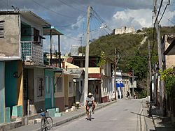
Jiguaní (pronounced hee-gwah-NEE) is a town and a special area called a municipality in Granma Province, Cuba. It is located about 25 kilometers (15 miles) east of Bayamo, which is the main city of the province.
Contents
About Jiguaní: Location and Name
Jiguaní is a municipality, which is like a county or district. It includes the main town and several smaller areas called barrios. These barrios are Babiney, Baire, Bijagual, La Villa, Los Negros, Maffo, Rihito, and Santa Rita.
The name "Jiguaní" comes from the Taíno people, who were the original inhabitants of Cuba. In their language, it means "height of the river". This name likely describes the area's geography.
Jiguaní's History: A Key Location
Jiguaní has an important place in Cuban history. It was established in 1701. The town was a strong base during the Cuban War of Independence in 1895. This war was a major fight for Cuba to become free from Spanish rule. Jiguaní served as a starting point for many important events during this time.
People and Area: Jiguaní's Population
In 2022, about 58,982 people lived in the municipality of Jiguaní. The total area of Jiguaní is about 646 square kilometers (249 square miles). This means that for every square kilometer, there are about 91 people. This number tells us how crowded or spread out the population is.
See also
 In Spanish: Jiguaní para niños
 | Madam C. J. Walker |
 | Janet Emerson Bashen |
 | Annie Turnbo Malone |
 | Maggie L. Walker |

