Joe Bell site facts for kids
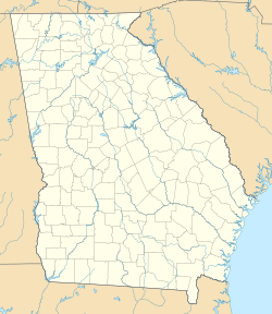
| Location | Morgan County, Georgia, |
|---|---|
| Region | Morgan County, Georgia |
| Coordinates | 33°32′28.9″N 83°16′40.8″W / 33.541361°N 83.278000°W |
| Site notes | |
| Excavation dates | 1969 |
The Joe Bell site (also known as 9MG28) is an archaeological site in Morgan County, Georgia. Today, it lies hidden beneath the waters of Lake Oconee. Before the 1970s, it was located near where the Apalachee River meets the Oconee River. From the site, you could see where these two rivers joined.
Contents
Discovering the Joe Bell Site
The Joe Bell site was first visited in 1968 by Marshall Williams. He went there because the landowner, Joe Bell, suggested it. Mr. Bell had found many old objects while plowing his land.
Early Surveys and Digs
Marshall Williams and Mark Williams found this site during their surveys. They were looking for old places because of a new highway being built. Mark Williams later studied the site for his PhD.
In 1969, archaeologists started digging at the site. They focused on four main areas. They found many small pieces of pottery. These pieces showed that people lived there during different time periods.
Uncovering Hidden Features
During the 1969 digs, a road grading machine helped remove the top layer of soil. This uncovered two important areas called Features 1 and 2. These areas were then carefully dug up and studied.
Major Excavations in 1977
In 1977, Marshall Williams and Mark Williams returned to the Joe Bell site. There were plans that might damage the site. So, a big excavation (dig) took place from June to September 1977.
Focusing on the Bell Phase Area
Most of the work in 1977 focused on Area 2. This part of the site is known as the Bell Phase area. It was probably about 1.5 acres in size.
Archaeologists found many interesting things. They found 55 special spots called "features." However, because of time, they could only dig up 17 of them. They also found over 1100 post holes, which are marks left by old wooden posts.
Mapping the Site
The next year, volunteers helped map about 80% of the area. This was the part that the heavy machinery had cleared. Mapping helps archaeologists understand how the ancient village was laid out.
What Did Archaeologists Find?
The digs at the Joe Bell site revealed a lot about the people who lived there long ago. They found different kinds of structures and areas where people threw away their trash.
Trash Pits and Pottery
Some of the features were like ancient trash pits. These were circular holes filled with old food scraps and broken pottery. Archaeologists found many pottery pieces in these pits. Some of these pieces could even be put back together to form whole pots!
Important Buildings
Archaeologists found evidence of a large circular building. This building was likely a rotunda. It was probably the main place for social gatherings, political meetings, and religious ceremonies for the people living there.
Homes and Shelters
Many of the features were small, circular structures. These were partly dug into the ground. They were probably used as sleeping places on cold nights. They also found evidence of structures used during warmer weather.
One large trash pit was especially interesting. It seemed to have been filled up all at once. The contents were burned either during or after they were put in the pit. This pit contained many pottery pieces, including some that could be rebuilt. Experts believe this pit might have been created during a special ceremony. This ceremony is called the Busk or Green Corn ceremony. It was a time for the community to clean and renew itself.
 | Bayard Rustin |
 | Jeannette Carter |
 | Jeremiah A. Brown |


