Johnson's Harbour facts for kids
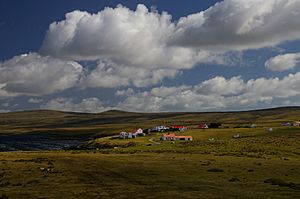
Johnson's Harbour is a small settlement located on the northeast coast of East Falkland in the Falkland Islands. It sits right on the shore of Berkeley Sound, at the very end of a small stream called Chabot Creek. The bay it's located on is also known as Johnson's Harbour. This quiet place has a small store, but the FIGAS (Falkland Islands Government Air Service) planes only land there if there's an emergency. Around Johnson's Harbour, you can find hills like North Lookout, Diamond Mountain, and Hawk Hill.
History of Johnson's Harbour
Johnson's Harbour has a history that goes back many years. In November 1836, a naval officer named Admiral George Grey was exploring and mapping the area. He wrote down his thoughts about what he saw when his ship anchored near Johnson's Harbour.
He described the islands as looking quite gloomy at first, especially because the day was cloudy and rainy. The shores of Berkeley Sound were steep, with bare hills and valleys. There were no trees, and the low clouds made the place look like the Cheviot Hills or a Scottish moor on a winter day. Even though it was "May" in the Southern Hemisphere (which is like spring), the weather didn't seem very good at first. However, Admiral Grey noted that the temperature was actually quite warm, around 63 degrees Fahrenheit (about 17 degrees Celsius), which he compared to a mid-summer day in Howick, England.
This early description helps us understand what the Falkland Islands looked like to explorers nearly 200 years ago.
See also
 In Spanish: Puerto Johnson para niños
 | Selma Burke |
 | Pauline Powell Burns |
 | Frederick J. Brown |
 | Robert Blackburn |


