Kancab facts for kids
Quick facts for kids
Kancab
|
|
|---|---|
|
Town
|
|
| Country | |
| State | Yucatán |
| Municipality | Tekax |
| Elevation | 90 m (300 ft) |
| Population
(2010)
|
|
| • Total | 2,819 |
| Time zone | UTC-6 (Central Standard Time) |
| • Summer (DST) | UTC-5 (Central Daylight Time) |
| Postal code (of seat) |
97970
|
| Area code(s) | 997 |
| INEGI code | 310790010 |
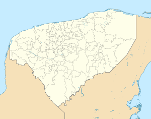
Kancab is a small town located in the Tekax Municipality in Yucatán, Mexico. In 2010, about 2,819 people lived there. The town is part of the larger state of Yucatán. It is known for its quiet community life.
Contents
Population Growth in Kancab
The number of people living in Kancab has changed a lot over the years. Looking at the population numbers helps us understand how the town has grown.
Historical Population Figures
Here is a look at how Kancab's population has changed over time:
| 1910 | 1921 | 1930 | 1940 | 1950 | 1960 | 1970 | 1980 | 1990 | 1995 | 2000 | 2005 | 2010 |
|---|---|---|---|---|---|---|---|---|---|---|---|---|
| 435 | 193 | 300 | 420 | 551 | 756 | 1044 | 1031 | 1706 | 2113 | 2419 | 2670 | 2819 |
As you can see, Kancab has grown quite a bit since 1910. Back then, fewer than 500 people lived there. By 2010, the population was much larger, showing steady growth over many decades.
Local Government
Kancab is part of the Tekax Municipality. The mayor of the municipality helps lead the area. The current mayor is Joshua Manance Couoh Tzec. Mayors work to make sure the town has good services. These services include things like roads and public safety.
Geography and Location
Kancab is located in the state of Yucatán, Mexico. It sits at an elevation of about 90 meters (295 feet) above sea level. The town's exact coordinates are 20 degrees, 11 minutes, 40 seconds North and 89 degrees, 20 minutes, 44 seconds West. This location places it in the Central Standard Time zone.
See also
 In Spanish: Kancab para niños
 | Anna J. Cooper |
 | Mary McLeod Bethune |
 | Lillie Mae Bradford |


