Karewa / Gannet Island facts for kids
|
Māori: Karewa
|
|
|---|---|

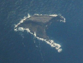
Aerial view of Gannet Island
|
|
|
Location of Gannet Island
|
|
| Geography | |
| Location | Waikato region |
| Coordinates | 37°58′19″S 174°33′58″E / 37.97194°S 174.56611°E |
| Highest elevation | 15 m (49 ft) |
| Administration | |
|
New Zealand
|
|
| Demographics | |
| Population | 0 |
Gannet Island, also known as Karewa in Māori, is a small island off the west coast of New Zealand's North Island. It is located about 19 kilometers (12 miles) from the town of Kawhia. This island is a special place because it is home to many seabirds, especially gannets.
What is Gannet Island Like?
Gannet Island was formed a very long time ago, about half a million years ago. It is what's left of an ancient volcano's "tuff ring." A tuff ring is a low, flat volcano made from ash and rock fragments that exploded out of the ground. The island rises about 15 meters (49 feet) above the sea. Its base goes down about 65 meters (213 feet) into the ocean.
Because the island is quite low, big ocean waves can sometimes wash right over it. This means there isn't much space for plants to grow. Only about 3 square meters (32 square feet) of the island has any plant life. You can find tough plants like Prasiola (a type of algae), Tortula (moss), and different kinds of lichens such as Xanthoria and Xanthoparmelia. These plants are very good at surviving in harsh, salty conditions.
Gannets: The Island's Main Residents
Gannet Island is a protected wildlife sanctuary. This means it's a safe place for animals, especially birds, to live and raise their young without being disturbed. The island is famous for being the largest single breeding colony of Australasian gannets in New Zealand.
In 1980, a count showed that about 8,000 pairs of gannets were nesting and raising their chicks on the island. Because so many important birds live here, BirdLife International has named Gannet Island an "Important Bird Area." This title helps make sure the island and its amazing bird population stay protected for future generations.
 | William Lucy |
 | Charles Hayes |
 | Cleveland Robinson |


