
Kilmaurs Castle facts for kids
Quick facts for kids Kilmaurs Castle |
|
|---|---|
| Kilmaurs, East Ayrshire, Scotland UK |
|

Field clearance stones at the site of Kilmaurs Castle
|
|

Kilmaurs Castle
|
|
| Coordinates | 55°38′08″N 4°30′41″W / 55.635480°N 4.511272°W |
| Type | A tower castle |
| Site information | |
| Owner | Jocksthorn Farm |
| Open to the public |
Yes |
| Condition | Demolished and 'robbed' |
| Site history | |
| Built by | The De Morville or Cunninghame family |
| Materials | Stone |
Kilmaurs Castle was a historic building located on Jocksthorn Farm near Kilmaurs in East Ayrshire, Scotland. In the early 1600s, a writer named Timothy Pont described it as an "ancient strong building" belonging to the Earls of Glencairn. He said it was surrounded by a nice park called Carmell Wood, with the Carmell Water flowing nearby.
Another historian, Dobie, suggested that this old castle was about a mile south-east of Kilmaurs. He noted that some ruins could still be seen on Jock's-thorn farm. This spot might have been the very first property owned by the Cunninghame family. It's important not to confuse Kilmaurs Castle with Kilmaurs Place, which was a newer building also owned by the Cunninghame family.
Castle History

Kilmaurs Castle was likely first owned by the De Morville family. Later, in 1527, Cuthbert Cunninghame is thought to have lived there. It's believed that the castle quickly fell into disuse and decay after the newer Kilmaurs Place was built.
A map from around 1600 by Timothy Pont shows a typical tower castle within an enclosed area. It also shows a second enclosed woodland area next to the Carmell Water. The map marks a mill and a dwelling called 'Karmel-Wood', a farm that still exists today. The site is named 'Kilmaers' and is located south of the church. This map only shows one tower in the area, and Jocksthorn is not marked. Kilmaurs Castle is the only site shown with a second wooded enclosure.
In 1612, John Monipennie stated that Kilmaurs Castle was where the Earls of Glencairn lived. This suggests that Kilmaurs Place was not yet built, or at least not ready to be their main home.
Moll's map from the early 1700s also shows the castle, but without the enclosures. Jocksthorn and Kilmaurs Place are not shown on this map.
The Statistical Account from 1791-99 mentions that the Earl of Glencairn once lived in this area. It says that "some small ruins" of their house still remained on the farm called Jock's-thorn. This farm was near the road between Stewarton and Kilmarnock.
Roys' military map from the 1750s shows a large area of probable woodland where Kilmaurs Castle was believed to have stood. Armstrong's map from 1775 indicates a castle-like building at the supposed site, which seems connected to the name 'Jock's Thorn'.
In 1875, Adamson wrote that the old castle was near Jock's or Jack's Thorn farm, now called 'Jocksthorn'. Several older people from Kilmaurs in 1875 remembered playing among the ruined stone pieces of this old Cunninghame castle.

Adamson also described the old trees and avenues that were typical of such a grand home, which were still there in the 1870s. These features are not usually found on farms. He further supported the castle's location by describing a "sward covered circular mound" or motte at the traditional site.
In 1884-86, the Ordnance Gazetteer of Scotland noted that Jock's Thorn farm contained "vestiges" (traces) of the original home of the Glencairn family. The RCAHMS (Royal Commission on the Ancient and Historical Monuments of Scotland) records also show map evidence of a castle-like building at this spot, likely a typical Scottish tower castle.
The lack of stone at the site today, despite clear records of ruins, suggests that much of the stone was taken away. This stone was probably used to build other projects, like Jocksthorn Farm or Kilmaurs Place. The old castle was on a lane, which made it easy to transport building materials to other locations.
Clues About the Site
The word 'Thorn' in Jocksthorn might come from an old word meaning 'tower'. For example, Jocks-Thorn on Cumbrae was also known as Jock-Torn. 'Thorn' can also mean 'assembly', 'meeting place', or a 'clearing' in the land.
The traditional site of the castle has many field clearance stones. These are stones that farmers have removed from the fields and piled up along the hedge leading to Jocksthorn Farm.
Even though the site isn't in a strong defensive position, it offers amazing views of the surrounding area. You can see these views in the gallery below.
- Views from the Site of Kilmaurs Castle
-
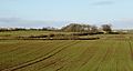
Bellsland Farm and the view to the north-east.
-
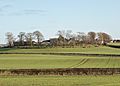
Grassmillside Farm and the view to the south-east.
-
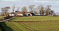
Jocksthorn Farm and the view to the north-west.
-
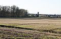
St Maurs-Glencairn church, Tour and the view south-west.


The RCAHMS Canmore site notes that "slight undulations" (small bumps) in the ground suggest past activity. Many large, shapeless stones are piled against a nearby hedge. The farmer at Jocksthorn says that this area is difficult and stony to plough.
Davis mentions that the local farmer has found pottery and stones when ploughing at a raised spot (NS 417 411). This spot is off the old entrance to Jocksthorn farm, east of both Tour House and Jock's Thorn.
People using metal detectors have found several medieval coins in this area. They were found among what might be old building and foundation stones. The 19th-century 6-inch OS Map of Kilmaurs marks the supposed site of Kilmaurs Castle. It lies off the side of the farm road leading to Jocksthorn Farm from the old Stewarton Road.

Dobie wrote in 1874 that the old baronial home was about a mile south-east of Kilmaurs. He noted that ruins could still be seen on the farmlands of Jocksthorn.
| Word Meanings |
| The name Carmel, which was originally Caremuall, is thought to come from Gaelic words. According to McNaught, 'Car' means 'fort', and 'Meall' means 'hill'. So, Carmel likely means 'The fort on the hill'. |
Interesting Facts
Dobie recorded that the castle stood within a park known as 'Carmell Wood', named after the Carmell Water. A farm called Carmellwood is located to the north-east of where the castle once stood.
The Tour Burn flows underground in a pipe from the Stewarton road near Grassmillside. It goes to near the corner of the field next to the Tour woodland. It's not known if this underground pipe is related to the castle or its old grounds.
The site of Kilmaurs Castle is almost two miles from Kilmarnock and four miles from Stewarton.
