
Kyle Castle facts for kids
Quick facts for kids Kyle Castle |
|
|---|---|
| Dalblair, Muirkirk, East Ayrshire, Scotland UK |
|

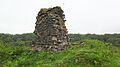
Remnants of the castle's keep from the courtyard area
|
|

Kyle Castle
|
|
| Coordinates | 55°26′53″N 4°08′24″W / 55.447921°N 4.1400316°W |
| Type | A tower castle with a courtyard |
| Site information | |
| Owner | Marquis of Bute |
| Open to the public |
Yes |
| Condition | Ruined and extensively robbed |
| Site history | |
| Built | 15th century |
| Built by | Farquhar of Gilmilnscroft |
| In use | 15th to early 18th century |
| Materials | Stone |

Kyle Castle is an old, ruined castle in East Ayrshire, Scotland. It's also been called Cavil Castle or Dalblair Castle. You can find its remains near the small village of Dalblair, close to Muirkirk.
The castle sits in a strong spot where two rivers, the Guelt Water and the Glenmuirshaw Water, meet. They form a small peninsula, making it a naturally protected place. The castle's name suggests it was once a very important building.
Long ago, there was a drawing of Kyle Castle when it was still standing. This drawing was kept at a church in Coylton. It showed a tall, four-story building with four rooms. These rooms were all connected by a staircase.
The castle is also special because it sits right on the old border between two historic areas: Kyle Regis and Kyle Stewart. This border was marked by the two rivers joining together. Not far away, there's an old fort called Dornal Motte, which was shown on a map from the 1500s.
Contents
History of Kyle Castle
Who Owned Kyle Castle?
The first time Kyle Castle was written about was in 1445. Before that, the land and castle belonged to the monks of Melrose Abbey. Then, a family called the Farquhars of Gilmilnscroft took over. John Farquhar was given the land by a leader from Melrose Abbey.
The Farquhars got more land over time, including Gilmilnscroft itself. John Farquhar's wife was Margaret, whose father was the Laird of Barquharrie. Later, the Cunninghame family owned the castle. After them, it passed to the Stewarts of Bute.
Why is Kyle Castle a Ruin?
Not much is known about Kyle Castle's daily life. People have sometimes linked it to an old legend about 'Old King Cole'. Sadly, many of the castle's stones were taken away. They were used to build stone walls and houses in the nearby Dalblair and Kyle Farms.
It seems the castle was left to fall apart by the late 1700s. Maps from that time show it was already in ruins. Perhaps a small part of the castle was left standing on purpose. It might have been a useful landmark in the empty landscape.
What Kyle Castle Looks Like Now

Kyle Castle was built in a very strong place. It has super steep slopes on three sides, making it hard for enemies to attack. Experts think it was built between the 1400s and 1500s.
The main part of the castle was a strong, rectangular tower. Today, it measures about 14 meters long and 7 meters wide. One wall, made of finely cut stone, is still standing. It's about 6 meters long, 5.5 meters high, and 1.8 meters thick.
The castle sat on a flat-topped hill. It probably had a courtyard wall around it, called a barmkin. You can still see raised parts along the edge of this area. There might have even been a watchtower at the far western end.
To the west, a deep, narrow path winds up to the courtyard and the main tower. This path was likely covered for protection. There's also a dry ditch, like a moat, on the north-east side of the ruins.
Old Maps of Kyle Castle

A map from the 1500s by Timothy Pont shows "Castle Keyil" on its hill. It looked like it had three towers and a wall around it. Even though these drawings were simple, Kyle Castle was shown as bigger than other castles nearby. It was also clearly named as a "castle."
Another map from 1685 by Adair also shows Castle Kyle. By 1745, Moll's map showed it as just one tower. Roy's map from the mid-1700s still showed the Castle of Kyle. It also showed some buildings that might be Kyle Farm, suggesting stones were already being taken from the castle.
By 1775, Armstrong's map clearly marked the castle as a ruin. And in 1832, Thomson's map also recorded it as being in ruins.
As mentioned, many stones from the castle were used for other buildings. It was hard to pull the stones apart because the mortar holding them was very strong. The parts of the castle that remain today are still a useful landmark in this quiet area. An old picture from 1863 shows that the ruins haven't changed much in a long time.
Images for kids
-
Remnants of the castle's keep from the courtyard area
-
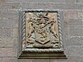
Coat of arms of the Farquhars of Gilmilnscroft
-
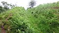
The covered walkway
-
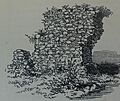
The castle ruins in 1863.
