
La Petite Décharge facts for kids
Quick facts for kids La Petite Décharge |
|
|---|---|
 |
|
| Country | Canada |
| Province | Quebec |
| Region | Saguenay-Lac-Saint-Jean |
| Regional County Municipality | Le Fjord-du-Saguenay Regional County Municipality |
| City | Alma |
| Physical characteristics | |
| Main source | Lac Saint-Jean Alma 101 units? 48°33′54″N 71°45′34″E / 48.565113°N 71.759434°E |
| River mouth | Saguenay River Alma 68 m (223 ft) 48°32′20″N 71°36′59″E / 48.538936°N 71.616268°E |
| Length | 16.2 km (10.1 mi) |
| Basin features | |
| Tributaries |
|
La Petite Décharge is a river in Quebec, Canada. It's one of two rivers that flow out of Lac Saint-Jean. The other one is called La Grande Décharge.
This river flows south of Alma Island, near the city of Alma. It's located in the Saguenay-Lac-Saint-Jean region of Quebec. La Petite Décharge forms the southern edge of Alma Island. East of this island, both rivers meet to form the Saguenay River.
The area around the river is used for city life, industries, and fun activities like tourism. You can reach La Petite Décharge from different roads and streets.
The river usually freezes from late November to early April. It's generally safe to walk on the ice from mid-December to late March.
Contents
River's Path and Surroundings
La Petite Décharge is about 16.2 kilometers (10 miles) long. It has many rapids along its way, which are parts where the water flows very fast over rocks.
The main areas next to La Petite Décharge are:
- North: La Grande Décharge, Rivière aux Chicots, Rivière aux Harts, Mistouk River
- East: Saguenay River
- South: Bédard River
- West: Lac Saint-Jean
La Petite Décharge starts from Lac Saint-Jean in Alma. Its mouth, where it flows into another river, is about 11 kilometers (6.8 miles) west of downtown Alma.
How the River Flows
The river flows for 16.2 kilometers (10 miles) through forests and then through the city. Here's how it moves:
- It flows about 3.2 kilometers (2 miles) east, then north. The river gets wider here.
- Then, it flows 3.2 kilometers (2 miles) southeast. This is where the Bédard River joins it.
- Next, it goes 7.6 kilometers (4.7 miles) east through Alma. It passes under several bridges, including a railway bridge.
- Finally, it flows 2.2 kilometers (1.4 miles) east through the Alma Hydrobase area to its mouth.
La Petite Décharge meets La Grande Décharge at the eastern tip of Alma Island. This is where they both join the Saguenay River. This meeting point is about 2.1 kilometers (1.3 miles) east of downtown Alma.
River's Name History
The name "La Petite Décharge" was first mentioned by a surveyor named Edmond Duberger in 1861. It probably got its name sometime in the 1700s.
The name was officially recognized on December 5, 1968, by the Commission de toponymie du Québec.
Images for kids
-
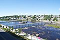
Passerelle du centenaire
-
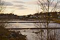
Les paliers de la Petite Décharge
-
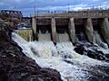
Barrage sur la rivière la Petite-Décharge


Related Articles
- Alma, a city
- Lac-Saint-Jean-Est Regional County Municipality
- Saguenay River, a stream
- La Grande Décharge, a stream
- Lac Saint-Jean, a body of water
- Alma Island
- Maligne Island hydroelectric plant
- List of rivers of Quebec
