La Virginia facts for kids
Quick facts for kids
La Virginia
|
|||
|---|---|---|---|
|
Municipality and town
|
|||

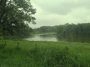
Cauca River. Between Cartago and La Virginia, Risaralda, Colombia.
|
|||
|
|||

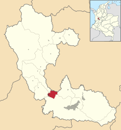
Location of the municipality and town of La Virginia in the Risaralda Department of Colombia.
|
|||
| Country | |||
| Department | Risaralda Department | ||
| Elevation | 899 m (2,949 ft) | ||
| Population
(2023)
|
|||
| • Total | 28,488 | ||
| Time zone | UTC-5 (Colombia Standard Time) | ||
La Virginia is a town and a type of local government area called a municipality in Colombia. It is located in the Risaralda Department. This town is about 50 kilometers (about 31 miles) away from Pereira, which is the capital city of Risaralda. In 2023, about 28,488 people lived in La Virginia.
History of La Virginia
La Virginia was founded in 1959 by a group of people including Francisco Jaramillo, Pedro Martínez, and Leonardo Villa.
In its very early days, this area was a special place called a Palenque. A Palenque was a safe community built by people who had escaped from slavery. The first small settlement here was named Sopinga. Later, in the mid-1800s, it was called Nigricia.
On November 27, 1959, La Virginia officially became a municipality. Before this, it was part of another area called Belalcazar, in the Caldas Department.
Climate
La Virginia has a warm climate all year round. The average temperature is about 23°C (73°F). This means it's usually quite pleasant, not too hot or too cold.
The area also gets a lot of rain throughout the year. This helps the plants and nature around La Virginia to grow well.
| Climate data for La Virginia (Bomehia La), elevation 970 m (3,180 ft), (1981–2010) | |||||||||||||
|---|---|---|---|---|---|---|---|---|---|---|---|---|---|
| Month | Jan | Feb | Mar | Apr | May | Jun | Jul | Aug | Sep | Oct | Nov | Dec | Year |
| Mean daily maximum °C (°F) | 30.6 (87.1) |
31.0 (87.8) |
30.6 (87.1) |
29.9 (85.8) |
29.6 (85.3) |
29.7 (85.5) |
30.3 (86.5) |
30.7 (87.3) |
30.5 (86.9) |
29.5 (85.1) |
29.2 (84.6) |
29.6 (85.3) |
30.1 (86.2) |
| Daily mean °C (°F) | 24.1 (75.4) |
24.3 (75.7) |
24.2 (75.6) |
23.9 (75.0) |
23.8 (74.8) |
23.9 (75.0) |
24.1 (75.4) |
24.4 (75.9) |
23.9 (75.0) |
23.4 (74.1) |
23.4 (74.1) |
23.7 (74.7) |
23.9 (75.0) |
| Mean daily minimum °C (°F) | 19.1 (66.4) |
19.3 (66.7) |
19.3 (66.7) |
19.5 (67.1) |
19.5 (67.1) |
19.1 (66.4) |
18.8 (65.8) |
18.7 (65.7) |
18.8 (65.8) |
18.9 (66.0) |
19.1 (66.4) |
19.1 (66.4) |
19.1 (66.4) |
| Average precipitation mm (inches) | 109.3 (4.30) |
105.7 (4.16) |
176.0 (6.93) |
210.5 (8.29) |
247.2 (9.73) |
148.4 (5.84) |
131.0 (5.16) |
122.2 (4.81) |
161.3 (6.35) |
184.6 (7.27) |
216.7 (8.53) |
139.4 (5.49) |
1,952.3 (76.86) |
| Average precipitation days | 13 | 13 | 17 | 20 | 20 | 17 | 14 | 13 | 16 | 20 | 20 | 16 | 197 |
| Average relative humidity (%) | 74 | 73 | 75 | 78 | 80 | 78 | 74 | 72 | 74 | 77 | 78 | 77 | 76 |
| Mean monthly sunshine hours | 198.4 | 166.6 | 170.5 | 141.0 | 148.8 | 150.0 | 182.9 | 186.0 | 162.0 | 151.9 | 156.0 | 179.8 | 1,993.9 |
| Mean daily sunshine hours | 6.4 | 5.9 | 5.5 | 4.7 | 4.8 | 5.0 | 5.9 | 6.0 | 5.4 | 4.9 | 5.2 | 5.8 | 5.5 |
| Source: Instituto de Hidrologia Meteorologia y Estudios Ambientales | |||||||||||||
See also
 In Spanish: La Virginia para niños
 | Calvin Brent |
 | Walter T. Bailey |
 | Martha Cassell Thompson |
 | Alberta Jeannette Cassell |


