Lake Leopoldo facts for kids
Quick facts for kids Lake Leopoldo |
|
|---|---|
| Lake Leopold | |

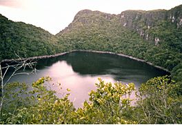
Lago Leopoldo / Autana. Photo taken in April 1973. The level of the water has decreased substantially in recent years such that the edges now consist of sandy beaches.
|
|
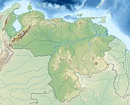
| Location | Venezuela |
| Coordinates | 4°57′57″N 67°29′08″W / 4.9657°N 67.4855°W |
| Type | lake |
| Max. length | 320 metres (1,050 ft) |
| Max. width | 240 metres (790 ft) |
| Max. depth | 20 metres (66 ft) |
| Surface elevation | 384 metres (1,260 ft) |
Lago Leopoldo, also known as Lake Leopold, is a special lake found in the Venezuelan Amazon. It's located in the western part of the Guiana Shield, a very old landform. The lake is about 320 meters (1,050 feet) long and 240 meters (790 feet) wide. It can be as deep as 20 meters (66 feet).
The lake sits high up, about 384 meters (1,260 feet) above sea level. Its water level might have dropped in recent years. The lake is named after King Leopold III of Belgium. He led an expedition in 1952, exploring rivers near the lake. However, it's not certain if his team ever reached the lake itself.
Lago Leopoldo was first seen from an airplane in the 1950s. It was a landmark near the famous Cerro Autana mountain. The first time people visited the lake by helicopter was in March 1973. This visit was made by a Spanish naturalist named Félix Rodríguez de la Fuente. The next month, in April 1973, a Venezuelan team reached the lake by land. They followed a route from King Leopold III's old camp.
Local people, the Piaroans, have their own name for the lake: "Paraka-Wachoe." This means "the lake in the mountains." Today, Lago Leopoldo is also called Lago Autana. It is now part of a protected area, a natural monument that includes Cerro Autana and nearby lands.
Contents
About the Lake's Location
Lago Leopoldo is in a mountain area called the Cuao-Sipapo massif. This area forms the western edge of the Guiana Shield. The lake is found between two river systems: the Cuao River to the north and the Autana River to the south.
The lake sits on top of a mountain. It has a steep side on its northwest edge. Rainwater fills the lake. The water then drains out through an underground stream. This stream eventually flows into the Umaj-Ajé River, which then joins the Autana River.
The edges of the lake have sandy soil. This soil comes from the erosion of the surrounding sandstone. It doesn't have many nutrients. The cliffs around the lake have plants that grow in transition areas. These include small shrubs, palms, and large herbs. The base of the cliffs has rocks covered in moss and algae. Farther from the lake, there are small, stunted trees. These trees have trunks and branches covered in mosses, lichens, and other plants like ferns and orchids. The sandy shores are light to dark pink or white. They are rich in quartz but very poor in nutrients. This makes the area hard to reach and explore. The lake does not appear on old maps from colonial times or 19th-century explorers.
How the Lake Formed
Lake Leopoldo is located in very old rocks called the Roraima Group. These rocks sit on top of even older granite. The rocks around the lake are mostly sandstone. They have layers of sand, small pebbles, and some shales.
Scientists believe the lake formed when sandstones collapsed. This process is similar to how caves formed in Cerro Autana. The bottom of the lake is mostly sand with a little bit of mud. The sand is mainly quartz. It also has small amounts of other minerals like zircon and hematite.
Interestingly, the lake's sediment has a high amount of mercury. This is unusual because the area is very remote. The closest gold mining, which often uses mercury, is far away. Scientists think the mercury might come from natural sources in the rocks. It could also come from air pollution traveling from far away. Another idea is that it comes from burning forests nearby.
Life in the Lake
Lake Leopoldo is a unique water environment. It's an "oligotrophic" system, which means it has very few nutrients. Most of its nutrients come from rain and dust in the air. The mud at the bottom of the lake has a lot of organic matter from plants.
The lake water has low oxygen levels. This is typical for an oligotrophic environment. The water is also acidic, with a pH ranging from 5.05 at the surface to 4.55 at the bottom. These pH levels are similar to the rainfall in other parts of the Guiana Shield and the Amazon.
Exploring the Lake
Captain Harry Gibson, a pilot in Venezuela, first saw Lake Leopoldo from the air in the early 1950s. He flew many times over the Guiana Shield and the Venezuelan Amazon. A short film from around 1971 showed what looked like strong waves on the lake's surface. This made some people wonder if a large creature lived in the lake!
The lake got its name from King Leopold III of Belgium's expedition in 1952. His team traveled up the Umaj-Ajé River. They stopped at a place where the river became too rough to travel by boat. This spot became known as Elata, which stands for "Expedicion Leopoldo al Territorio Amazonas."
In March 1973, the Spanish naturalist Félix Rodríguez de la Fuente landed on the lake by helicopter. He filmed the lake and its surroundings. The first team to reach the lake by land started their journey from the Sipapo River. They traveled up the Sipapo, Autana, and Umaj-Aje rivers. They set up a camp in the same spot King Leopold's team had used 20 years earlier.
From there, the team used high-altitude photos to find the lake. They explored the area carefully. On the afternoon of April 18, 1973, an advance group reached the lake's shores. This group included Rodolfo Ricardo and Henry Hopkins. The rest of the expedition arrived the next day. They took many photos and videos. An article about their journey appeared in a Caracas newspaper. After this first trip, members of the original expedition visited the lake several more times. The land route to Lake Leopoldo now uses two camps: one at the Elata rapids and another at the base of the mountain where the lake is. There are no Piaroan villages in the area, and the local people rarely visit the lake. There are no clear trails, only animal paths along the rivers.
Local Stories and Legends
Lake Leopoldo is in the same area as Cerro Autana. This mountain is very important in the creation stories of the Piaroa Indians. However, there are not many specific stories about Lake Leopoldo itself. The Piaroans call it "Paraka-Wachoe," meaning "the lake in the mountain."
During the first expedition in 1973, Piaroan helpers refused to go to the lake. They said it was the "lands of the devil." In 1996, the leader of a Piaroan village said that the lake was sacred to his people. He also said that outsiders should not go under its surface.
See also
 In Spanish: Lago Leopoldo / Lago Autana para niños
 | Kyle Baker |
 | Joseph Yoakum |
 | Laura Wheeler Waring |
 | Henry Ossawa Tanner |


