Lawriqucha River facts for kids
Quick facts for kids Lawriqucha River |
|
|---|---|

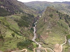
The river Lawriqucha (center) just before its confluence with the Nupe River (on the right)
|
|
| Country | Peru |
| Region | Huánuco |
| Physical characteristics | |
| River mouth | Marañón River |
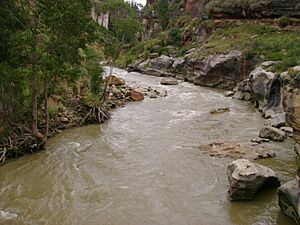
The Lawriqucha River is an important river in the Huánuco Region of Peru. Its name comes from the Quechua language. Lawri means bluish, and qucha means lake or lagoon. So, Lawriqucha means "bluish lake." This river is part of the larger Marañón River system. The river itself is named after a lake called Lawriqucha or Lauricocha.
Contents
Where Does the Lawriqucha River Start?
The Lawriqucha River begins in a small lake high up in the mountains. This lake is called Niñococha (10°27′29″S 76°45′50″W / 10.458°S 76.764°W). It is a glacial lake, meaning it was formed by glaciers. Niñococha is located in the Raura mountain range at a very high elevation of about 4,964 meters (16,286 feet).
In 1952, an English explorer named Sebastian Snow thought this lake was the true source of the Amazon River. However, many different places have been suggested as the Amazon's source over time.
The River's Journey
From Niñococha, the Lawriqucha River flows north. It passes by the Raura silver mine. Then, it reaches Lake Lauricocha, which is where it gets its name.
Near Lake Lauricocha, you can find some amazing historical sites:
- Ancient Bridge: There is a stone bridge over the river that was built by the Inca Empire. It is still used today by people traveling on foot or with horses!
- Lauricocha Caves: Close by are the Lauricocha caves. Archaeologists have found signs that people lived in these caves about 10,000 years ago. This shows how long humans have been in this area.
The river continues its journey north. It flows near several small villages. These include Cauri (also known as Kawri), Jesús, and Jivia.
Where Does the River End?
The Lawriqucha River eventually reaches the town of Rondos (also called Runtus). Here, it meets another river called the Nupe River. When the Lawriqucha and Nupe rivers join together, they form the mighty Marañón River. This meeting point is at an elevation of about 3,318 meters (10,886 feet).
The total length of the Lawriqucha River is about 50 kilometers (31 miles). This is measured in a straight line from Niñococha Lake to where it joins the Nupe River.
See also
 In Spanish: Río Lauricocha para niños
 | Roy Wilkins |
 | John Lewis |
 | Linda Carol Brown |


