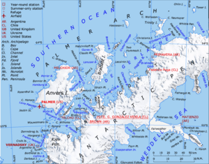
A map of Gerlache Strait including Lemaire Island
Lemaire Island is a cool place in Antarctica, a continent covered in ice at the bottom of the world! It's an island about 4.5 nautical miles (which is about 8.3 kilometers) long and 1.5 nautical miles (about 2.8 kilometers) wide. You can find it about 1 nautical mile (about 1.9 kilometers) west of a spot called Duthiers Point. This area is off the west coast of Graham Land, which is part of the Antarctic Peninsula.
Discovering Lemaire Island
This island was first found by explorers from the Belgian Antarctic Expedition. This journey happened between 1897 and 1899. The expedition was led by a brave explorer named Adrien de Gerlache. He decided to name the island after Charles Antoine Lemaire.
Where is Lemaire Island?
Lemaire Island is located near the Danco Coast. It is separated from this coast by a waterway called the Aguirre Passage. The island is part of the Palmer Archipelago, a group of islands near the Antarctic Peninsula.
Siebert Rock: A Special Landmark
The southwest tip of Lemaire Island has a special landmark called Siebert Rock. This rock sits right at the entrance to the Lientur Channel. Siebert Rock was first mapped out by the Chilean Antarctic Expedition during their trip in 1950–51. They named it after Capitan de Corbeta Ernesto Siebert G. He was an engineer officer on their expedition ship, the Angamos.


