Lessard River (Chaudière River tributary) facts for kids
Quick facts for kids Lessard River |
|
|---|---|

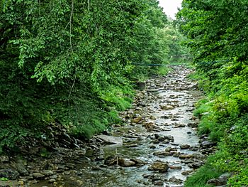
Lessard River at Vallée-Jonction.
|
|
| Native name | Rivière Lessard |
| Country | Canada |
| Province | Quebec |
| Administrative region | Chaudière-Appalaches |
| RCM | Robert-Cliche Regional County Municipality, La Nouvelle-Beauce Regional County Municipality |
| Physical characteristics | |
| Main source | Mountain and agricultural streams Saint-Séverin 593 metres (1,946 ft) 46°18′16″N 71°03′26″W / 46.304347°N 71.05734°W |
| River mouth | Chaudière River Vallée-Jonction 139 metres (456 ft) 46°23′07″N 70°57′05″W / 46.38528°N 70.95139°W |
| Length | 14.4 kilometres (8.9 mi) |
| Basin features | |
| Progression | Chaudière River, St. Lawrence |
| Tributaries |
|
The Lessard River (in French: rivière Lessard) is a river in Quebec, Canada. It flows into the Chaudière River, which then empties into the St. Lawrence River. The Lessard River runs through the towns of Saint-Séverin and Vallée-Jonction. It is located in the Chaudière-Appalaches region of Quebec.
Where the Lessard River Flows
The Lessard River starts in the municipality of Saint-Séverin. Its source is on the northern side of a mountain. This starting point is about 5.9 kilometres (3.7 mi) north-west of the village of Saint-Frédéric. It is also about 2.2 kilometres (1.4 mi) east of the village of Saint-Séverin.
River's Journey
The Lessard River flows for about 14.4 kilometres (8.9 mi). It travels mostly north and east.
- First, it goes 2.6 kilometres (1.6 mi) north, then east, in Saint-Séverin.
- Next, it flows 4.9 kilometres (3.0 mi) north-east.
- Then, it continues 2.0 kilometres (1.2 mi) north-east.
- After that, it goes 1.9 kilometres (1.2 mi) north-east, reaching the edge of Saint-Joseph-des-Érables.
- Finally, it flows 3.0 kilometres (1.9 mi) eastward until it joins another river.
About three kilometers before it joins the Chaudière River, there is a spot called "Chute à Corinne." This means "Corinne's Fall." The river then flows through a narrow valley. This valley is surrounded by hills made of sand and gravel. Many quarries use these natural resources in the area.
Where the River Ends
The Lessard River empties into the Chaudière River. This happens on the west bank of the Chaudière River, near Saint-Joseph-des-Érables. This meeting point is about 2.1 kilometres (1.3 mi) downstream from the bridge in Vallée-Jonction. It is also about 8.1 kilometres (5.0 mi) upstream from Sainte-Marie-de-Beauce.
What's in a Name?
The Lessard River wasn't always called that. In 1785, it was known as "Rivière du Tabord." This name might have come from Mount Tabor. This is a mountain in Israel where an important event in Christian history happened.
The name "Lessard River" came about because many families named Lessard owned land nearby. In 1819, two important landowners built a flour mill on land belonging to François Lessard. Since then, the name "Lessard" has been used for the river on maps and in documents.
The name "rivière Lessard" became official on December 5, 1968. This was decided by the Commission de toponymie du Québec, which is like a naming committee for places in Quebec.
 | Georgia Louise Harris Brown |
 | Julian Abele |
 | Norma Merrick Sklarek |
 | William Sidney Pittman |


