Liemeer facts for kids
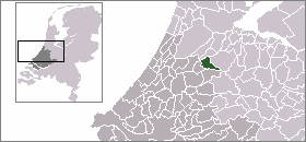
Liemeer was a small area in the western part of the Netherlands. It was once a "municipality," which is like a local government area or a group of towns managed together. Liemeer stopped being a separate municipality on January 1, 2007. At that time, it joined with another area called Nieuwkoop.
Contents
What Was Liemeer?
Liemeer was a special kind of local government area in the South Holland province of the Netherlands. Think of a municipality as a town or a group of towns that work together to manage local services.
Where Was Liemeer Located?
Liemeer was found in the western part of the Netherlands. This country is famous for its windmills, canals, and flat landscapes. The province of South Holland is one of the busiest and most populated areas in the Netherlands.
How Big Was Liemeer?
The total area of Liemeer was about 30.98 square kilometers (about 12 square miles). A small part of this area, about 0.76 square kilometers, was covered by water. In November 2006, just before it merged, about 6,962 people lived in Liemeer.
What Towns Were Part of Liemeer?
Liemeer was made up of several smaller communities. These included:
- Nieuwveen
- Noorden
- Vrouwenakker
- Zevenhoven
These towns worked together under the Liemeer municipality.
When Did Liemeer Exist?
The municipality of Liemeer wasn't always called Liemeer. It was actually established in 1994. Before that, the area was known as Nieuwveen. So, in 1994, the name changed from Nieuwveen to Liemeer.
Why Did Liemeer Merge?
On January 1, 2007, Liemeer merged with the nearby municipality of Nieuwkoop. This often happens in the Netherlands. Smaller municipalities sometimes combine to form larger ones. This can help them manage resources better and provide services more efficiently.
 | James Van Der Zee |
 | Alma Thomas |
 | Ellis Wilson |
 | Margaret Taylor-Burroughs |


