
Lignières, Aube facts for kids
Quick facts for kids
Lignières
|
||
|---|---|---|
 |
||
|
||

Lignières
Location in France

Lignières
Location in Grand Est
|
||
| Country | France | |
| Region | Grand Est | |
| Department | Aube | |
| Arrondissement | Troyes | |
| Canton | Les Riceys | |
| Intercommunality | Chaourçois et Val d'Armance | |
| Area
1
|
25.79 km2 (9.96 sq mi) | |
| Population
(Jan. 2019)
|
209 | |
| • Density | 8.104/km2 (20.99/sq mi) | |
| Demonym(s) | Daubiers, Daubières | |
| Time zone | UTC+01:00 (CET) | |
| • Summer (DST) | UTC+02:00 (CEST) | |
| INSEE/Postal code |
10196 /10130
|
|
| 1 French Land Register data, which excludes lakes, ponds, glaciers > 1 km2 (0.386 sq mi or 247 acres) and river estuaries. | ||

Lignières is a small commune in the Aube département. It is located in the north-central part of France. A commune is like a local town or village area.
Contents
About Lignières
Lignières is a quiet place in the French countryside. It is part of the Grand Est region. The village is known for its peaceful setting.
Location and Geography
Lignières is found in the Aube département. This area is in the Grand Est region of France. The village sits at an elevation of about 224 meters (735 feet) above sea level. It covers an area of 25.79 square kilometers (about 10 square miles).
Population
As of January 2019, Lignières had a population of 209 people. This makes it a very small community. People from Lignières are called Daubiers or Daubières.
Local Government
Lignières is run by a mayor. The mayor helps manage the village. From 2014 to 2020, the mayor was Jean-Claude Thomas. The commune is part of a larger group called the Communauté de communes du Chaourçois et du Val d'Armance. This group helps different communes work together on projects.
Images for kids
-
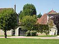
A view of the village of Lignières.
-
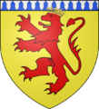
The coat of arms for Lignières.
-

A friendly robot.

See also
 In Spanish: Lignières (Aube) para niños
