
List of Indiana state historical markers in Marshall County facts for kids

Have you ever seen a special sign by the road that tells you about something important that happened long ago? These signs are called historical markers. They help us learn about the past and remember important people, places, or events.
In Marshall County, Indiana, there are three official state historical markers. These markers were placed by the Indiana Historical Bureau. They tell us about exciting parts of history right here in Marshall County. Let's explore what these markers teach us!
Historical Markers in Marshall County
Historical markers are like outdoor history lessons. They are usually made of metal and have words carved into them. They are placed in the exact spot where something important happened. This helps people who visit the location understand its history better.
These markers remind us of the stories of the past. They can be about brave pioneers, important battles, or even how our towns and roads were first created. Each marker helps keep history alive for future generations.
Important Markers in Marshall County
Marshall County is home to three unique historical markers. Each one tells a different story about the area's rich past.
The Trail of Death
One of the markers in Marshall County remembers a sad event called the Trail of Death. This marker was placed in 1949. It is located near the junction of State Road 17 and County Road 12, west of Twin Lakes.
The Trail of Death was a forced journey in 1838. About 859 Potawatomi people were made to leave their homes in Indiana. They were forced to walk over 660 miles to Kansas. Many people, especially children, became sick and died during this difficult journey. This marker helps us remember the Potawatomi people and the hardships they faced.
The Second Principal Meridian
Another important marker is about the Second Principal Meridian. This marker was placed in 1966. You can find it about 1.6 miles west of the junction of State Roads 17 and 110.
What is a "meridian"? It's an imaginary line that runs north and south. The Second Principal Meridian was a very important line. It was used by surveyors to measure and divide land in Indiana and other states. When pioneers moved west, they needed a way to buy and sell land fairly. This meridian helped create the maps and property lines we still use today. It played a big role in how Indiana was settled.
Benack's Village
The newest marker in Marshall County is for Benack's Village. It was placed in 2011. This marker is located at the Potawatomi Wildlife Park in Bourbon, Indiana.
Benack's Village was an important settlement for the Potawatomi people. It was led by a chief named Benack. This village was a center of Potawatomi life and culture before they were forced to leave their lands. The marker helps us remember the vibrant communities that existed long before European settlers arrived. It also reminds us of the rich history of the Native American people in this area.
Images for kids
-
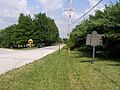
The historical marker for the Trail of Death.
_P6250302.jpg)
See also
- List of Indiana state historical markers
- National Register of Historic Places listings in Marshall County, Indiana
