
National Register of Historic Places listings in Marshall County, Indiana facts for kids

This page is a list of amazing places in Marshall County, Indiana, that are special enough to be on the National Register of Historic Places. Think of it like a national hall of fame for buildings, areas, and sites that are important to history!
The National Register of Historic Places is an official list kept by the United States government. It helps protect places that are important because of their history, architecture, or what happened there. When a place is on this list, it means it's recognized as a valuable part of our country's past.
In Marshall County, there are 32 different places and areas that are currently on this special list. There were also 3 other places that used to be on the list but have since been removed. Some of these places are in towns, and some are in the countryside.
Contents
What is the National Register of Historic Places?
The National Register of Historic Places is like a special club for buildings, neighborhoods, and other sites that have a lot of history. It's managed by the National Park Service, which is part of the U.S. government.
Why are places listed?
Places get listed for many reasons. Maybe they are:
- Very old: Like a house built a long time ago that shows how people lived.
- Beautifully designed: Buildings with unique or important architectural styles.
- Connected to important events: A place where something big happened in history.
- Linked to famous people: A home or workplace of someone important.
When a place is on the list, it helps people understand its value. It also offers some protection and can help with getting grants for repairs.
Historic Places in Marshall County
Marshall County has many interesting places on the National Register. Let's explore some of them!
Argos Historic Spots
The town of Argos has a few places on the list.
- Argos Downtown Historic District: This is a whole area in the center of Argos. It includes many buildings along Michigan Street that show what the town looked like long ago. It was added to the list in 2001.
- Argos Izaak Walton League Historic District: This spot is east of Argos. It's connected to the Izaak Walton League, a group that works to protect nature and outdoor spaces. This district was listed in 2011.
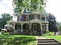
- Lewis and Sarah Boggs House: North of Argos, this old house was added to the list in 2012. It's a great example of homes from its time.
Bourbon's Community Building
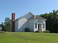
In Bourbon, you'll find the Bourbon Community Building-Gymnasium. This building has been an important gathering place for the community for many years. It was listed in 2015.
Bremen's Historic Areas
The town of Bremen has several historic places.
- Bremen Commercial Historic District: This area includes the main business streets of Bremen. It shows how the town's businesses grew over time. It was listed in 2017.
- Bremen Residential Historic District: This district covers a neighborhood with many historic homes. It gives us a peek into how people lived in Bremen in the past. It was also listed in 2017.
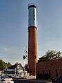
- Bremen Water Tower: This tall water tower is a landmark in Bremen. It's not just for water; it's also a historic structure! It was added to the list in 2013.
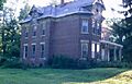
- Dietrich-Bowen House: This historic house in Bremen was listed way back in 1978. It's one of the older listings in the county.
Culver's Lakeside Charm
Culver is known for its beautiful lake, and it has several historic spots.
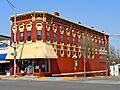
- Culver Commercial Historic District: This area covers the main business part of Culver. It shows the history of shops and services in the town. It was listed in 1996.
- East Shore Historic District: This district is along the east side of Lake Maxinkuckee near Culver. It includes historic homes and the Maxinkuckee Country Club, showing how people enjoyed the lake in the past. It was listed in 1998.
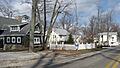
- Forest Place Historic District: This charming area in Culver, between College Avenue and Lake Shore Drive, was listed in 2000. It's known for its historic homes and peaceful setting.
Plymouth's Landmarks
Plymouth is the county seat, and it has many historic buildings.
- East Laporte Street Footbridge: This bridge crosses the Yellow River in Plymouth. It's a historic way for people to cross the river and was listed in 1981.
- Heminger Travel Lodge: This old lodge on Lincolnway East was a place for travelers to stay. It was listed in 2001, showing a piece of travel history.
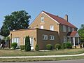
- Hoham-Klinghammer-Weckerle House and Brewery Site: This unique property includes a historic house and the site of an old brewery. It was listed in 2012.
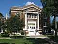
- Jacoby Church and Cemetery: East of Plymouth, this historic church and its cemetery tell stories of early settlers. It was listed in 2007.
- Marshall County Courthouse: Located in the heart of Plymouth, this beautiful building is where many important county decisions are made. It's a major landmark and was listed in 1983.
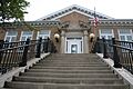
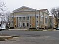
- Marshall County Infirmary: Southeast of Plymouth, this building once served as a place for people needing care. It was listed in 2000.
- Plymouth Downtown Historic District: This large area covers the main part of downtown Plymouth, including many historic buildings along Center, Washington, and Water Streets. It was listed in 1998.
- Plymouth Northside Historic District: This district includes streets north of the courthouse square, with many historic homes and buildings. It was listed in 2013.
- Plymouth Southside Historic District: South of downtown, this area along Michigan Street also has many historic buildings. It was listed in 2013.
- Plymouth Fire Station: This historic fire station in Plymouth was listed in 1981. It's a cool example of old fire department buildings.
Other Notable Marshall County Sites
- Erwin House: Located in Tippecanoe Township, this house was listed in 2016.
- Gaskill-Erwin Farm: Also in Tippecanoe Township, this historic farm was listed in 2015. It shows how farming has changed over time.
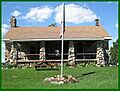
- Chief Menominee Memorial Site: Southwest of Plymouth, this site honors Chief Menominee, a leader of the Potawatomi people. It's a very important historical and cultural site, listed in 2010.
- Norris Farm-Maxinkuckee Orchard: In Union Township, this farm and orchard were listed in 2016. It represents the agricultural history of the area.
- Polk Township District No. 2 School: Southeast of Walkerton, this old schoolhouse was listed in 2013. It reminds us of how education used to be.
- Ramsay-Fox Round Barn and Farm: West of Plymouth, this unique round barn and farm were listed in 2012. Round barns are rare and interesting!
- Tippecanoe Twp. District No. 3 Schoolhouse and Cemetery: Northeast of Tippecanoe, this schoolhouse and cemetery were listed in 2008. It's another example of early education in the county.
Former Listings
Sometimes, a place might be removed from the National Register of Historic Places. This usually happens if the building is changed too much or is no longer standing.
- Marshall County Jail: This old jail in Plymouth was listed in 1973 but was removed in 1983.
- Woodbank: This property near Lake Maxinkuckee was listed in 1982 but was removed in 2014.
Images for kids
-
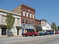
Buildings in the Argos Downtown Historic District.
-
The clubhouse at the Argos Izaak Walton League Historic District.
-
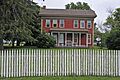
The historic Lewis and Sarah Boggs House.
-
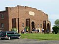
The Bourbon Community Building-Gymnasium.
-
The Bremen Water Tower.
-
A building in the Culver Commercial Historic District.
-
The Dietrich-Bowen House in Bremen.
-

The East Laporte Street Footbridge over the Yellow River.
-
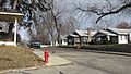
A view of East Lake Shore Drive near Lake Maxinkuckee.
-

The Erwin House.
-
A street view in the Forest Place Historic District.
-

The farmhouse at Gaskill-Erwin Farm.
-
The Heminger Travel Lodge.
-
The Hoham-Klinghammer-Weckerle House.
-
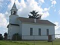
Jacoby Church.
-

The Marshall County Courthouse in Plymouth.
-
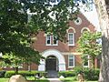
The entrance to the Marshall County Infirmary.
-
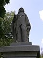
A statue at the Chief Menominee Memorial Site.
-
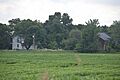
Norris Farm.
-
A street in the Plymouth Downtown Historic District.
-
First United Methodist Church in the Plymouth Northside Historic District.
-
Trinity UMC in the Plymouth Southside Historic District.
-
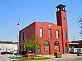
The Plymouth Fire Station.
-

The entrance to Polk Township District No. 2 School.
-
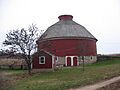
The Ramsay-Fox Round Barn.
-
The Tippecanoe Twp. District No. 3 Schoolhouse.
-
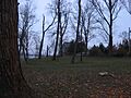
The site where Woodbank once stood.


