Yellow River (Indiana) facts for kids
Quick facts for kids Yellow River |
|
|---|---|

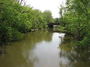
The Yellow River in Knox in 2006
|
|
|
Location of the mouth of the Yellow River in Starke County, Indiana
|
|
| Country | United States |
| State | Indiana |
| Physical characteristics | |
| Main source | St. Joseph County 804 ft (245 m) 41°29′54″N 86°09′08″W / 41.49833°N 86.15222°W |
| River mouth | Kankakee River Starke County 656 ft (200 m) 41°16′16″N 86°49′35″W / 41.27111°N 86.82639°W |
| Length | 62 mi (100 km)approx. |
| Basin features | |
| Basin size | 427 sq mi (1,110 km2) |

The Yellow River is a river in northern Indiana, United States. It flows for about 62 miles (100 km). This river is a tributary of the Kankakee River. It is part of the larger Mississippi River system. The Yellow River helps drain an area of about 427 square miles (1,106 sq km). Its name might come from the Shawnee language word We-thau-ka-mik. This word means "yellow waters," possibly because of the sand in the riverbed.
Contents
Where Does the Yellow River Flow?
The Yellow River starts in southeastern St. Joseph County. It begins where several farm ditches meet. The river first flows south into Marshall County, passing by the town of Bremen.
Then, it generally flows southwest. It goes back to its natural curvy path through the city of Plymouth. After Plymouth, it flows west in a mostly straight path through Starke County. It passes the city of Knox. Finally, it joins the Kankakee River in southwestern Starke County. This is about 10 miles (16 km) west of Knox, near English Lake.
The Yellow River's Water System
The Yellow River's water system is connected to many other rivers. To the north, it is near the St. Joseph River. This river flows into Lake Michigan. To the east, the Elkhart River also flows into the St. Joseph River. All these waters eventually reach the Atlantic Ocean through the Saint Lawrence River.
To the south and southeast, the Yellow River is bordered by the Tippecanoe River. The Tippecanoe River flows south into the Wabash River. The Wabash River then empties into the Ohio River, which flows into the Mississippi River. The Mississippi River then reaches the Gulf of Mexico.
To the southwest, you find the Iroquois River. This river is also a tributary of the Kankakee River, just like the Yellow River. The Yellow River is the second-largest river that flows into the Kankakee. The Iroquois River is larger and joins the Kankakee in Illinois. The Kankakee River then meets the Des Plaines River in Illinois. Together, they form the Illinois River, which flows into the Mississippi River.
History of the Yellow River Area
The area around the Yellow River has a rich history, especially involving Native American tribes.
The Potawatomi People and Their Leaders
The Potawatomi people lived along the Yellow River for a long time. Several important leaders came from this area.
Main Poc: A Warrior and Chief
Main Poc was a famous warrior and chief of the Yellow River Potawatomi. He became well-known around 1795. Main Poc led raiding parties across the Mississippi River. By 1804, he and another chief, Turkey Foot, were leading raids throughout the Midwest. They even went as far as Tennessee and Kentucky.
In 1807, Tecumseh and his brother, the Prophet, came to Indiana. Main Poc joined their plan to stop white settlers from taking more land. After Main Poc moved to Prophetstown in 1809, the Yellow River area became more peaceful. Main Poc returned to the Yellow River after 1814 and died in 1816.
Menominee: A Religious Leader
By 1814, Menominee was an important leader of the Twin Lakes Potawatomi. He was a religious chief. In 1820, he invited a missionary named Isaac McCoy to the Yellow River. Menominee wanted to combine the teachings of Tecumseh and the Prophet with Roman Catholicism. He hoped this would help his people deal with the increasing number of settlers.
In the 1830s, a Roman Catholic Mission took over. This mission expanded to the Yellow River Potawatomi in 1833. These two communities became strong centers of resistance against being forced to move.
Potawatomi Villages and Treaties
By 1830, there were three main Potawatomi villages on the Yellow River. Each had its own chief. Notawkah (Rattlesnake) led the village east of the Yellow River. Mackahtahmoah (Black Wolf) was chief of the western village. Pepinawah was another chief in these villages.
In 1832, some Potawatomi chiefs signed a treaty with the U.S. government. This treaty set aside 14,000 acres (57 sq km) near the Yellow River for the Potawatomi forever. However, this land was later sold in the 1836 Treaty of Yellow River. This treaty said that all Potawatomi people had to move west of the Mississippi River within two years.
Chief Menominee refused to sign any treaty that gave away Native American lands. Despite his refusal, the land was taken. When the Potawatomi of Indiana were being gathered to be moved west, Menominee's village became a meeting place for those who did not want to go.
On September 4, 1838, Menominee's band of 859 people were forced to march to Kansas. This sad event is known as the Potawatomi Trail of Death.
Changes to the Yellow River's Path
Over time, people have changed parts of the Yellow River.
Draining English Lake
When European settlers arrived, the area where the Yellow and Kankakee Rivers met was a large, marshy wetland. It was called English Lake and was seven miles (11 km) long. By the 1910s, the lower Yellow River was made into a straight channel. The wetland was drained and turned into farmland.
In 1933, the state of Indiana created the Kankakee State Fish and Wildlife Area. This area was on a strip of land between the straightened Yellow and Kankakee channels. It was then changed back into marshland.
Straightening the River
The section of the Yellow River in Starke County used to be a winding, swampy stream with many oxbow lakes (U-shaped lakes). In 2004, the United States Army Corps of Engineers worked on this straightened part of the river. They wanted to fix the problem of too much mud building up in the riverbed because of the changes made to its path.
Towns and Cities Along the Yellow River
 | John T. Biggers |
 | Thomas Blackshear |
 | Mark Bradford |
 | Beverly Buchanan |


