
List of Pennsylvania state historical markers in Dauphin County facts for kids

Have you ever seen a special sign by the road that tells a story about the past? These are called historical markers! In Dauphin County, Pennsylvania, there are many of these signs, placed by the Pennsylvania Historical and Museum Commission (PHMC). They help us learn about important people, places, and events that happened right here. Dauphin County has 81 of these cool markers, each sharing a piece of history.
Contents
Discovering History in Dauphin County
Historical markers are like outdoor history books. They are special signs that the Pennsylvania Historical and Museum Commission puts up. These signs tell us about important moments, famous people, and interesting places in Pennsylvania's past. They help everyone, especially young people, connect with history where it actually happened.
What Are Historical Markers?
Imagine walking down a street and seeing a sign that tells you a famous president once visited that spot, or that a big battle happened nearby. That's what historical markers do! They are usually made of metal and have words carved into them. Each marker shares a short, exciting story about something significant. They make learning about history fun and easy to find.
Exploring Dauphin County's Past
Dauphin County is full of history, and its markers show us many different stories. From important leaders to big events, these markers cover a lot. Let's look at a few examples of the interesting things you can discover:
Leaders and Important People
- Abraham Lincoln: A marker in Harrisburg remembers President Abraham Lincoln. He was a very important leader during the American Civil War.
- C. DeLores Tucker: This marker honors C. DeLores Tucker, a strong voice for civil rights and women's rights in the 20th century. She worked hard to make things fair for everyone.
- Milton S. Hershey: You might know the name Hershey from chocolate! A marker celebrates Milton S. Hershey, who founded the famous chocolate company and built the town of Hershey. He was a great businessman and helped many people.
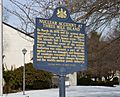
- William Howard Day: This marker tells about William Howard Day, an important African American leader. He fought for education and civil rights and was involved with the Underground Railroad.
Battles and Forts
- Barnett's Fort: During the French and Indian War, forts like Barnett's Fort were important for protection. This marker reminds us of those early days and the challenges settlers faced.
- Camp Curtin: This was a huge training camp during the Civil War. Thousands of soldiers came here before going off to fight. The marker helps us remember their bravery.
- Fort Halifax: Another fort from the French and Indian War, Fort Halifax, was a key defense point. Markers show where these important military sites once stood.
Big Events and Places
- Chocolate Workers' Sit-down Strike: In Hershey, a marker tells the story of workers who went on strike to ask for better conditions. This was an important moment for labor rights.
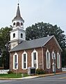
- Derry Church: This old church has a long history, going back to early settlers. Its marker shares stories about religion and community in the past.
- Millersburg Ferry: This marker celebrates the Millersburg Ferry, which has been carrying people and goods across the Susquehanna River for a very long time. It's a unique way to travel!
- Nuclear Accident at Three Mile Island: A marker near Royalton explains the important event of the Three Mile Island accident. It reminds us about the history of nuclear power and its impact.
- Rockville Bridge: This amazing bridge is one of the longest stone arch bridges in the world. A marker celebrates its history and importance for railroads.
- Underground Railroad: Several markers in Harrisburg highlight the Underground Railroad. This was a secret network that helped enslaved people find freedom. These markers honor the brave people who risked everything for liberty.
Images for kids
-

Abraham Lincoln
-
Barnett's Fort
-
Burd Tombs
-
C. DeLores Tucker (1927-2005)
-
Camel Back Bridge
-
Camp Curtin
-
Camp George Gordon Meade
-
Chocolate Workers' Sit-down Strike
-
Col. James Burd
-
Col. Timothy Green
-
Dauphin County
-
Derry Church
-
Derry Churchyard
-
Eagle Hotel
-
Executive Mansion
-
Executive Mansion
-
Fort Halifax
-
Fort Halifax - PLAQUE
-
Fort Hunter
-
Fort Hunter - PLAQUE
-
Fort Manada
-
Genevieve Blatt
-
Governor's Residence
-
Governor's Residence
-
Grace Methodist Church
-
Hanover Church
-
Hanover Resolves
-
Harris' Ferry
-
Harrisburg
-
Harrisburg
-
Harrisburg
-
Harrisburg
-
Harrisburg
-
Harrisburg Cemetery
-
Harrisburg Giants
-
Harrisburg State Hospital
-
Hershey
-
Hummelstown Brownstone Quarries
-
J. Donald Cameron
-
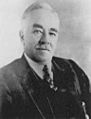
J. Horace McFarland
-
John Harris' Gift
-
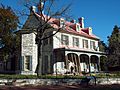
John Harris Mansion
-
Lincoln Cemetery
-
Market Square
-
Middletown
-
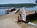
Millersburg Ferry
-
Milton S. Hershey
-
Mira Lloyd Dock
-
Nuclear Accident at Three Mile Island
-
Old Brick Capitol
-
Old Courthouses
-
Old Salem Church
-
Patton's Fort
-
Paxtang Manor
-
Paxton Church
-
Paxton Church
-
Paxton Riflemen
-
Pennsylvania Canal
-
Pennsylvania Canal (Eastern Division)
-
Pennsylvania Canal (Juniata Division)
-
Pennsylvania Farm Show
-
Pennsylvania State Archives
-
Pennsylvania State Police
-
Presidential Convention
-
Public Sector Unionism
-
Rockville Bridge
-
Saint Peter's Kierch
-
Simon Girty
-
State Capitol
-
State Museum of Pennsylvania
-
T. Morris Chester
-
U.S. Colored Troops Grand Review
-
Underground Railroad
-
Union Canal
-
Union Canal
-
Union Canal
-
Walnut Street Bridge
-
Wildwood Park
-
William Howard Day
-
William Maclay
-

Wilt Chamberlain's Scoring Record


See also
- List of Pennsylvania state historical markers
- National Register of Historic Places listings in Dauphin County, Pennsylvania
