
List of Pennsylvania state historical markers in Fulton County facts for kids

Have you ever seen those signs along the road that tell you about important places or events from the past? These are called historical markers! They help us learn about the history of an area. This article is all about the special historical markers you can find in Fulton County, Pennsylvania.
These markers are placed by the Pennsylvania Historical and Museum Commission (PHMC). They are like outdoor history books, showing us where cool things happened or where important people lived. Fulton County has 11 of these markers, each telling a unique story about its past. Let's explore some of them!
Contents
Stories from the Past
Fulton County is full of history, from early Native American life to important events during the Civil War. These markers help us remember and understand these stories.
Native American History
Long before settlers arrived, Native American tribes lived in the area that is now Fulton County. Two markers tell us about their presence:
Burnt Cabins
The marker for Burnt Cabins tells a sad but important story. In 1750, some early European settlers built cabins on land that was still claimed by Native American tribes. The Native Americans complained to the colonial government. To keep peace, the government ordered the cabins to be burned down. This event gave the area its unique name. It reminds us of the complex history between Native Americans and early settlers.
Big Spring Graveyard
The Big Spring Graveyard marker points to a historic burial ground. This site is important because it shows where Native Americans lived and were buried many years ago. It helps us remember the people who were here first and their connection to the land.
Military History and Old Roads
Fulton County played a role in several wars, and its roads were important for travel and defense.
Forbes Road
The Forbes Road marker highlights a very old and important path. This road, also known as the Raystown Path, was built during the French and Indian War (1754-1763). It was a military road used by British and colonial forces, led by General John Forbes, to reach and capture Fort Duquesne (which is now Pittsburgh). Imagine soldiers and supplies moving along this very path hundreds of years ago! It was a major transportation route for its time.
Fort Littleton
There are two markers for Fort Littleton, one a plaque and one a roadside marker. This fort was built in 1756 during the French and Indian War. It was one of a chain of forts designed to protect Pennsylvania's frontier settlers from attacks. Soldiers stationed here helped guard the western edge of the colony. It was named after Sir George Lyttelton, a British official. These markers show us where this important defensive outpost once stood.
The Civil War in Fulton County
Fulton County was close to many key events during the American Civil War (1861-1865). Several markers remember this time.
Gettysburg Campaign
The Gettysburg Campaign marker reminds us that Fulton County was part of the famous Gettysburg Campaign in 1863. This was when Confederate (Southern) troops, led by General Robert E. Lee, marched through Pennsylvania on their way to the Battle of Gettysburg. Union (Northern) forces also moved through the area. The marker shows how close the war came to the people of Fulton County.
Last Confederate Bivouac
There are also two markers for the Last Confederate Bivouac. A "bivouac" is a temporary camp without tents. These markers show where Confederate soldiers camped just before the Battle of Gettysburg. It was one of their last stops before the major battle. This helps us understand the movements of the armies during this critical time in American history.
Confederate Dead
The Confederate Dead marker is a reminder of the soldiers who died during the Civil War. It points to a burial site for Confederate soldiers who passed away in the area, often from wounds or sickness. It's a somber reminder of the human cost of war.
Local Industry and Government
Historical markers also tell us about the everyday life and development of Fulton County.
Hunter Mill
The Hunter Mill marker tells us about an old mill located near Webster Mills. Mills were very important in early communities. They used water power to grind grain into flour, which was a basic food item. This marker highlights the early industries that helped communities grow and thrive.
Fulton County
The Fulton County marker is located at the County Courthouse in McConnellsburg. It celebrates the establishment of Fulton County itself. The county was formed in 1850 from parts of Bedford County. This marker tells us about the local government and how the county came to be.
Images for kids
-
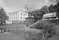
The historic Burnt Cabins Gristmill, near one of the historical markers.

See also
- List of Pennsylvania state historical markers
- National Register of Historic Places listings in Fulton County, Pennsylvania
