
List of Pennsylvania state historical markers in Potter County facts for kids

Welcome to Potter County, Pennsylvania! This area is full of history, and you can learn about it by visiting special signs called historical markers. These markers are like outdoor history books, placed by the Pennsylvania Historical and Museum Commission (PHMC) to tell us about important events, people, or places.
In Potter County, there are 11 official state historical markers. Each one shares a unique story about the past, from natural disasters to famous people and early settlements. Let's explore some of these fascinating markers and what they teach us!
Contents
Amazing Stories from Potter County's Past
Potter County has many interesting stories marked by these special signs. They help us remember what happened long ago and why it's still important today.
The Austin Flood Disaster
One of the most dramatic events in Potter County's history is remembered by the Austin Flood Disaster marker.
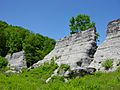
- What happened? On September 30, 1911, a large dam near the town of Austin broke. This caused a terrible flood that rushed through the town.
- Why was it important? The flood destroyed much of Austin and sadly, many lives were lost. This event was a huge tragedy for the community. The marker helps people remember the flood and its impact on the town and its people. It's a reminder of the power of nature.
- Where is it? You can find this marker on PA 872, about 2 miles north of Austin, right at the site of the disaster.
Ole Bull's Colony
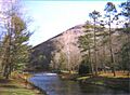
Another fascinating story is about Ole Bull's Colony.
- Who was Ole Bull? Ole Bull was a famous Norwegian violinist and composer. He was a very talented musician!
- What was his colony? In 1852, Ole Bull tried to create a new home for Norwegian immigrants in Potter County. He bought a lot of land, hoping to build a thriving community where people could live and work together.
- Why did it fail? Unfortunately, the colony didn't last very long. There were problems with the land titles, and the settlers faced many challenges. Even though it failed, the idea of the colony shows a unique part of Pennsylvania's immigration history.
- Where is it? This marker is on Cherry Springs Road (PA 44), near West Branch Road, close to Cherry Springs State Park.
David Zeisberger: A Missionary's Journey
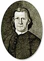
You'll find several markers dedicated to David Zeisberger, an important missionary.
- Who was he? David Zeisberger was a Moravian missionary. He spent much of his life working with Native American communities in Pennsylvania and other areas.
- What did he do? He traveled widely, sharing his religious beliefs and living among different Native American tribes. He learned their languages and tried to build peaceful relationships.
- Why so many markers? Because he traveled so much through Potter County, several markers show the different places he visited or where his work had an impact. One special marker is a plaque at the County Courthouse in Coudersport.
- Where are they? You can find these markers in places like East Main Street (PA 49) near Harrison Valley, PA 49 near Raymond, and in Coudersport at 2nd Street (US 6) by the Allegheny River. The plaque is at the County Courthouse in Coudersport.
The Allegheny River
The Allegheny River also has its own marker.
- What is the Allegheny River? It's a major river that starts in Potter County! It flows north into New York before turning south and joining with the Monongahela River in Pittsburgh to form the Ohio River.
- Why is it important? Rivers like the Allegheny were super important for Native Americans and early settlers. They were used for travel, fishing, and as a source of water. This marker reminds us of the river's role in the environment and transportation history of the area.
- Where is it? This marker is on PA 49 near Smith Road, about 11 miles northeast of Coudersport.
Historic Roads and Towns
Other markers tell us about how people traveled and where they lived.
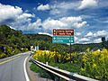
- Jersey Shore Pike: This marker tells the story of an old road that was important for transportation in the past. It's located on Grand Army of the Republic Highway (US 6), east of Coudersport.
- Lymansville: This marker highlights the history of Lymansville, one of the towns in Potter County. It's found at the junction of US 6 and PA 872, east of Coudersport.
- Potter County: There's a marker specifically for Potter County itself, located at the County Courthouse in Coudersport. It talks about the county's government and its history since the 1800s.
- Pennsylvania: A marker in Genesee celebrates the state of Pennsylvania, reminding us of its founding and early government in the 17th century, including the role of William Penn.
These historical markers are like clues to the past, helping us understand the rich history of Potter County and the people who lived here long ago!
Images for kids
-

Placeholder image
-
The ruins of the Austin Dam after the 1911 flood.
-
A portrait of David Zeisberger, the missionary.
-
A crossroads in Abbott Township, representing the Jersey Shore Pike.
-
Kettle Creek, near the site of Ole Bull's Colony.
-

The flag of Pennsylvania.
-
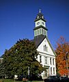
The Potter County Courthouse in Coudersport.


See also
- List of Pennsylvania state historical markers
- National Register of Historic Places listings in Potter County, Pennsylvania
