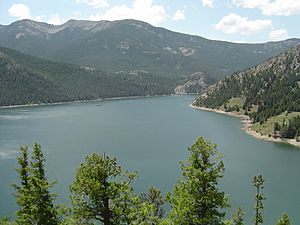
Teton County in Montana is a special place with many beautiful bodies of water. You can find at least 30 named lakes and reservoirs here! These watery spots are super important for local wildlife, fun outdoor activities, and providing water for people and farms. Let's explore some of these amazing natural and man-made water wonders.
Natural Lakes in Teton County
Lakes are natural bodies of water, usually filled with fresh water. They are often formed by things like ancient glaciers, flowing rivers, or even changes in the land over thousands of years. In Teton County, you'll find many different lakes, each with its own unique features and importance to the area.
- Basin Lake, 47°36′42″N 112°17′48″W / 47.61167°N 112.29667°W / 47.61167; -112.29667 (Basin Lake), sits at about 4,367 feet (1,331 m) above sea level.
- Davis Lake, 47°40′15″N 112°01′47″W / 47.67083°N 112.02972°W / 47.67083; -112.02972 (Davis Lake), is around 3,770 feet (1,150 m) high.
- Eyraud Lakes, 47°59′09″N 112°02′05″W / 47.98583°N 112.03472°W / 47.98583; -112.03472 (Eyraud Lakes), are located at an elevation of 3,763 feet (1,147 m).
- Freezeout Lake, 47°40′00″N 112°03′03″W / 47.66667°N 112.05083°W / 47.66667; -112.05083 (Freezeout Lake), is a well-known lake at 3,766 feet (1,148 m).
- Glendora Lake, 47°52′59″N 112°14′23″W / 47.88306°N 112.23972°W / 47.88306; -112.23972 (Glendora Lake), has an elevation of 3,999 feet (1,219 m).
- Lake Theboe, 47°47′51″N 112°34′04″W / 47.79750°N 112.56778°W / 47.79750; -112.56778 (Lake Theboe), is quite high at 4,675 feet (1,425 m).
- Middle Lake, 47°59′00″N 112°02′15″W / 47.98333°N 112.03750°W / 47.98333; -112.03750 (Middle Lake), is at 3,747 feet (1,142 m).
- Our Lake, 47°50′12″N 112°48′39″W / 47.83667°N 112.81083°W / 47.83667; -112.81083 (Our Lake), is one of the highest at 7,283 feet (2,220 m).
- Pond Number Five, 47°40′40″N 112°02′19″W / 47.67778°N 112.03861°W / 47.67778; -112.03861 (Pond Number Five), is at 3,770 feet (1,150 m).
- Pond Number Four, 47°42′00″N 112°04′16″W / 47.70000°N 112.07111°W / 47.70000; -112.07111 (Pond Number Four), is also at 3,770 feet (1,150 m).
- Pond Number One, 47°42′53″N 112°03′52″W / 47.71472°N 112.06444°W / 47.71472; -112.06444 (Pond Number One), sits at 3,773 feet (1,150 m).
- Pond Number Six, 47°39′35″N 112°01′29″W / 47.65972°N 112.02472°W / 47.65972; -112.02472 (Pond Number Six), is at 3,770 feet (1,150 m).
- Pond Number Three, 47°42′00″N 112°03′36″W / 47.70000°N 112.06000°W / 47.70000; -112.06000 (Pond Number Three), is at 3,770 feet (1,150 m).
- Pond Number Two, 47°42′11″N 112°03′04″W / 47.70306°N 112.05111°W / 47.70306; -112.05111 (Pond Number Two), is at 3,773 feet (1,150 m).
- Priest Butte Lake, 47°46′00″N 112°06′53″W / 47.76667°N 112.11472°W / 47.76667; -112.11472 (Priest Butte Lake), has an elevation of 3,766 feet (1,148 m).
- Reickoff Lakes, 47°50′33″N 112°15′37″W / 47.84250°N 112.26028°W / 47.84250; -112.26028 (Reickoff Lakes), are at 4,062 feet (1,238 m).
- Round Lake, 47°58′41″N 112°02′01″W / 47.97806°N 112.03361°W / 47.97806; -112.03361 (Round Lake), is at 3,753 feet (1,144 m).
- Split Rock Lake, 47°39′40″N 112°31′23″W / 47.66111°N 112.52306°W / 47.66111; -112.52306 (Split Rock Lake), is at 4,298 feet (1,310 m).
- Tunnel Lake, 47°38′58″N 112°35′57″W / 47.64944°N 112.59917°W / 47.64944; -112.59917 (Tunnel Lake), has an elevation of 4,327 feet (1,319 m).
- Twin Lakes, 47°53′32″N 112°36′20″W / 47.89222°N 112.60556°W / 47.89222; -112.60556 (Twin Lakes), are at 4,777 feet (1,456 m).
Man-Made Reservoirs
Unlike natural lakes, reservoirs are bodies of water created by people. They are usually made by building a large dam across a river or stream to hold back water. Reservoirs are super important because they store water for drinking, for watering crops (this is called irrigation), and sometimes even for generating electricity.
- Burd Hill Lake, 47°46′36″N 112°14′57″W / 47.77667°N 112.24917°W / 47.77667; -112.24917 (Burd Hill Lake), is a reservoir at 3,996 feet (1,218 m).
- Bynum Reservoir, 47°57′44″N 112°24′30″W / 47.96222°N 112.40833°W / 47.96222; -112.40833 (Bynum Reservoir), is at 4,167 feet (1,270 m).
- Dougcliff Reservoir, 47°48′33″N 112°22′37″W / 47.80917°N 112.37694°W / 47.80917; -112.37694 (Dougcliff Reservoir), has an elevation of 4,268 feet (1,301 m).
- Eureka Reservoir, 47°52′42″N 112°19′04″W / 47.87833°N 112.31778°W / 47.87833; -112.31778 (Eureka Reservoir), is at 4,124 feet (1,257 m).
- Farmers Reservoir, 47°55′14″N 112°21′59″W / 47.92056°N 112.36639°W / 47.92056; -112.36639 (Farmers Reservoir), is at 4,203 feet (1,281 m).
- Gibson Reservoir, 47°36′12″N 112°45′39″W / 47.60333°N 112.76083°W / 47.60333; -112.76083 (Gibson Reservoir), is one of the larger ones at 4,869 feet (1,484 m).
- Harvey Lake, 47°55′45″N 112°23′39″W / 47.92917°N 112.39417°W / 47.92917; -112.39417 (Harvey Lake), is at 4,229 feet (1,289 m).
- John Lane Reservoir, 47°46′48″N 112°36′33″W / 47.78000°N 112.60917°W / 47.78000; -112.60917 (John Lane Reservoir), is quite high at 4,947 feet (1,508 m).
- Pishkun Reservoir, 47°40′36″N 112°29′41″W / 47.67667°N 112.49472°W / 47.67667; -112.49472 (Pishkun Reservoir), is at 4,373 feet (1,333 m).
- Theboe Lake, 47°47′42″N 112°34′03″W / 47.79500°N 112.56750°W / 47.79500; -112.56750 (Theboe Lake), is at 4,678 feet (1,426 m).
See also


