Davis Lake facts for kids
Quick facts for kids Davis Lake |
|
|---|---|

Davis Lake
|
|
| Location | Deschutes National Forest, Klamath and Deschutes counties, Oregon |
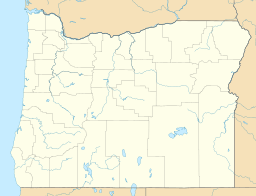
| Coordinates | 43°36′57″N 121°50′39″W / 43.61583°N 121.84417°W |
| Lake type | Natural, mesotrophic |
| Primary inflows | Odell Creek Ranger Creek |
| Primary outflows | Seepage |
| Catchment area | 118 square miles (310 km2) |
| Basin countries | United States |
| Surface area | 1,000 to 3,906 acres (405 to 1,581 ha) |
| Average depth | 9 ft (2.7 m) |
| Max. depth | 22 ft (6.7 m) |
| Water volume | 35,940 acre-feet (44,330,000 m3) |
| Residence time | 4 months |
| Surface elevation | 4,386 ft (1,337 m) |
Davis Lake is a cool lake located in Oregon, United States. It sits right on the border between Deschutes County and Klamath County. This lake is pretty big but not very deep. You can find it inside the beautiful Deschutes National Forest. It's also known as one of the best places in Oregon for bass fishing!
Contents
History of Davis Lake
How the Lake Was Formed
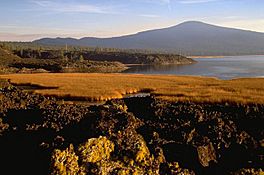
Davis Lake was created a long, long time ago by a natural event. A huge flow of lava from a nearby volcano blocked Odell Creek. This blockage caused the water to back up, forming the lake we see today.
Changing Water Levels
The size of Davis Lake changes a lot between seasons. In winter, when there's more rain and snow, the lake can cover over 3,000 acres. But in the summer, the water from Odell and Ranger creeks can't fill the lake fast enough. This is because water escapes through the lava blockage. Scientists are still not sure exactly where all that water goes!
Fishing at Davis Lake
Davis Lake is very famous for its fishing. However, there are special rules: only fly fishing with artificial flies is allowed. This means you can't use live bait. Rainbow trout are added to the lake to help their population grow naturally. These trout usually eat smaller fish, like the Tui chub, which is an unwanted fish in the lake.
The Bass Problem
In the 1980s and 1990s, there were many years of drought. This made the lake's water levels drop and the water get warmer. This was bad for the trout, which like cooler, deeper water.
Then, in 1995, something unexpected happened. Someone illegally put largemouth bass into the lake. These bass started eating the smaller trout. Now, there are more bass in the lake than trout. This has changed the balance of fish in Davis Lake.
Things to Do at Davis Lake
Davis Lake is a great spot for outdoor fun, especially if you love fishing and camping.
Fishing Rules
Remember, Davis Lake is a fly-fishing only lake. You can use motors on your boats, but there's a speed limit of 10 miles per hour. Trolling, which is dragging a fishing line behind a moving boat, is also allowed.
Boat Ramps
There are a few places where you can launch your boat:
- On the west side of Odell Creek.
- At South Davis Campground, which is further up Odell Creek.
- At Lava Flow Campground.
Camping at Davis Lake
If you want to stay overnight, there are three campgrounds around the lake. They offer about 70 campsites in total. You'll find one campground on the west side, one on the east side, and another near the lava flow.
All three campgrounds provide:
- Firepits for campfires.
- Picnic tables for meals.
- Toilets.
The campgrounds on the east and west sides also have water available.
 | Dorothy Vaughan |
 | Charles Henry Turner |
 | Hildrus Poindexter |
 | Henry Cecil McBay |


