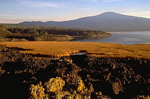
Davis Lake volcanic field facts for kids
Quick facts for kids Davis Lake volcanic field |
|
|---|---|
 |
|
| Location | Deschutes / Klamath counties, Oregon, U.S. |
| Range | Cascades |
| Highest point – elevation – coordinates |
Hamner Butte 7,103 ft (2,165 m) 43°33′33″N 121°48′46″W / 43.559258250°N 121.812858139°W |
| Geology | Cinder cone, Lava flow, and shield volcano |
| Age | Holocene |
| Volcanic arc | Cascade Volcanic Arc |
| Last eruption | 2790 BC (?) |
The Davis Lake volcanic field is a fascinating area in Oregon, United States. It's a collection of different types of volcanoes and lava. You can find cinder cones, lava flows, and shield volcanoes here.
This volcanic field is located east of the Cascade Range. The Cascade Range is a famous chain of volcanoes that stretches across western North America. The Davis Lake field is part of the larger Cascade Volcanic Arc.
What is the Davis Lake Volcanic Field?
A volcanic field is an area with many small volcanoes. These volcanoes might have erupted at different times. The Davis Lake field has volcanoes made of different types of lava. Some are called andesitic and basaltic andesite. These names describe the chemical makeup of the lava.
The volcanoes here include cinder cones. These are cone-shaped hills built from bits of hardened lava and ash. There are also shield volcanoes, which have a broad, gently sloping shape like a warrior's shield. This shape comes from very fluid lava flows.
The last known eruption in this field was around 2790 BC. This means the volcanoes are quite old, but they are still part of the Holocene epoch. The Holocene is the current geological period, which started about 11,700 years ago.
Volcanoes You Can Find Here
The Davis Lake volcanic field has several notable volcanic vents. A vent is an opening in the Earth's surface where volcanic materials come out. These vents are often called "buttes" or "mountains" in this area.
Here are some of the important vents in the Davis Lake volcanic field:
| Name | Elevation | Coordinates |
| Cryder Butte | 5,479 ft (1,670 m) | 43°33′49″N 121°43′02″W / 43.5637340°N 121.7172483°W |
| Davis Mountain | 6,624 ft (2,019 m) | 43°37′45″N 121°46′00″W / 43.6292878°N 121.7666941°W |
| Hamner Butte | 7,103 ft (2,165 m) | 43°33′33″N 121°48′46″W / 43.559258250°N 121.812858139°W |
| Little Odell Butte | 5,541 ft (1,689 m) | 43°26′37″N 121°54′17″W / 43.4437368°N 121.9047501°W |
| Odell Butte | 7,011 ft (2,137 m) | 43°28′15″N 121°51′50″W / 43.4709584°N 121.8639165°W |
| Pine Butte | 5,240 ft (1,597 m) | 43°39′41″N 121°50′43″W / 43.6615099°N 121.8453067°W |
| Ringo Butte | 6,079 ft (1,853 m) | 43°32′59″N 121°45′18″W / 43.5498453°N 121.7550265°W |
| Royce Mountain | 6,148 ft (1,874 m) | 43°31′11″N 121°54′08″W / 43.5198466°N 121.9022509°W |
 | Janet Taylor Pickett |
 | Synthia Saint James |
 | Howardena Pindell |
 | Faith Ringgold |

