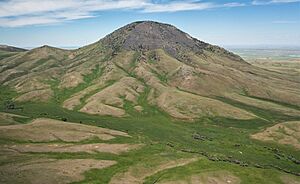
List of mountains in Liberty County, Montana facts for kids
Liberty County, Montana, is a cool place in the northern part of the state. It's known for its wide-open spaces and, you guessed it, mountains! Even though Montana has many huge mountain ranges, Liberty County has its own special peaks. These mountains are important parts of the landscape, offering amazing views and homes for wildlife.
There are at least 12 named mountains in Liberty County, Montana. These natural giants stand tall, some reaching thousands of feet into the sky. When we talk about how high a mountain is, we use something called elevation. This means how far up the mountain is from the average level of the ocean, which is called sea level.
What is a Mountain?
A mountain is a large natural rise of the Earth's surface. It's usually bigger and steeper than a hill. Mountains are formed over millions of years by powerful forces deep within the Earth. They can be created when huge pieces of the Earth's crust, called tectonic plates, crash into each other. This pushes the land upwards, forming towering peaks.
Mountains are super important for many reasons. They help shape the weather, acting like big walls that can block clouds and cause rain or snow. They are also home to many different kinds of plants and animals. Plus, mountains offer amazing places for people to explore, hike, and enjoy nature!
Notable Peaks in Liberty County
Liberty County is home to a variety of mountains, each with its own unique features and elevation. Here's a look at some of the named peaks you can find there:
- Black Jack Butte: This mountain stands at about 5,200 feet (1,585 meters) high. It's located in the northern part of the county. 48°53′57″N 111°06′21″W / 48.89917°N 111.10583°W
- Devils Chimney: Reaching an elevation of about 5,515 feet (1,681 meters), Devils Chimney is one of the taller peaks. 48°51′40″N 111°06′57″W / 48.86111°N 111.11583°W
- East Butte: Close to Devils Chimney, East Butte is about 5,499 feet (1,676 meters) tall. 48°51′39″N 111°06′56″W / 48.86083°N 111.11556°W
- Hawley Hill: This hill is around 4,468 feet (1,362 meters) high. 48°54′05″N 111°13′42″W / 48.90139°N 111.22833°W
- Haystack Butte: Standing at about 4,498 feet (1,371 meters), Haystack Butte gets its name from its shape. 48°47′18″N 111°12′28″W / 48.78833°N 111.20778°W
- Ikes Butte: This peak is about 4,147 feet (1,264 meters) in elevation. 48°58′42″N 111°10′36″W / 48.97833°N 111.17667°W
- McGuire Hill: One of the lower elevations on the list, McGuire Hill is about 4,006 feet (1,221 meters) high. 48°45′42″N 111°07′18″W / 48.76167°N 111.12167°W
- Morgan Hill: This hill reaches an elevation of about 4,190 feet (1,277 meters). 48°55′45″N 111°11′31″W / 48.92917°N 111.19194°W
- Mount Brown: This is one of the tallest mountains in Liberty County, soaring to about 6,922 feet (2,110 meters)! 48°52′26″N 111°08′21″W / 48.87389°N 111.13917°W
- Mount Lebanon: With an elevation of about 5,725 feet (1,745 meters), Mount Lebanon is another significant peak. 48°52′05″N 111°03′39″W / 48.86806°N 111.06083°W
- Mount Lily: This mountain is about 4,239 feet (1,292 meters) high. 48°56′07″N 111°05′50″W / 48.93528°N 111.09722°W
- Mount Royal: Another very tall mountain, Mount Royal stands at about 6,844 feet (2,086 meters). 48°51′15″N 111°08′28″W / 48.85417°N 111.14111°W
These mountains add to the natural beauty and rugged landscape of Liberty County. They provide habitats for local wildlife and offer stunning views for anyone who visits or lives nearby.
See also
 | William Lucy |
 | Charles Hayes |
 | Cleveland Robinson |


