Liberty County, Montana facts for kids
Quick facts for kids
Liberty County
|
|
|---|---|

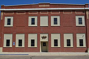
Liberty County Courthouse in Chester
|
|

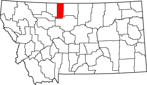
Location within the U.S. state of Montana
|
|
 Montana's location within the U.S. |
|
| Country | |
| State | |
| Founded | February 11, 1920 |
| Named for | Liberty |
| Seat | Chester |
| Largest town | Chester |
| Area | |
| • Total | 1,447 sq mi (3,750 km2) |
| • Land | 1,430 sq mi (3,700 km2) |
| • Water | 17 sq mi (40 km2) 1.2% |
| Population
(2020)
|
|
| • Total | 1,959 |
| • Estimate
(2022)
|
1,972 |
| • Density | 1.3538/sq mi (0.52272/km2) |
| Time zone | UTC−7 (Mountain) |
| • Summer (DST) | UTC−6 (MDT) |
| Congressional district | 2nd |
|
|
Liberty County is a special area in the state of Montana, USA. It's like a big neighborhood with its own local government. In 2020, about 1,959 people lived there. The main town, where the county government is, is called Chester.
People voted in 1919 to create Liberty County from parts of Hill and Chouteau counties. It officially started in February 1920. You can find the Tiber Dam in the southwest part of Liberty County. It's a fun place for visitors and outdoor activities.
Contents
Where is Liberty County?
Liberty County is located in the northern part of Montana. It shares a border with Canada, right next to the Canadian province of Alberta. The United States Census Bureau says the county covers about 1,447 square miles. Most of this area, about 1,430 square miles, is land. The rest, about 17 square miles, is water.
Nearby Counties
Liberty County has several neighbors:
- Toole County – to the west
- Pondera County – to the southwest
- Chouteau County – to the south
- Hill County – to the east
- County of Forty Mile No. 8, Alberta – to the north (in Canada)
People Living in Liberty County
The number of people living in Liberty County has changed over the years. Here's a look at the population from different census counts:
| Historical population | |||
|---|---|---|---|
| Census | Pop. | %± | |
| 1920 | 2,416 | — | |
| 1930 | 2,198 | −9.0% | |
| 1940 | 2,209 | 0.5% | |
| 1950 | 2,180 | −1.3% | |
| 1960 | 2,624 | 20.4% | |
| 1970 | 2,359 | −10.1% | |
| 1980 | 2,329 | −1.3% | |
| 1990 | 2,295 | −1.5% | |
| 2000 | 2,158 | −6.0% | |
| 2010 | 2,339 | 8.4% | |
| 2020 | 1,959 | −16.2% | |
| 2022 (est.) | 1,972 | −15.7% | |
| U.S. Decennial Census 1790–1960 1900–1990 1990–2000 2010–2020 |
|||
What the 2020 Census Shows
In 2020, the official count showed that 1,959 people lived in Liberty County.
What the 2010 Census Showed
Back in 2010, there were 2,339 people living in the county. They lived in 822 homes, and 537 of these were families. On average, there were about 1.6 people per square mile.
Most people in the county were white (98.2%). A small number were American Indian, Black, or Asian. About 1.2% of people were from two or more racial backgrounds. A very small percentage (0.3%) were of Hispanic or Latino origin.
Many people in Liberty County have family roots from Europe. For example, 55.4% had German ancestors, 24.1% had Norwegian ancestors, and 14.5% had Irish ancestors.
The average age of people in Liberty County in 2010 was 44.6 years old. About 23.7% of homes had children under 18 living there. Most homes (59.5%) were married couples living together.
The average income for a household was about $40,212 per year. For families, it was around $44,957. About 19.5% of all people in the county lived below the poverty line. This included 31.6% of those under 18 years old.
Towns and Communities
Liberty County has one main town and several smaller communities.
Main Town
- Chester (This is the county seat, meaning it's where the county government is located.)
Other Communities
These are places where people live, but they might not be official towns.
Small Unincorporated Places
These are even smaller communities that are not officially part of a town or city.
- Hill
- Lothair
- Tiber
See also
 In Spanish: Condado de Liberty (Montana) para niños
 | James Van Der Zee |
 | Alma Thomas |
 | Ellis Wilson |
 | Margaret Taylor-Burroughs |

