
List of places on the Victorian Heritage Register in the City of Whittlesea facts for kids
The City of Whittlesea in Victoria, Australia, is home to many important historical sites. These places are listed on the Victorian Heritage Register, which is like a special list of buildings, areas, and objects that are very important to Victoria's history. The Heritage Council of Victoria looks after this register to make sure these places are protected for future generations to enjoy and learn from.
As of 2020, there are 14 places in the City of Whittlesea that are officially recognized on the Victorian Heritage Register. These sites tell us stories about how people lived, worked, and built communities in the past.
Contents
- Protecting Victoria's Past: Heritage Sites in Whittlesea
- Famous Historic Places You Can Find in Whittlesea
- Bear's Castle: A Glimpse into Early Settlement
- Thomastown Lutheran Church and Cemetery: A Community's History
- Yan Yean Water Supply System: Bringing Water to Melbourne
- Historic Schools: Learning About Education's Past
- Farms and Homesteads: Life on the Land
- Horse-Drawn Stone-Carrying Sled: A Unique Tool
- Why These Places Matter to Us Today
- Famous Historic Places You Can Find in Whittlesea
- Images for kids
Protecting Victoria's Past: Heritage Sites in Whittlesea
The Victorian Heritage Register helps us understand and protect places that have special historical, architectural, or cultural value. When a place is added to this list, it means it's considered very important. This helps make sure these sites are looked after and kept safe.
Famous Historic Places You Can Find in Whittlesea
Let's explore some of the interesting places on the register within the City of Whittlesea. Each one has a unique story to tell about the area's development.
Bear's Castle: A Glimpse into Early Settlement
One of the oldest places on the list is Bear's Castle, built around 1846 in Yan Yean. Despite its name, it's not a real castle with knights and dragons! It's an early building that shows us how people lived when the area was first settled. It's a reminder of the pioneers who came to Victoria long ago.

Thomastown Lutheran Church and Cemetery: A Community's History
The Thomastown Lutheran Church and Cemetery in Lalor was built in 1856. This site is important because it shows the history of the early German settlers in the area. The church and its cemetery tell us about their community life, beliefs, and how they established themselves in Victoria. It's a place where you can feel the history of a whole group of people.

Yan Yean Water Supply System: Bringing Water to Melbourne
The Yan Yean Water Supply System is a huge and very important heritage site. Built between 1853 and 1857, it was one of the first major water supply systems for Melbourne. It runs through several suburbs, including Whittlesea, Yan Yean, and Bundoora. This system was crucial for the growth of Melbourne, providing clean water to its residents. It shows amazing engineering for its time.

Historic Schools: Learning About Education's Past
Several old schools in Whittlesea are also on the register. The Old Bundoora Primary School (1877), Old South Morang Primary School (1877), and Whittlesea Primary School (1878) are all recognized. These buildings show us what school life was like more than a hundred years ago. They are important reminders of how education developed in the region.

Farms and Homesteads: Life on the Land
Many heritage sites in Whittlesea are old farms and homesteads. These include Fashoda Homestead (circa 1855) in Mernda, Graff's Farm (1873) and Siebel's Farmhouse (1860) in Thomastown, and Summerhill (1850s) in Wollert. Wuchatsch's Farm (1850s) and Ziebell's Farm (1850s) in Lalor are also on the list. These places highlight the agricultural history of the area and how early settlers worked the land.
Horse-Drawn Stone-Carrying Sled: A Unique Tool
An interesting item on the register is the Horse-Drawn Stone-Carrying Sled from around 1858, located in Epping. This unique piece of equipment tells us about the tools and methods used for construction and farming in the past, before modern machinery existed.
Why These Places Matter to Us Today
These heritage sites are more than just old buildings or objects. They are important links to our past. By protecting them, we can learn about the lives of people who came before us, understand how our communities grew, and appreciate the hard work and ingenuity of past generations. They help us connect with our history and give us a sense of place.
Images for kids
-
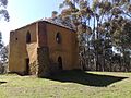
Bear's Castle, a historic building in Yan Yean.
-
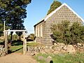
The historic Thomastown Lutheran Church.
-
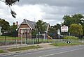
Whittlesea Primary School, built in 1878.
-
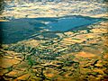
Part of the Yan Yean Water Supply System.
