kids encyclopedia robot

List of places on the Victorian Heritage Register in the Rural City of Mildura facts for kids

Kids Encyclopedia Facts

This is a list of places on the Victorian Heritage Register in the Rural City of Mildura in Victoria, Australia. The Victorian Heritage Register is maintained by the Heritage Council of Victoria.

The Victorian Heritage Register, as of 2020, lists the following 14 state-registered places within the Rural City of Mildura:

Place name Place # Location Suburb or Town Co-ordinates Built State
registered
Photo
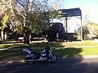
Big Lizzie H1919 cnr Calder Hwy and Jamieson Ave Red Cliffs 34°18′29″S 142°11′13″E / 34.307960°S 142.186820°E / -34.307960; 142.186820 1915 15 March 2001 Big Lizzie.JPG
Billabong Pumping Station H0547 Cooke St Nichols Point 34°13′48″S 142°13′12″E / 34.229890°S 142.219870°E / -34.229890; 142.219870 1889 26 October 1983
Horticulture Research Station H2316 571-585 River Ave Merbein South 34°12′45″S 142°02′30″E / 34.212610°S 142.041680°E / -34.212610; 142.041680 1919 13 December 2012
Irymple railway station H1568 Railway Crescent Irymple 34°14′26″S 142°10′20″E / 34.240600°S 142.172250°E / -34.240600; 142.172250 1903 20 August 1982
Kow Plains Homestead H0688 99 Cowangie South Rd Cowangie 35°14′24″S 141°23′30″E / 35.239970°S 141.391700°E / -35.239970; 141.391700 1879 15 June 1988
Lock Nine Pumping Station H0549 Lock 9 Rd Cullulleraine 34°11′29″S 141°36′13″E / 34.191290°S 141.603630°E / -34.191290; 141.603630 1926 26 October 1983
Methodist Church H0588 126-132A Deakin Ave Mildura 34°11′19″S 142°09′33″E / 34.188660°S 142.159170°E / -34.188660; 142.159170 1912 3 October 1984 MilduraMethodistChurch.JPG
Mildara Blass Distillery H1099 2 Wentworth Rd Merbein 34°10′01″S 142°04′48″E / 34.167030°S 142.079920°E / -34.167030; 142.079920 1913 14 September 1995
Murrayville Consolidated School H1185 27 Poole St Murrayville 35°15′53″S 141°10′49″E / 35.264740°S 141.180370°E / -35.264740; 141.180370 1943 19 December 1996
Murrayville railway station H1580 McKenzie St Murrayville 35°15′41″S 141°11′00″E / 35.261460°S 141.183220°E / -35.261460; 141.183220 1912 20 August 1982
Old Mildura Base Hospital H1934 137-157 Thirteenth St Mildura 34°11′27″S 142°09′05″E / 34.190970°S 142.151250°E / -34.190970; 142.151250 1934 10 May 2001
Old Nichols Point Primary School Shelter Shed H2363 110 Koorlong Ave Nichols Point 34°12′36″S 142°12′11″E / 34.209960°S 142.203040°E / -34.209960; 142.203040 1911 14 July 2016
Psyche Bend Pumping Station H0548 Psyche Bend Rd Irymple 34°15′13″S 142°13′51″E / 34.253480°S 142.230760°E / -34.253480; 142.230760 1891 26 October 1983 MilduraPsycheBendPumpHouse.JPG
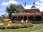
Rio Vista H0729 199-205 Cureton Ave Mildura 34°10′38″S 142°09′31″E / 34.177340°S 142.158630°E / -34.177340; 142.158630 1889 3 May 1989 Rio Vista, Mildura VIC.jpg
kids search engine
List of places on the Victorian Heritage Register in the Rural City of Mildura Facts for Kids. Kiddle Encyclopedia.