Loch Bad an Sgalaig facts for kids
Quick facts for kids Loch Bad an Sgalaig |
|
|---|---|

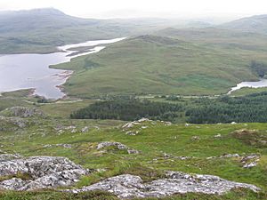
From Meall Aundrary to Loch Bad an Sgalaig
|
|
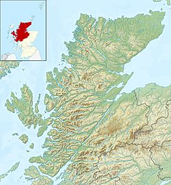
| Location | Wester Ross, Scotland |
| Coordinates | 57°40′32″N 5°36′33″W / 57.67556°N 5.60917°W |
| Type | freshwater loch and reservoir |
| Primary inflows | Abhainn a' Gharbh Choire |
| Basin countries | Scotland |
| Max. length | 0.66 mi (1.06 km) |
| Max. width | 0.5 mi (0.80 km) |
| Surface area | 132.2 ha (327 acres) |
| Average depth | 24.25 ft (7.39 m) |
| Max. depth | 64 ft (20 m) |
| Water volume | 151,000,000 cu ft (4,300,000 m3) |
| Shore length1 | 10.2 km (6.3 mi) |
| Surface elevation | 116 m (381 ft) |
| 1 Shore length is not a well-defined measure. | |
Loch Bad an Sgalaig is a small, irregular shaped, freshwater loch and reservoir lying 5 mi (8.0 km) south of the small village of Poolewe, in Wester Ross, Scotland.
The north west end of the loch, where it outflows to the Eas na Laimh stream, was dammed in 1949 to power the Kerry Falls hydroelectric power station.
The loch was surveyed on 30 July 1902 by T.N. Johnston and John Hewitt and later charted as part of the Sir John Murray's Bathymetrical Survey of Fresh-Water Lochs of Scotland 1897-1909.

All content from Kiddle encyclopedia articles (including the article images and facts) can be freely used under Attribution-ShareAlike license, unless stated otherwise. Cite this article:
Loch Bad an Sgalaig Facts for Kids. Kiddle Encyclopedia.

