Loch Benachally facts for kids
Quick facts for kids Loch Benachally |
|
|---|---|

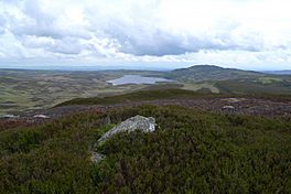
The summit of Spurn Hill looking south by south-east to Loch Benachally in the distance.
|
|
| Coordinates | 56°38′06″N 3°30′58″W / 56.635°N 3.516°W |
| Type | freshwater reservoir |
| Primary outflows | Benachally Burn |
| Max. length | 1.641 km (1.020 mi) |
| Max. width | 0.74 km (0.46 mi) |
| Surface area | 173 ha (430 acres) |
| Average depth | 24.93 ft (7.60 m) |
| Max. depth | 63.97 ft (19.50 m) |
| Water volume | 179,777,998 cu ft (5,090,746.0 m3) |
| Shore length1 | 4 km (2.5 mi) |
| Surface elevation | 308 m (1,010 ft) |
| Max. temperature | 57.2 °F (14.0 °C) |
| Min. temperature | 48.8 °F (9.3 °C) |
| Islands | 0 |
| 1 Shore length is not a well-defined measure. | |
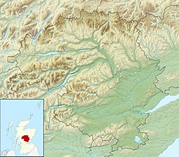
Loch Benachally is a big, shallow lake in Scotland. It's actually a special type of lake called a freshwater reservoir. This means it's a place where water is stored, often to supply homes and businesses. You can find it near the beautiful Forest of Clunie in an area called Perth and Kinross. Scottish Water manages this reservoir, making sure it provides clean water for everyone.
Ancient Homes at Loch Benachally
Around Loch Benachally, you can find exciting clues about people who lived here long, long ago. These clues are the remains of villages from the Iron Age. The Iron Age was a time in history when people started using iron tools and weapons.
Iron Age Villages South-East of the Loch
If you look south-east of the reservoir, you can see what's left of an Iron Age village. From above, it looks like a street! This village had six hut circles, which were the round foundations of their homes. These huts were connected in a line, almost like houses on a street. There was also one hut a bit further away.
The huts varied in size, from about 13 meters (about 43 feet) to 8.3 meters (about 27 feet) across. Some of them had stone walls around them. The people who lived here also had a field system. This means they had special areas for growing crops. You can still see the marks of their fields, including old walls and piles of stones they cleared from the land.
Iron Age Villages East of the Loch
To the east and north-east of Loch Benachally, near the dam, there's another Iron Age village site. This one is even bigger, with 12 hut circles! These huts are also arranged in a line, running from north-west to south-east.
The huts here were a bit smaller, ranging from 11.3 meters (about 37 feet) down to 3.7 meters (about 12 feet) across. This settlement also had a clear field system, with a large field to the north and west, and a smaller one to the south. It's amazing to think that people lived and farmed here thousands of years ago!
 | Laphonza Butler |
 | Daisy Bates |
 | Elizabeth Piper Ensley |


