
Loch Dùghaill facts for kids
Quick facts for kids Loch DùghaillLoch Doule Loch Doughaill |
|
|---|---|
 |
|

Loch Dùghaill
Loch Doule Loch Doughaill Location in Highland
|
|
| Location | Wester Ross, Scotland |
| Coordinates | 57°28′19″N 5°20′26″W / 57.47194°N 5.34056°W |
| Type | freshwater loch |
| Primary inflows | River Carron |
| Primary outflows | River Carron |
| Basin countries | United Kingdom |
| Max. length | 2 kilometres (1.2 mi) |
| Max. width | 0.6 metres (2 ft 0 in) |
| Average depth | 174 feet (53 m) |
| Surface elevation | 93 feet 1 inch (28.37 m) |
| Settlements | Achnashellach |
Loch Dùghaill (pronounced 'Doo-gal') is a beautiful freshwater loch, which is a type of lake found in Scotland. It's located in an area called Wester Ross. This loch is part of the River Carron system.
You can find the A890 road and the Kyle of Lochalsh Line railway running along its northwest side. Another larger body of water, Loch Carron, is about 8 kilometers (5 miles) down the river from Loch Dùghaill.
Exploring Loch Dùghaill's Landscape
Loch Dùghaill stretches from the southwest to the northeast. The land around the loch is quite varied and interesting.
East and West Shores
The eastern side of the loch has very steep cliffs. These cliffs rise almost straight up to a high, flat area called the plateau of Creag An Eilein. This dramatic landscape continues past the end of the loch, getting even higher before it levels out near Strathcarron.
Further up on the east side, you'll find the mountain of Sgurr na Feartaig, which stands at 862 meters (2,828 feet) tall. The western side of the loch is different. It has a gentler slope at first, where the railway and road are. However, this slope quickly becomes steeper as it rises towards Fuar Tholl, a mountain reaching 907 meters (2,976 feet).
Southern End Features
At the southern end of Loch Dùghaill, the loch opens up. This is where the water flows out into the River Carron. There are also several smaller, flat pools of water, called lochans, on the flat land at this end of the loch.
Gallery
- Images of Loch Dùghaill and surrounding areas
-
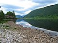
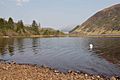
Loch Dùghaill Looking towards Achnashellach. The steep rise leading to the plateau of Creag An Eilein is visible to the right.
-
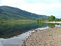
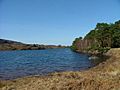
Loch Dùghaill Looking southwest from near Balnacra.
-
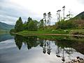
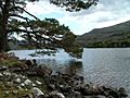
Shoreline of Loch Dùghaill Looking across a small bay on the north shore of the loch.
-
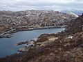
Looking down on Loch Dùghaill
-
Loch Dughaill. The eastern end of the loch
-
Loch Dughaill. Looking southeast from the boathouse.
-

Looking over Loch Dùghaill From the shore near Balnacra.
-

Small bay on Loch Dùghaill
-
Loch Dughaill In Glen Shieldaig.


